Method
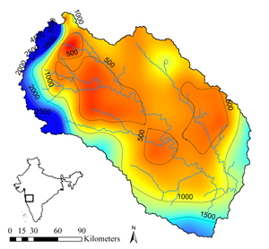
The Upper Bhima catchment (45,678 km2) is located on Bhima river which is one of the main tributaries of Krishna river in the upstream part of the basin. It originates in the Western Ghat mountains and covers part of the Maharasthra state. The catchment is located between 16.5o -19.5o latitude and 73.0o -76.5o longitude. The elevation ranges from 414 meter in the east to 1458 meter in the Western Ghat mountains and 95% of the catchment is below 800 meter and relatively flat.
The Upper Bhima catchment comprises of the catchment area of the river Bhima from its source to its confluence with the Sina River. The Sina River drains the north eastern part of the catchment. The catchment is an important source of water for the entire Krishna basin since a major part of the precipitation falls in the Western Ghat range in the east of the catchment and is retained and released to downstream areas through an intricate set of reservoirs, especially along the Bhima tributary. The reservoirs accumulate water during the monsoon season (June to October), and this is gradually released throughout the irrigation season (October to May). Flows in the rivers are therefore mainly human controlled and respond less directly to variations in the climate excitations and biophysical conditions and are therefore less suitable to use for calibration.
A SWAT model was built and simulations were run on a daily basis from June 2004 to May 2005. SWAT is a distributed hydrological model providing spatial coverage of the integral hydrological cycle including atmosphere, plants, unsaturated zone, groundwater and surface water. The model is comprehensively described in literature (Arnold et al., 1998; Srinivasan et al., 1998).
The Surface Energy Balance Algorithm for Land (SEBAL)was applied to spatially estimate total actual evapotranspiration (ETact) between October 2004 and September 2005 based on MODIS satellite imagery. SEBAL uses satellite imagery from sensors measuring the visible, near-infrared and thermal radiation. The latent heat flux (LE) is computed on a pixel-by-pixel basis as a residual of the energy balance:
LE = Rn - G - H
The SEBAL results were used to calibrate the SWAT model in time and space using the Parameter ESTimation (PEST) software; a model independent non-linear parameter optimisation package
Arnold JG, Srinivasan P, Muttiah RS, Williams JR. 1998. Large area hydrologic modeling and assessment. Part I. Model development. Journal of the American Water Resources Association 34: 73-89.
Srinivasan R, Ramanarayanan TS, Arnold JG, Bednarz ST. 1998. Large area hydrologic modeling and assessment part II: model application. Journal of American Water Resource Association 34: 91-101.
|
|
|
||||||
|
|
 |
 |
 |
|
|
||
|
|
 |
|
|
||||
|
|
|
|
|||||
|
|
|
||||||