In the highlands of Karuzi Province, Burundi, smallholder farmers are increasingly exposed to prolonged dry spells, erratic rainfall, and fragile water-sharing arrangements between neighbouring cooperatives. Scarce and contested water resources not only undermine agricultural productivity, but also place a disproportionate burden on women and girls and have repeatedly given rise to disputes over access to springs and irrigation supplies. The Digital Peace Water (DPW) project addresses this dual challenge of climate stress and social tension by combining climate-resilient water infrastructure with transparent, data-driven governance.
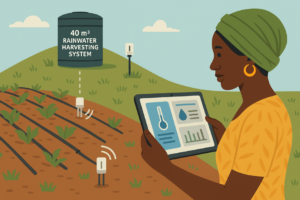
DPW is a Climate Technology Centre and Network (CTCN) Technical Assistance under the UNEP-managed AFCIA programme. The project is implemented by a consortium led by Zephyr Consulting, together with FutureWater, sensors.AFRICA (Code for Africa) and the Burundian NGO APRN/BEPB. It deploys solar-powered groundwater pumping, centralized storage and a network of IoT sensors, linked to a community-accessible dashboard that supports adaptive water allocation. By making water availability and use visible to all parties, the system is designed to reduce competition over shared resources, build trust between cooperatives, and serve as a replicable model for climate-resilient, conflict-sensitive water management in the region.
FutureWater contributes the hydrological and agronomic backbone of the system. Building on its experience with Croptimal, the satellite-based irrigation advisory service deployed in Rwanda, Zambia, Ghana and Egypt, FutureWater develops the allocation logic that translates groundwater levels, storage status, rainfall forecasts and crop water demand into operational decisions on the DPW dashboard. This includes defining the threshold-based regimes that govern abstraction under normal and dry-season conditions, peer-reviewing the hydraulic design of the borehole-and-tank systems, and analysing climate and hydrological data to inform sustainable pumping rates and storage sizing. FutureWater also supports the climate risk assessment for the pilot sites and the design of the dry-season scenarios that will be evaluated during implementation.
A second strand of FutureWater’s contribution is capacity building. In close cooperation with APRN/BEPB and the local Water Management Committees, FutureWater delivers training on data interpretation, water planning and the use of the DPW dashboard, ensuring that cooperative members, women- and youth-led groups, and local authorities can independently operate the system beyond the project duration. The pilot phase will be implemented at three sites in Karuzi, representing different hydrogeological and landscape conditions, with the explicit ambition of providing a blueprint for scale-up across Burundi and comparable contexts.

