The MRC’s State of the Basin Report (SOBR) is a flagship product of the organization and an integral part of the MRC’s strategic planning cycle. Compiled about every five years based on the available data and information, the report assesses conditions and trends within the basin and the impacts that development and use of water and related natural resources are having. The SOBR provides a statement of past trends and current conditions, and seeks to highlight and provide guidance to Member Countries on significant transboundary issues that require cooperation among basin countries to address. The SOBR 2023 is structured around the Mekong River Basin Indicator Framework, consisting of 5 dimensions: Environment, Social, Economic, Climate Change, and Cooperation.
As a longstanding collaborator of MRCS, FutureWater was engaged to support the development of the Economic and Climate Change chapters of the SOBR 2023 and perform the related activities of data analyses, advisory on data gaps and SOBR content, attractive presentation of key results, and communication with Member Countries and specialized MRCS staff to address their comments and suggestions.
The Mekong State Of the Basin Report (SOBR) is published by the Mekong River Commission (MRC) every five years, in advance of the cyclic updating of the Basin Development Strategy. The SOBR plays a key role in improving monitoring and communication of conditions in the Mekong Basin, and is MRC’s flagship knowledge and impact monitoring product. It provides information on the status and trends of water and related resources in the Mekong Basin. The 2023 SOBR is based on the MRC Indicator Framework of strategic and assessment indicators and supporting monitoring parameters, which facilitates tracking and analysis of economic, social, environmental, climate change and cooperation trends in the basin.
FutureWater was hired by MRC to perform the following tasks in support of the 2023 SOBR development:
Data collection on the Extent of Salinity intrusion in the Mekong Delta and the conditions of the Mekong River’s riverine, estuarine, and coastal habitats
Analyses of the extents of 2010, 2015, and 2020 LMB wetlands
Analyses of the extents of key fisheries habitat areas in the LMB, and
Data collection for all Assessment Indicators of MRB-IF for the Upper Mekong River Basin (UMB), including reporting and extracting key messages
Implementation of tasks 1 – 3 is achieved by using state-of-the-art remote sensing tools, such as the Google Earth Engine, building on the methods developed in the preceding project.
Task 4 builds on the findings of FutureWater’s contribution to the 2018 SOBR regarding the status of the UMB in China and Myanmar, more details can be found here.
The objectives of this climate risk assessment for the Li River in China is to assess current flood risk and future flood risk in the Li river basin in China. With an average of 1800 mm annual total rainfall, floods are severe and frequent in the region. Additionally to rainfall, severe floods in are often related to discharges from upstream reservoirs
Given the fact that this area is data scarce, global datasets with climatic data (ERA5-Land), soil parameters (HiHydroSoil) and land cover (Copernicus) were used to feed a hydrological HEC-HMS model to calculate the discharge for the extreme event of June 2020. Based on measured water levels and discharge, it was possible to develop rating curves and with these rating curves, it was possible to estimate water levels in the river for current (validation) and future conditions. This analysis served as input for the full climate risk assessment, in which possible interventions were proposed to reduce flood risk in the future.
The SREB is part of the Belt and Road Initiative, being a development strategy that focuses on connectivity and cooperation between Eurasian countries. Essentially, the SREB includes countries situated on the original Silk Road through Central Asia, West Asia, the Middle East, and Europe. The initiative calls for the integration of the region into a cohesive economic area through building infrastructure, increasing cultural exchanges, and broadening trade. A major part of the SREB traverses Asia’s high-altitude areas, also referred to as the Third Pole or the Asian Water Tower. In the light of the planned development for the SREB traversing the Third Pole and its immediate surroundings, the “Pan-Third Pole Environment study for a Green Silk Road (Pan-TPE)” program will be implemented.
The project will assess the state and fate of water resources in the region under following research themes:
1. Observed and projected Pan-TPE climate change
2. Impacts on the present and future Water Tower of Asia
3. The Green Silk Road and changes in water demand
4. Adaptation for green development
Jilin Yanji Low-Carbon Climate-Resilient Urban Development in China is included in the Asian Development Bank’s (ADB) Country Operations Business Plan (2017–2019). The project is expected to have four outputs that are linked and integrated, and expected to generate co-benefits and higher efficiencies, the outputs as described in ADB’s project concept paper are as follows:
Output 1: Sustainable, low-carbon, and intelligent urban transport system implemented.
Output 2: Sponge city and climate-resilience plan completed, and infrastructure constructed.
Output 3: Water supply and wastewater management systems improved.
Output 4: Capacity inflow-carbon and climate-resilient urban infrastructure planning developed.
Yanji City is located in the Yanbian Korean Autonomous Prefecture (YKAP) in the east of Jilin Province in the economically challenged north east of the People’s Republic of China (PRC), bordering the Democratic People’s Republic of Korea (DPRK) to the southeast and the Russian Federation to the northeast. Yanji is an ancient city on the Bur-Hatong River, surrounded by hills, and its easternmost border is about 15 kilometers from the Sea of Japan.
In the context of the project a Climate Risk Assessment (CRA) will be undertaken. The CRA will follow the so-called bottom-up approach where the driving force of risks are not climate projections (GCMs), but the overall risk taking into consideration uncertainties in climate projections. This bottom-up approach is developed by increasing recognition of the fundamental uncertainty of future climate discourages the overinterpretation of model generated climate projections. In other words the main difference between the top-down and the bottom-up approach are in the use of GCM projections. The top-down approach is constraint (limited) to the GCM projections, while the bottom-up approach considers a range of potential changes in climate.
The CRA will be undertaken in four steps:
Analysis of historic climate events
Projections of future climates
Impact and vulnerability of climate change
Adaptation options and recommendations for design
Analysis will be based on a mixture of data and tools such as NASA-NEX-GDDP, WEAP, local data sources, Google Earth Engine, amongst others.
The Mekong State Of the Basin Report (SOBR) is published by the Mekong River Commission (MRC) every five years, in advance of the cyclic updating of the Basin Development Strategy. The SOBR plays a key role in improving monitoring and communication of conditions in the Mekong Basin, and is MRC’s flagship knowledge and impact monitoring product. It provides information on the status and trends of water and related resources in the Mekong Basin.
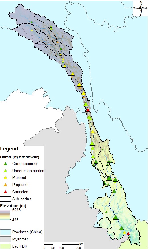
The Upper Mekong Basin in China and Myanmar
The 2018 SOBR is based on the MRC Indicator Framework of strategic and assessment indicators and supporting monitoring parameters, which facilitates tracking and analysis of economic, social, environmental, climate change and cooperation trends in the basin. Compared to earlier editions, the geographical scope of the 2018 Mekong SOBR is extended to include the Upper Mekong (“Lancang” in China) Basin. FutureWater was contracted to draft the dedicated chapters on the Myanmar and China parts of the basin.
The Upper Mekong Basin has seen rapid economic development, radical land use changes and extensive hydropower development on the mainstream. From its satellite office in Vientiane, FutureWater is currently evaluating the hydrological, environmental, economic and social status and trends of the Upper Mekong Basin. This involves elaborate consultation of a variety of information sources, including remote sensing data, public domain GIS datasets, meetings with regional experts, and review of scientific literature and technical reports. A first draft of both chapters will be completed by the end of June 2018, which will be sent to MRC member countries and dialogue partners for review. The final version of the Mekong SOBR is foreseen to be the published at the end of the year.
Cover picture: Miaowei Dam on the Upper Mekong in China (credit: CGIAR WLE Greater Mekong).
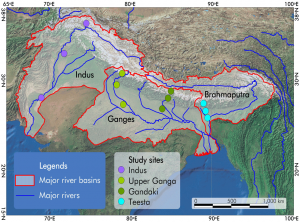
HI-AWARE is one of four consortia of the Collaborative Adaptation Research Initiative in Africa and Asia (CARIAA). HI-AWARE aims to contribute to enhanced adaptive capacities and climate resilience of the poor and vulnerable women, men, and children living in the mountains and flood plains of the Indus, Ganges, and Brahmaputra river basins through the development of robust evidence to inform people-centred and gender-inclusive climate change adaptation policies and practices for improving livelihoods.
HI-AWARE will:
Generate scientific knowledge on the biophysical, socio-economic, gender, and governance conditions and drivers leading to vulnerability to climate change;
Develop robust evidence to improve understanding of the potential of adaptation approaches and practices, with an explicit focus on gender and livelihoods;
Develop stakeholder-driven adaptation pathways based on the up- and out-scaling of institutional and on-the-ground adaptation innovations;
Promote the uptake of knowledge and adaptation practices at various scales by decision-makers and citizens; and
Strengthening the interdisciplinary expertise of researchers, students, and related science-policy-stakeholder networks.
HI-AWARE will focus its activities in 12 sites, representing a range of climates, altitudes, hydro-meteorological conditions, rural-urban continuum, and socio-economic contexts in four study basins: the Indus, Upper Ganga, Gandaki and Teesta. It will conduct research in these sites, including modeling, scoping studies, action research, and randomized control trials. It will test promising adaptation measures in observatory labs at the sites for out-scaling and up-scaling. It will also conduct participatory monitoring and assessment of climate change impacts and adaptation practices to identify:
Critical moments – times of the year when specific climate risks are highest and when specific adaptation interventions are most effective;
Adaptation turning points – adaptation turning points – when current policies and management practices are no longer effective and alternative strategies have to be considered; and
Adaptation pathways – sequences of policy actions that respond to adaptation turning points by addressing both short term responses to climate change and longer term planning.
FutureWater’s main tasks focus on biophysical drivers and conditions leading to vulnerability to climate change. Key tasks are to:
Develop detailed mountain specific and basin scale climate change scenarios;
Improve cryosphere-hydrological modeling to assess significant shifts in flow regimes with an aim to develop water demand and supply scenarios as well as improve and apply water-food impact models; and
Better understand climate change impacts on extremes (heat, floods, drought),and quantify these extremes from climate models and subsequently impact models.
Warming of the climate system is unequivocal. The atmosphere and ocean have warmed, the amounts of snow and ice have diminished, sea level has risen, and the concentrations of greenhouse gases have increased. The Himalayan region (after Antarctica and the Arctic) has the third largest amount of ice and snow in the world, and is exceptionally vulnerable. The various Global Climate Models (GCM) predict very similar future temperature trends for the region, but projections of future precipitation patterns differ widely. As a consequence, the need for increased knowledge about future climate change remains high. The main focus of GCMs thus far was on temperature increases and potential changes to the hydrological cycle. The overall tendency that has emerged is that wetter regions are likely to become wetter and drier regions drier. Increased scientific knowledge, coupled with recent weather events, show that changes in hydrological extreme events can be substantial and the geographical and temporal resolution of predicted changes remains low in many areas.
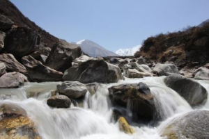
For Statkraft, as the largest generator of renewable energy in Europe and a leading company in hydropower internationally, an understanding of future changes to the hydrological cycle and its uncertainty is crucial for effective business planning. Investment decisions regarding the business strategy for the next 50 years depend on accurate predictions of climate change impacts on inflow over that period. In addition, changing probabilities and magnitudes of extreme events can put additional risk on infrastructure (dams and hydropower plants) or on other crucial infrastructure (roads and transmission lines). Statkraft’s intention to grow in the region makes it necessary to assess short, medium and long-term impacts, risks and opportunities resulting from climate change, to ensure sustainable management of the water resources for all stakeholders. Currently, Statkraft’s main business focus lies with northern India (mainly the state of Himachal Pradesh) and Nepal, while Bhutan and Myanmar might be areas of future business development as well.
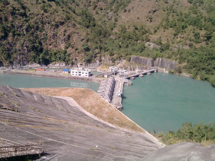
Kaligandaki Hydro power located in Nepal.
Through the International Centre for Integrated Mountain Development (ICIMOD), the inter-governmental learning and knowledge sharing Centre serving the eight regional member countries of the Hindu Kush Himalayas (HKH), FutureWater provided a comprehensive review study on climate change and the impacts on cryosphere, hydrological regimes and glacier lakes in the Indus, Ganges, and Brahmaputra river basins. This review study was done in the context of future hydropower development in the region.
The Government of Vietnam is challenged to make adequate decisions to adapt to climate change and sea level rise through an integrated approach (agriculture, industry, environment, urbanization and infrastructure). In Vietnam many meteorological stations collect the actual weather conditions. Due to changing weather conditions these historical data are not very reliable for future projection in design of water infrastructure, dikes, etc. There is a need for advanced models in the water sector where space borne imagery and state of the art water models support on predicting future behaviour of the water resources. This is important to support the government of Vietnam in their decision making on how to manage their water resources, design adequate structures (water storage, dams, infrastructure) and safety (dikes, barriers, etc). Planning is even more complex due to the fact that the water resources in Vietnam highly depend on how neighbouring countries manage their water resources. Regional monitoring systems supported by remote sensing can provide important information to the Government on water quality, water quantity, sediment load, water distribution and monitor impacts of the hydropower dams upstream/cross-border. It needs no explanation that these data support Vietnam in regional dialogue on the international rivers and support in its own improved water management.
In November 2011 during a first workshop on ‘Water and Climate Services for transboundary water management and disaster risk management’ it was decided to design a Government to Government (G2G) programme outline with emphasis on capacity development, innovative (hydrologic) models, financial engineering, business development and partnership building regarding RS and GIS technology. Against this backdrop, FutureWater was asked to perform the following activities:
Capacity building and training of experts of NRSD in Vietnam in remote sensing for rainfall and drought monitoring;
Identify suitable technologies in remote sensing, rainfall, and drought models for the monitoring and management of transboundary water and disaster risks;
Demonstrate the use of open software for rainfall and drought monitoring;
Demonstrate the use of free remote sensing data for Red River Basin transboundary water management.
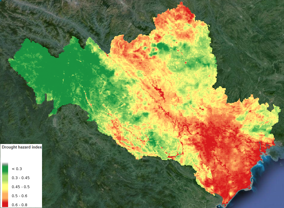
Drought Hazard Index map of the Red River Basin, as computed by the FutureWater DMIAT.
Based on different remote sensing data sources, open geodata and ground-based observations, FutureWater demonstrates the applicability of the in-house developed Drought Monitoring and Impact Assessment Toolbox (DMIAT) and HiP2P rainfall downscaling methodology for the Red River Basin in Vietnam. The Red River Delta is most suitable for piloting a multi-purpose approach in order to cover the aspects of water management and disaster risk management, including transboundary aspects.
During this pilot project, FutureWater and other Dutch partners take the first steps in developing an integrated product for transboundary water management in the Red River Basin. It is envisaged that this will lead to operational implementation and organizational embedding at the relevant Vietnamese government agencies in the coming years.
In June 2012, ISRIC, FutureWater, and Nelen en Schuurmans won the project, financed by Partners for Water. Green Water Management & Credits is a concept developed by ISRIC. It allows quantification of water supply and demand, erosion reduction, yield increase, sedimentation amounts, and hydropower production that is needed to calculate the economic costs and benefits of environmental protection measures. This information allows the development of a financial mechanism for e.g. river basins, based on upstream supply and downstream demand of water services for long term investments in local to regional communities. In order run this concept in areas, an analytical toolkit in combination with adequate database resources and knowhow is necessary. The project aims at future business cases for the partners involved, using the GWM&C concept and toolkit.
ISRIC, FutureWater, and Nelen en Schuurmans have cutting edge knowhow, experience and ownership of the necessary database resources and calculation tools. Based on this, we will develop a GWM&C toolkit. For successful implementation, a strong local/regional partner is essential as the GWM&C-concept uses local data on soil, hydrology, socio-economic, and financial issues. It should be integrated in regional/national legal and political realities for the staff of the Changjiang (Yangtze River) Water Resources Protection Institute and Huazhong Agricultural University in Wuhan, China. We will therefore cooperate with several institutes in China. For all involved, it is important to establish a strong partnership with ISRIC/FutureWater and its worldwide network of GWM&C-experts. Only by working together we can further the use of GWM&C in China.
The partnership is launched by an Education & Training project to level the Changjiang (Yangtze River) Water Resources Protection Institute and Huazhong Agricultural University staff in Wuhan, with the GWM&C and launch toolkit as developed by ISRIC/FutureWater. We will strongly cooperate with technical, general experts, and policy makers. Also, we will instruct people to gather the field and water management information involved in implementing the GWM&C toolkit for China.