Increasing water scarcity continues to threaten the agricultural sector in Asia. To address this critical issue, FAO and its partners have been developing a comprehensive Asia-Pacific Water Scarcity Programme (WSP) since 2019. The program aims to assess the ongoing issue of water scarcity in the region, evaluate potential management options, and assist partner countries in implementing adaptive management in the agricultural water sector using innovative tools and approaches.

Addressing the issue of water scarcity requires a sound understanding and development of water accounts to ensure evidence-based decision-making for equitable use and allocation of water resources under a changing climate. To achieve this, a comprehensive hands-on training program on water accounting will be developed and implemented across four countries: Indonesia, Lao PDR, Vietnam, and Thailand. In collaboration with the Regional Office for Asia and the Pacific (RAP) of the Food and Agriculture Organization of the United Nations (FAO), FutureWater will design and deliver the water accounting training program. This program aims to not only improve participants’ understanding of water accounting but also enable them to use modern and innovative tools to develop water accounts, with a particular focus on quantifying linkages between field interventions and basin-scale hydrology.

Participants will work with tools such as REWAS and Follow the Water (developed by FutureWater in collaboration with FAO) to conduct water accounting in agricultural systems at different scales. Through the use of these tools, participants will be able to estimate real water savings at system and basin scales and analyze the impact of different irrigation schemes on the overall water availability in the system. Moreover, participants will also learn how to access and extract remotely sensed datasets to assess the status of the water resources in the Nam Ngum pilot basin.

Urban flood management in Laos is typically based on a limited, hard infrastructure approach. With the aim to shift this paradigm towards an integrated approach that enhances climate resilience, the project “Building resilience of urban populations with ecosystem-based solutions in Lao PDR” was approved by the Green Climate Fund Board in November 2019 with a GCF grant of US$10 million. United Nations Environment Programme (UNEP) serves as the Accredited Entity for the project. Activities are executed by the State of Lao PDR through the Ministry of Finance and Ministry of Natural Resources and Environment (MONRE) as well as UNEP. The project is implemented across five years (2020-2025) covering four provincial capitals in the country: Vientiane, Paksan, Savannakhet, and Pakse.

One component of the project involves technical and institutional capacity building to plan, design, implement and maintain integrated urban Ecosystems-based Adaptation (EbA) interventions for the reduction of climate change induced flooding. As a part of Integrated Climate-resilient Flood Management Strategy (ICFMS) development, the project conducts hydrological, hydraulic and climate risk assessments to inform climate change adaptation solutions for risk reduction in Vientiane, Paksan, Savannakhet and Pakse.

A consortium of FutureWater, Mekong Modelling Associates (MMA) and Lao Consulting Group (LCG) was contracted by MONRE to implement the related activities. FutureWater leads and coordinates this assignment and contributes remote sensing analyses with state-of-the-art innovative tools, climate risk assessments, and training activities. To ensure sustainability and effective technology transfer, the modelling and mapping infrastructure and trained staff will be hosted within MONRE and a knowledge hub that is established within the National University of Laos.


The MRC’s State of the Basin Report (SOBR) is a flagship product of the organization and an integral part of the MRC’s strategic planning cycle. Compiled about every five years based on the available data and information, the report assesses conditions and trends within the basin and the impacts that development and use of water and related natural resources are having. The SOBR provides a statement of past trends and current conditions, and seeks to highlight and provide guidance to Member Countries on significant transboundary issues that require cooperation among basin countries to address. The SOBR 2023 is structured around the Mekong River Basin Indicator Framework, consisting of 5 dimensions: Environment, Social, Economic, Climate Change, and Cooperation.

As a longstanding collaborator of MRCS, FutureWater was engaged to support the development of the Economic and Climate Change chapters of the SOBR 2023 and perform the related activities of data analyses, advisory on data gaps and SOBR content, attractive presentation of key results, and communication with Member Countries and specialized MRCS staff to address their comments and suggestions.


The Mekong State Of the Basin Report (SOBR) is published by the Mekong River Commission (MRC) every five years, in advance of the cyclic updating of the Basin Development Strategy. The SOBR plays a key role in improving monitoring and communication of conditions in the Mekong Basin, and is MRC’s flagship knowledge and impact monitoring product. It provides information on the status and trends of water and related resources in the Mekong Basin. The 2023 SOBR is based on the MRC Indicator Framework of strategic and assessment indicators and supporting monitoring parameters, which facilitates tracking and analysis of economic, social, environmental, climate change and cooperation trends in the basin.

FutureWater was hired by MRC to perform the following tasks in support of the 2023 SOBR development:

  1. Data collection on the Extent of Salinity intrusion in the Mekong Delta and the conditions of the Mekong River’s riverine, estuarine, and coastal habitats
  2. Analyses of the extents of 2010, 2015, and 2020 LMB wetlands
  3. Analyses of the extents of key fisheries habitat areas in the LMB, and
  4. Data collection for all Assessment Indicators of MRB-IF for the Upper Mekong River Basin (UMB), including reporting and extracting key messages

Implementation of tasks 1 – 3 is achieved by using state-of-the-art remote sensing tools, such as the Google Earth Engine, building on the methods developed in the preceding project.

Task 4 builds on the findings of FutureWater’s contribution to the 2018 SOBR regarding the status of the UMB in China and Myanmar, more details can be found here.

The Asian Development Bank (ADB) seeks to develop a new climate and disaster risk screening and assessment tool to replace the current tool in use. The next generation tool will embody lessons learned over almost ten years of ADB activities aimed at improving the climate and disaster resilience of ADB investments, including inputs from a wide range of ADB staff and consultants.

The tool will be designed to provide scientifically credible and context specific screening of projects for risks associated with climate, climate change and a range of geophysical hazards at project concept stage in order to guide subsequent activities, including the design of adaptation and resilience strategies and interventions.

The next generation tool will provide greater access to the underlying data, greater flexibility in user-initiated exploration of specific risks, greater scope for screening more spatially complex projects such as road networks and power grids. The tool will also include a module that allows a light-touch Climate Risk and Adaptation (CRA) assessment to be produced, semi-automatically. Future modules will support Paris Alignment and automated completion of applicable sections of the adaptation (BB2) assessment.and will be expanded to provide a basis for more detailed climate risk and adaptation assessments as appropriate.

The methodology behind the tool is being developed by a specialized team of experts in which FutureWater provides expertise on climate and hazard data, climate model projections, and climate risk assessments. The methodology is based on an iterative and consultative process with an external expert group, ADB staff and experts on software development and user experience design. The methodology defines the risk calculation based on hazard, exposure and vulnerability spatial and project data, and user inputs.
The tool will also become available for ADB member countries. Two pilots in Laos and Uzbekistan will make sure that the tool will align with their requirements and datasets.

FutureWater is involved in testing the methodology in these pilot countries and developing example risk screening and CRA reports.

The MRCS regularly undertakes periodic regional and basin-wide studies on behalf of Member Countries to assess potential effects of increasing development, growing population and uncertainty in climate variability in the Lower Mekong Basin (LMB). Recent basin-wide assessment and reporting were found to be hampered by data limitations across a range of areas. With the basin undergoing rapid and extensive change, tracking changes in conditions, analyzing the potential implications, and working cooperatively to leverage the benefits and avoid the problems are seen as critical to achieving the objectives of the 1995 Mekong Agreement.

To provide a greater strategic direction to the monitoring and assessment effort, the Mekong River Basin Indicator Framework (MRB-IF) was developed and approved aiming at providing a consistent and streamlined approach to data collection, analysis, and reporting. Through the MRB-IF, the MRC Member Countries and stakeholders can be alerted to the key issues and trends across five core dimensions (environment, social, economic, climate change and cooperation). Included in the MRB-IF are (i) the extent of salinity intrusion in the Mekong Delta (MD) – Assessment Indicator 14 and (ii) the condition of riverine, estuarine, and coastal habitats – Assessment Indicator 16. A systematic process of collection and analysis of the data for status and trends evaluation regarding these indicators is currently missing.

The aim of this project is therefore to develop a basin-specific systematic approach to periodically assess the extent of salinity intrusion in the Mekong Delta and the conditions of the riverine, estuarine, and coastal habitats across the LMB. Methodologies to evaluate both indicators are developed relying on integration of satellite remote sensing data, GIS databases, and station data. The project involves an elaborate review of existing methodologies tested in the LMB and other river basins, an assessment of these methods regarding technical, economic and institutional aspects, and the development of a recommended methodology for adoption by MRCS, including guidance documentation for its stepwise implementation.

Focus is on the following sections:

    • Flow condition at Phnom Penh, Tan Chau and Chau Doc
    • Salinity intrusion in Delta
  • River bank erosion, river channel condition and sediment transport, sand mining
  • Flood and drought data
  • Climate change covering greenhouse gas, extreme events, temperature, rainfall
  • Navigation

A snapshot of the results of this project are presented on this website: http://interactive.mrcmekong.org/sobr-2018-findings/sobr-2018-findings/

Climate change is likely to pose major challenges for the Lower Mekong Basin (LMB). Therefore, information on climate change, its impact and climate change adaptation are required to enable decision-making to develop and implement appropriate response measures. A monitoring and reporting system on climate change and adaptation can help to track changes and to store relevant data for assessing status and impacts of climate change in the LMB for supporting adaptation planning.

With this study, the Climate Change Adaptation Initiative (CCAI) of the Mekong River Commission (MRC) offers a review of existing monitoring systems and indicators to improve the understanding of riparian governments, relevant line agencies and others on the status and impacts of climate change. The report should inform the establishment of a database and monitoring system by the CCAI, to build knowledge on climate change and adaptation in the LMB and support information to other activities of the CCAI and MRC programmes.

The review suggests indicators to measure climate exposure, climate impact and climate adaptation activities within the LMB focusing on the thematic areas hydrology, land, agriculture, fisheries, biodiversity, hydropower, food security, and poverty as well as employment. Based on this comprehensive review, recommendations are developed on how to improve baseline data and the sharing of data, what tools are needed for the establishment of the basin wide CCAI monitoring system and what capacity building activities can be useful to this end.

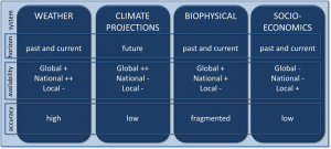
Four types of climate monitoring systems and their time horizon, availability and overall accuracy

The Climate Change and Adaptation Initiative (CCAI) is a collaborative regional effort of MRC Member Countries (Lao PDR, Cambodia, Thailand and Vietnam) to support processes of adapting to the new challenges posed by climate change in the Lower Mekong Basin (LMB). The main focus is a basin wide integrated approach to adaptation planning consistent with Integrated Water Resources Management principles and within the Framework of the 1995 Mekong Agreement. The specific aim is to make adaptation a permanent part of development plans and planning process, and to have tools as well as institutional and specialist capacity in place to implement them.

Rice harvesting

The CCAI focuses on the following Outcomes: (1) climate change impact and vulnerability assessment, adaptation planning and implementation in priority locations within the LMB; (2) building knowledge and capacity at different levels (institutional, technical and managerial capacity); (3) regional adaptation strategy supporting national frameworks; (4) regional partnership and collaboration. Currently, the CCAI is developing its first “Status of Climate Change in the Lower Mekong Basin” report. An important component of the Status Report will be the impact of climate change on the agricultural sector and the projected food situation in the LMB.

Analyses on changes in crop production and food demand and supply have clear transboundary dimensions. Changes might be important in the context of imports and exports of agricultural products. Irrigation is an important consumer of water and changes in irrigated areas can have basin-wide consequences. A clear overview of expected changes in crop production and food demand and supply in the LMB is missing. Earlier initiatives are restrictive in terms of: local specific, encompassing only climate change, often based on old climate scenarios, and, most importantly based on different and not comparable approaches and assumptions.

Mekong Delta

FutureWater will contribute to the before mentioned report, by providing an explorative outlook on crop production under climate change, and on food requirements and production under climate change. The analsyis will be carried out for the 15 principal sub-basins of the Lower Mekong Basin, and for three future situations (foreseeable, long-term and horizon).