The study will focus on selection of key traded crops between the EU and Africa and their key producing regions. The tasks will include overall analysis of current practices and the background in the regions, determination of key sensitive parameters in order to select key crops and food products and map hotspot regions. In addition, project team will assess climate risks for these hotspots on key crops and food products and link these risks with the importing countries. Climate risks will be assessed by identifying the multiple climate sensitivities on the food systems in each region, assessing changes predicted by a CMIP6 (latest) climate model ensemble on key agriculture-related climate indices, and analysing impacts on production-related indices, distinguishing between rainfed and irrigated production systems. It will be focused on country specific case studies in each partner country. The impacts of climate change on trade patterns will be evaluated to assess the carbon- and water footprints and virtual water profiles of key traded commodities of these countries. At the end, the project team will focus on policy relevance and assessment of adaptation strategies and identify interventions that will be needed, at which point in the system, and from which sector (or actor) is of interest.

The outcomes of CREATE will be used to increase awareness of the risks that climate change poses to the agro-food trade and the broader economy at large. They can contribute to efforts by the governments (macro-scale), the communities (meso-scale), as well as relevant agricultural producers (micro scale) in the case study countries, by providing essential information for promoting actions towards mitigating the negative consequences of climate change on agro-food trade.

This MIT feasibility project investigates the opportunities of an innovation project for determining the biomass potential from local nature management and green maintenance using the publicly available Lidar point cloud of the Netherlands.

The results of this feasibility project may lead to an innovative logistics support service where producers and consumers who play a role in the local biomass chain (e.g. nature management organizations, regional governments, energy producers) are provided advice and insight in the stock and availability of local woody biomass suitable for district heating projects or other local energy projects and biobased applications.

In the planned development path, a prototype of this service will be developed, demonstrated, tested, and validated for a pilot area. Using segmentation and classification algorithms, individual trees will be identified and tree-specific parameters relevant to biomass determination will be extracted. The economic perspective and market potential will also be investigated and relevant literature will be reviewed.

With a total annual turnover of approximately 500 million euros, the Netherlands is a major player in the production, import and export of fruits. In spring, when the night temperature drops below freezing point and fruit trees are flowering, fruit growers must protect their crops. If the flower buds were to freeze then no fruit is formed, resulting in enormous economic losses. Protecting the buds is usually done with the help of water, which requires an average of 30 m3 of water per hectare per hour. If several nights of frost occur the limit on water availability can be reached quickly. Moreover, if the quality of the water is not sufficient (e.g. due to salinity), the water can also cause damage to the crops. As a result, about 30% of the fruit companies in the Netherlands cannot use water for frost protection.

As an alternative to using water, wind machines to protect fruit trees against frost is emerging as a promising new and innovative technique. The propeller of the wind machine mixes the cold air with the higher, warmer air and can thus raise the temperature on the ground by several degrees. This feasibility project explores the opportunities of an innovation project for monitoring the effectiveness of wind machines for frost protection in fruit cultivation using flying sensors (drones) equipped with a thermal thermal imager. The results of this feasibility project may lead to an innovative information service intended for fruit growers to:

  1. Provide insight into the effectiveness of wind machines for frost protection as a cost-effective and sustainable alternative to spraying water. This service can target growers who already use wind machines and want to know how effective wind machines provide protection against night frost, but also growers who are considering wind machines and want to know to what extent the application can be suitable for their field.
  2. Advise how the application of wind machines can be optimized in the business operations of fruit companies. This includes optimal placement of the wind machine in the orchard and whether the wind machine is properly adjusted for the type of fruit being grown. This relies on what rotational speeds are needed for a given temperature increase, at what angle the propeller should be aimed, etc.)

A prototype of this service will be developed and demonstrated for a pilot area through a development process. An important part of the development trajectory is research into and development of a:

  1. State-of-art interactive visualization tool to visualize spatial information within a
  2. (beta) web application such as a dashboard to offer the innovative information service to the end user (fruit grower).

The power of flying sensors with thermal imaging cameras is that the temperature-increasing effect of wind machines can be measured very precisely and can also be mapped spatially. This visual information can provide the fruit grower with insight and confidence that wind machines are effective for frost protection.

The purpose of these calculations was to provide a definite answer about the usefulness and necessity of the proposed storm water retention areas that were seen as necessary in 2009. Various scenario calculations were performed using a Sobek model in which water levels and discharges were compared under the current and future climate and with and without integration of the storm water retention areas.

The activities in this project included:

  • Testing of discharge and water levels at critical locations for the climate scenario at different recurrence times (flood risk assessment using climate scenario),
  • Comparison to the results of the flood risk assessment using historical climate data,
  • Integration of storm water retention areas in the Sobek model and analysis of their impact on water levels, discharge  at critical locations (usefulness and necessity for storm water retention areas, answer to LBW),
  • An initial estimate of critical locations along specific flood defense barriers for the different scenarios (high resolution comparison of water levels and defenses barrier heights) and
  • A comparison of the results with a number of previously conducted studies.

During the project, the flood risk assessment method, which was developed by Arcadis in 2020, was (further) automated, so that the method can be applied more quickly and for other comparable projects within Vechtstromen Water Board. Based on the results of the calculations, clear advice could be given on the usefulness and necessity of the proposed storm water retention areas as they were proposed in 2009.

More information about the method for standardizing regional flooding that is used by the Vechtstromen Water Board can be found on the following website (in Dutch): https://www.vechtstromen.nl/over/klimaat/wateroverlast/normering/werkt-normering/

Hydropower is essential to fulfill future energy demands. Water scarcity is likely to increase due to climate change and aase in water demand. Therefore, Climate Risk Assessments are required before large investments in new and large hydropower stations (>100 MW) are made. Small hydropower (1 – 20 MW) does not require these Climate Risk Assessments yet, but this will eventually happen in the future. Investors are highly interested in the profitability of these small hydropower stations, especially because of the uncertainty caused by future climate change. Current methods for Climate Risk Assessments (CRA) are however still too costly for these small-hydro projects because they are very labor intensive and require specific knowledge.

FutureWater has carried out a feasibility study to assess the possibilities for the development of a “Small-Hydro Climate Risk Assessment tool” (SH-CRA) that can make CRA’s for small-hydro projects cost effective. The starting point of this project to develop the SH-CRA is the recent change in the approach to CRA’s: until a few years ago, these were based purely on climate models, also known as the “Top-down” approach. Nowadays however, investors require a more pragmatic approach in which climate risks are balanced against other risks and presented in a clear way. This new “Bottom-up” approach makes it possible for small-hydro projects to include climate risks in the investment decision.

This feasibility project has therefore investigated whether the “bottom-up” climate risk analysis approach can make it possible to develop such a SH-CRA solution, based on a combination of literature research, an inventory of available technology and potential partners, and competition analysis.

A large Dutch consortium has joined in the project “Dutch network on small spaceborne radar instruments and applications (NL-RIA)”, led by TU Delft. The objective is to bundle the radar-related knowhow available in The Netherlands, and fill the knowledge gaps, in order to boost SmallSat radar-based Earth Observation technology. The focus of the project is on microwave remote sensing.

A key advantage of microwave remote sensing compared to optimal imagery is the all-weather/day and night observation capability, which greatly enhances the observation opportunities. This includes the ability to observe through clouds. Microwave remote sensing system include passive (radiometers) and active ones (radar altimeters, Synthetic Aperture Radars, precipitation radars, scatterometers, etc). This study will focus on altimeters and thus on active radar.

Continuous monitoring of fresh water bodies like rivers, lakes and artificial reservoirs, is important for water resources management, and thus for the principal water users in river basins, such as domestic, industrial and irrigation demands. Also, potentially there can be applications of this information for flood early warning, renewable energy (hydropower) and for the transport sector (shipping).

For the management of fresh water resources at the basin level, information on the status of surface water bodies is critical. In many areas in the world however, this information is scarce. Especially in developing countries, water level measurements of lakes and reservoirs are hardly available. In Europe, ground-based measurements are more common but sometimes performed by the entity operating the reservoir or river abstraction, and thus not available to water resources managers for the purpose of water resources planning. Also in transboundary (international) river basins, ground-based information is often not shared, so satellite-based information can be of high value for certain end-users (Zhang et al., 2014).

Altimeter measurements of rivers, lakes and artificial reservoirs and be used for two purposes:

  • Strategic planning of water resources, which requires water resources assessments to support for example river basin management plans
  • Operational management of water resources, for example for the hour-by-hour operational management of water release from reservoirs for hydropower.

The study performed by FutureWater focused on the first type of applications: strategic planning and decision making on the long-term. Especially for this purpose, satellite-based altimeter data has the potential to fill an important information gap. For the second type of applications: operational water management and short-term decision making, typically ground-level water level sensors are more cost-effective than satellite-based solutions.

Key results

From the analysis performed by FutureWater and based on literature review, the following key considerations are proposed for shaping a low-cost altimetry mission useful for assessing inland water bodies and water resources planning:

  • Altimetry information can be extremely useful for complex systems as for example swamps, where data on surface water levels and flows are scarce, as often the case in developing countries. Altimetry data can support the management and conservation of these systems that provide key ecosystem services for people and the environment.
  • To build hydrological models for water resources assessments, historic data is required to calibrate and validate the tools. To capture the variability in water resources systems and thus perform a successful validation, a period of around 10 years of altimetry data is recommendable.
  • A revisit frequency of 1 month is typically sufficient for water resources assessments. Higher frequencies are normally not necessary as they may only lead to minor improvements in the performance of the modeling tools. Lower frequencies (e.g. two months) are not sufficient to capture the seasonal pattern adequately.
  • The required accuracy is highly dependent on the characteristics of the water body and is a function principally of the annual dynamics in storage, and the depth-storage relationship. In case study I, with a very large but shallow water body, an accuracy of approx. 10 cm was considered necessary. For case study II, with a smaller and deeper water body, it was found that up to an error of 180 cm the performance of the model was not significantly affected.
  • The accuracy requirement can possibly also be expressed as a percentage of the annual variability in water levels, of a particular water body of interest. For example:
    • In case study I, annual increases of approximately 1 m are common. The accuracy requirement is approximately 10% of this (10 cm)
    • In case study II, water level increases or decreases within a year of around 15 m are possible. Also here, the accuracy requirement is in the order of 10-15% of this annual variability.
  • Finally it has to be noted, that the usefulness of the altimetry data is also dependent on the availability and quality of other datasets necessary for the hydrological modeling. These datasets are primarily the depth-volume relationship, ideally from in-situ measurements but possibly extracted from satellite data (Duan and Bastiaanssen, 2013b); as well as discharge data upstream or downstream of the water body. Without these data sources it is not possible to establish a reliable water balance of the water body.
The development of high-end electrical sensors has taken a boost over the last few years, and staying up-to-date is therefore a must. Within the east of the Netherlands, several SMEs and knowledge institutes luckily have a strong position in the development, production, and commercializing of sensor systems, their components, and required technologies. The Management Authority OP Oost from the province of Gelderland provides financial support to bring the development and commercialization of innovative sensor systems from TRL4/5 to TRL6/7.

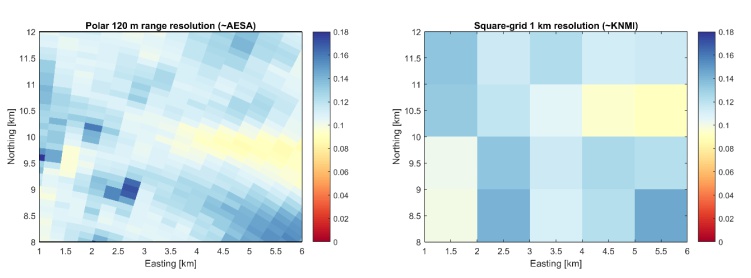
Difference between high-resolution AESA radar (left) and KNMI radar (right).

Within the first DAISY project the TRL4/5 of the DAISY concept was demonstrated. We demonstrated that this compact and mobile sensor system has the potential for several socio-economic applications, being security, transport and logistics, life-sciences, and agro-food. DAISY 2 builds on the success of the first DAISY project, and aims to further develop this sensor system and explore the viability of this sensor product for different markets.

The DAISY 2 consortium is led by Thales Nederland B.V., and consists of the following consortium members: NXP, TNO, Sencio, Salland Engineering, Sintecs, Noldus, VDM Kunststoftechniek, Etchform, FutureWater, and the Hydrology and Quantitative Water Management Group (HWM) of Wageningen University. During this 3-year project we aim to bring the development and commercialization of this sensor product to a Technology Readiness Level (TRL) 6/7. Within this project FutureWater will work closely together with the HWM group of Wageningen University to further develop and explore the viability of this AESA sensor for the meteo-hydrological forecasting and water-for-food market.

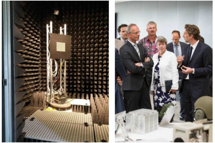
Presentation of the DAISY concept (left) to Mr. Kamp, Minister of Economic Affairs (right).

Climate change will likely influence the concentrations and loads of contaminants in and towards ground- and surface waters. To have a better understanding on the effects of climate change on contaminants in the hydrological system, a consortium was formed a few years ago, consisting of the National Institute for Public Health and the Environment (RIVM), Utrecht University, VITO (Belgium), and ALTERRA. The project was entitled as “Climate Cascades”, which represents interrelated processes that occur as a result of climate change, and the influences of these processes that are exerted on man and ecosystems.

In the project “Climate Cascades”, Utrecht University adopted the task to develop a “River Basin Model” aiming at simulating the climate change-induced changes in catchment-scale heavy metal and pathogen concentrations and loads. The “River Basin Model” has been developed by implementing and applying a conceptual lumped hydrological model, called WALRUS (Wageningen Lowland Runoff Simulator), in a semi-distributed way. For the implementation and application of the model the catchment of the Dommel River (i.e. located in the border region of the Netherlands and Belgium) was selected as study area. Subsequently, a metal transport module was coupled with the hydrological model in order to simulate Cd and Zn concentrations and loads in ground- and surface water. Following the coupling between the hydrological model and the metal transport module, a pathogen transport model was coupled with the hydrological model in order to simulate the transport of Campylobacter and Cryptosporidium from land surface and sewage to surface waters.

The outcomes of the studies as mentioned above were and are reported by means of scientific publications. The aim of this project is to finish two papers that were initiated at the Utrecht University. The first paper focussing on the effects of climate change on metal transport has already been submitted and is currently in review. The second paper focussing on the effects of climate change on pathogen transport is in development and has to be submitted. The main aim of this project is to finish these papers and to guide them to publication in a peer-reviewed journal.

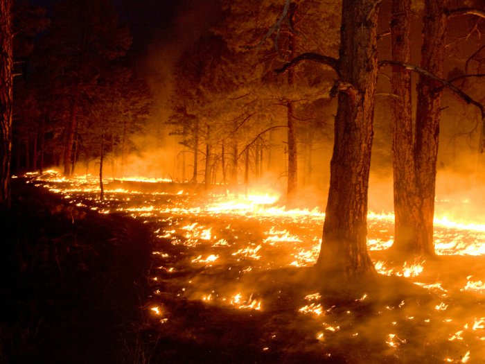
Several large wildfires have taken place in The Netherlands in recent years. Although the affected surface area is small in comparison to other countries, the societal risk is substantial due to the intensive use of natural areas for recreation, tourism, timber production, military practice, etc. In addition, high-risk vegetation is often located adjacent to highways, railway tracks, installations for drinking water supply and built-up area. The “Natuurbrandverspreidingsmodel” (NBVM) of the IFV plays an important role in mitigating wildfires. The model predicts the expansion of a wildfire through time and is used for risk analysis in a preliminary phase, as well as for decision support during the occurrence of a fire.

Despite the fact that the NBVM strongly depends on spatial information, currently only a topographical map is used as input in addition to weather predictions at the point scale. The project “Using satellite data for wildfire mitigation” will yield a product that achieves a significant improvement in the spatial representation of environmental factors relevant to the NBVM. The Wildfire component of the SVIPE product (Satellite-based Vegetation Information PackagE) will contain dynamic map layers that can be used as model input. Generic, up-to-date map layers of a large number of important parameters in the process of wildfire expansion will come available for all national parks in The Netherlands. Based on this information, it is foreseen that the performance of the NBVM will improve, both in terms of general risk analysis as well as simulating wildfire expansion. When both firefighters and managers of nature areas make use of this product, this will enhance cooperation in mitigating risks and mutual action at the time of fire hazards.

After a successful first phase, in which the technical and financial feasibility of SVIPE-W has been established, a second phase has now started in order to develop a full prototype. In this phase, the methodology will be fully automated and standardized, and by means of a fieldwork component the algorithms will be trained and validated in more detail. The end result of this project is a product that provides monthly spatially distributed information on fuel type, vegetation density, and moisture content in nature areas.

There are strong indications that the risk of infection in humans with Q fever depends on physical environmental factors such as warm weather with dry soils and a certain wind. Wind with enough speed and the right direction can bring out dust particles in the air that bacteria capture. These can then be inhaled by humans and animals in the surrounding area. It is believed that aerosols can move several kilometers by wind in dry, dusty conditions. Q fever outbreaks in humans took place in the Netherlands in 2007, 2008 and 2009, increasing in size.

The magnitude of the outbreaks in the Netherlands indicates that the transmission occurs through large scale pollution or by the existence of multiple contaminated point sources, and not so much by direct (professional) contact with animals or for example consumption of contaminated unpasteurized milk. So far, conclusive evidence is lacking to what factors influence the risk of infection the most. In some infected farms little or no infection is detected in humans while other sources have passed over to humans; regardless the size of the farm.

All this raises the question of whether physical environmental factors in certain areas of infection were more conducive for transmission than elsewhere. In this study, the influence of these factors, soil type and, in particular, usage and humidity are examined, taking into account the population density, company size, production methods and weather conditions.