
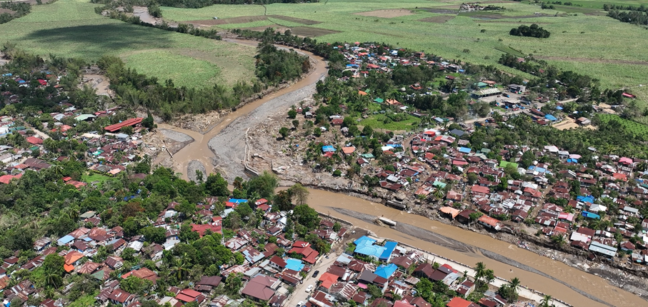
Negros Occidental is regularly flooded along its river basins, and recent (super) typhoons such as Tino caused widespread damage. The provincial government and its local government units (LGUs) want to move from reactive response toward planning and prevention, but that requires a clear, shared picture of where floods happen, what is exposed and who is most vulnerable.

The province already holds a strong data foundation, including a high-resolution elevation model, national flood hazard maps and a capable GIS and drone unit within the Provincial Planning and Development Office. What was missing was a structured way to combine these datasets into one consistent flood risk picture, and the in-house capacity to keep building on it.

Chris Hurink joined an intensive in-country DRRS deployment and worked alongside the provincial GIS team. The work was organized around the three components of flood risk. For exposure, the team updated building footprints and added commercial, industrial and energy sites, plus critical infrastructure such as roads and bridges. For hazard, it started the flood hazard analysis, quality-checked the available flood layers and validated them in the field. For vulnerability, it processed Community-Based Monitoring System (CBMS) census data and linked it to the building footprints. Throughout the week, hands on training in remote sensing, Google Earth Engine and good data practice strengthened the team’s skills, using automated tools wherever possible.

With improved datasets, a clear roadmap and a better-equipped GIS team, the Province of Negros Occidental is better placed to carry out a province-wide, impact based flood risk assessment and to use the results for planning, early warning and prioritizing investments, so that its inhabitants are better prepared and protected against future floods.
Negros Occidental

FutureWater had previously tailored the REWEFe toolkit to the regional WEFE Nexus context and demonstrated its application for selected river basins. Building on this work, the April 2026 training aimed to strengthen regional capacity for using REWEFe as a decision-support instrument within basin planning and governance processes. Participants included representatives from national and local governments, IRBM Learning Centers, partner universities, and national coordinators from the participating ASEAN Member States.

The training combined technical and governance-oriented learning. FutureWater introduced the structure, data requirements, scenario setup, and interpretation of the REWEFe toolkit, while guiding participants through hands-on exercises to analyse baseline conditions, develop scenarios, and interpret WEFE-related synergies and trade-offs. The sessions placed strong emphasis on translating policy plans and sector strategies into structured quantitative scenarios, enabling participants to better connect analytical outputs with planning, investment, and policy dialogue.

The governance component was delivered in collaboration with Dipankar Aich, who contributed expertise on IRBM governance, WEFE Nexus thinking, cross-sector coordination, and the science–policy interface. His sessions supported participants in understanding how REWEFe outputs can be positioned within governance processes, policy dialogues, and decision-making cycles.

Through this assignment, FutureWater contributed to strengthening the practical uptake of REWEFe in Southeast Asia by linking technical modelling, scenario analysis, and governance processes. The training supported participants in using the toolkit not only as an analytical model, but also as a structured approach for dialogue on water, energy, food, and ecosystem trade-offs in river basin planning.

The GEF / UNDP / ASEAN Project on Reducing Pollution and Preserving Environmental Flows in the East Asian Seas through the Implementation of Integrated River Basin Management (IRBM) in the ASEAN Countries is a 5-year project (2023-2027) with the goal of establishing functional IRBM mechanisms in seven priority river basins / sub-basins / watersheds in six ASEAN Member States, to reduce pollution, sustain freshwater environmental flows and adapt to climate change vulnerabilities. The Project is designed to improve governance and management arrangements in IRBM and accelerate the required changes in the six AMS in support of national priorities, objectives and commitments to global sustainable development targets using the Source to Sea (S2S) framework. The PEMSEA Resource Facility (PRF), which serves as the Project Implementing Partner, hosts the Regional Project Management Unit (RPMU). It works in collaboration with National and Local Government Partners and River Basin Organizations.

Component 1 of the Project focuses on the conduct of a baseline assessment of the S2S management continuum with a targeted outcome of improving understanding of governance, socioeconomic, ecological conditions, gaps and needs of priority river basins / sub-basins and coastal areas. This will be achieved through the establishment of the State of River Basin (SORB) reporting system to consolidate information coming from administrative, social, economic and environmental sectors. As an input to the SORB baseline reporting, it is required to complete a comprehensive assessment of competing uses and users of water as a consequence of existing and future water uses and their implications on the water / energy / food / ecosystem (WEFE) security nexus in the priority river basins.

FutureWater is providing this assessment of the WEFE security nexus through review of existing knowledge and literature, stakeholder consultations, as well as tailoring and applying its REWEFe toolkit for nexus analysis to seven river basins in six countries of Southeast Asia: Cambodia, Indonesia, Lao PDR, Malaysia, Philippines and Viet Nam.

Countries in Asia and the Pacific region are significantly exposed to disaster risks from various hazards and are on the frontline of a climate emergency. Studies suggest that 80% of the globally affected people belong to the Asia-Pacific region, thus emphasizing the critical need for an effective multi-hazard EWS.

EWS, a cost-effective tool for saving lives and reducing economic losses, is particularly crucial for frequent and hazardous weather, water, and climate events. However, despite advancements in the four EWS components, major gaps persist, with implementation lagging and limited coverage in frontline countries, including least developed countries (LDCs) and small island developing states (SIDS). As of 2021, only 50% of countries in Asia and the Pacific reported having multi-hazard early warning systems (MHEWS), emphasizing the need for support.

The culmination of these efforts will be encapsulated in a scoping report, documenting the results of the project, including consultations with key partners and stakeholders during the Regional Workshop on Increasing Investments in Early Warning Systems, to be held in February 2024 in Bangkok, Thailand. The study will offer a comprehensive summary of the EWS scoping, encompassing the policy and institutional landscape, status, initiatives, and investments, as well as residual gaps for regional and national EWS programming in selected DMCs. Additionally, this study will provide guidelines for the implementation and operationalization of the proposed EWS facility, along with initial investment concept notes based on EWS priorities at regional and/or national levels. This holistic approach aims to contribute substantively to the strengthening of EWS capacities, fostering resilience in the face of increasing disaster risks across the region.

The Ridge to Coast, Rain to Tap: Sustainable Water Supply Project (R2CR2T) is an integrated approach to addressing flooding in the Cagayan River basin on Mindanao in the Philippines. R2CR2T is a Public Private Partnership led by VEI together with the partners COWD (Cagayan de Oro Water District), FITC, UTPI/Hineleban Foundation Inc. (HFI), Philippines- and Netherlands Red Cross, Cagayan de Oro River Basin Management Council (CDORBMC), and Wetlands International. R2CR2T is funded by RVO through the Sustainable Water Fund programme.

The Cagayan River Basin is characterized by an upstream mountainous area with steeply sloping terrain towards downstream Cagayan de Oro city. Upstream deforestation and land degradation are known to increase risk of flooding in the city, which is at present already at a high level. One expected outcome of R2CR2T is to have an enabling environment for stakeholders, both private and public sector, to undertake activities related to sustainable land management in the Cagayan River Basin. A Decision Support Tool (DST) for identifying critical areas and approaches for rehabilitation and its benefits regarding flood risk reduction, soil erosion reduction, and enhancing dry season flows, will be developed based on a scientifically-sound hydrological model for the watershed of the Cagayan River.

FutureWater was hired to advise on the development of the DST and hydrological model, critically review the quality and applicability of (intermediate) outputs by the local team and their service providers, and provide an external and international ‘helicopter view’ on the eco-hydrological aspects of the project. In a general sense, FutureWater supports the R2CR2T project team to maximize the impact of the DST will have for the CDORB region and stakeholders.