Most recent research has focused on identifying historical megadroughts based on paleo-records and understanding their climatic causes, or on the study of “modern” events and their impacts, generally in lowland and plain regions. However, high-mountain regions and snow-dependent catchments have been little studied, and little is known about the impact of megadroughts on the state and dynamics of the cryosphere in mountain water towers.
In general, catchments dependent on high mountain systems have an intrinsic capacity to buffer the lack of precipitation and excess evapotranspiration that depends on the water reserves stored in the cryosphere (snow, glaciers and permafrost). It is presumed that the this buffer capacity is limited until a tipping point is reached from which the impacts of water shortages and temperature extremes may be amplified and jeopardize the functioning of ecosystems and water resource systems.
Megawat has a double objective: 1) to address the knowledge gaps around the hydro-climatic causes of extreme droughts and their impact on the water balance of Europe’s mountain water towers, with special emphasis on the concurrence of compound events and cascading and multi-scale effects and 2) to develop and propose new adaptation strategies to cope with the duration, extent and severity of future megadroughts and their potential impacts on environmental and socio-economic assets.
For its implementation, MegaWat focuses on Europe’s high mountain regions and their dependent-catchments. MegaWat aims to develop three products:
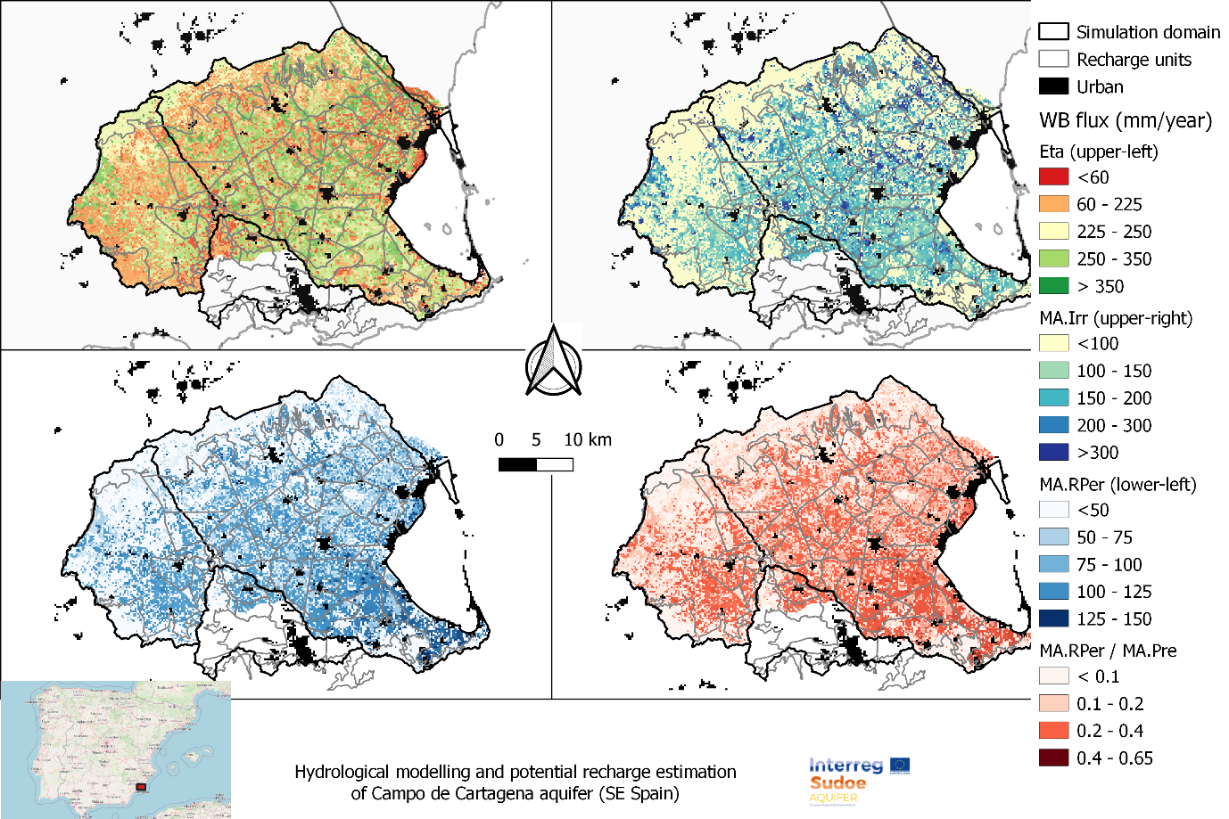
- Product 1. A methodological framework for the identification and characterization of historical megadroughts during the instrumental period, and the assessment of the role of the cryosphere in supporting the landscape development of downstream areas, or in buffering climate change impacts. Product 1 relies on a combination of climate regionalization, surface energy balance modelling, hydrological simulation, and water evaluation and allocation analysis at the catchment level (figure below).
- Product 2. A high-resolution, open-access regionalized climate database.
- Product 3. A list of potential adaptation strategies useful for the prevention and mitigation of drought impacts, and the enhancement of the water security and resilience of high mountain regions and dependent catchments. These scenarios will be agreed with regional and local actors and stakeholders, and their effectiveness will be evaluated under extreme drought scenarios in three pilot regions in Europe. These pilot regions will be previously selected following criteria of representativeness, strategic importance and vulnerability to droughts.

FutureWater plays an important role in MegaWat by coordinating the Work Package which aims to develop and test simulation tools that help to adapt to megadroughts and support the decision making process. Two specific objectives are pursued in this Work Package: a) the development of a methodological prototype for quantifying impacts and identifying tipping points for water security in snow-dependent downstream catchments, and b) the generation and the integration of snow drought indicators in the FutureWater’s Drought Early Warning System called InfoSequia (figure below).

A one-pager can be downloaded here.
Acknowledgements
This project has received funding from the Water4All programme with co-funding from CDTI (Spanish Office for Science and Technology) and the EU’s Horizon Europe Framework Programme for Research and Innovation.