The TU Delft and TAHMO (Trans-African Hydro-Meteorological Observatory) have launched a project with the Netherlands Embassy in Ghana to improve local weather data, help Ghanaian farmers get actionable information from it and with it foster a climate-smart horticultural sector in Ghana. At FutureWater, we support the project by researching optimal planting dates for horticultural crops that are commonly grown in Ghana, such as tomato, eggplants, and onions. The end goal is to supply farmers and extension officers with location-specific information on optimal planting dates for different horticultural crops.
Our methodology is inspired by earlier work led by TU Delft. The FAO AquaCrop model is used simulate crop growth and yields under different possible planting dates based on data of the local climate and local soil conditions, considering the spatial variability across the country. Different planting strategies are analyzed, to assess the effectiveness of both traditional and weather-data informed planting strategies. FutureWater uses the open-source Python version of AquaCrop, developed by Manchester University.
This project will not just explore new ground on sowing windows in Ghana, but it will also provide actionable information for Ghanaian farmers and help them better prepare for an already changing climate.
The BUCRA (Building Unity for Climate Resilient Agriculture) project focuses on enhancing agricultural resilience in Qahbunah, a farming community in Egypt’s Nile Delta. Facing challenges like water scarcity, climate change, and land fragmentation, local farmers require innovative approaches to sustain their livelihoods.
At the heart of BUCRA are two cutting-edge tools developed by FutureWater: Croptimal and SOSIA, which combine advanced technology with local insights to transform traditional farming practices.
Croptimal is a climate suitability analysis tool that leverages climate projections, geospatial data, and agricultural insights to assess the suitability of various crops under current and future climate scenarios. By identifying areas and crops that are most resilient to climate stressors like heat, salinity, and water scarcity, Croptimal empowers farmers with data-driven recommendations to optimize their crop choices and planting strategies. This tool provides highly detailed maps and actionable advice, enabling farmers to adapt their practices to the challenges of climate change while enhancing productivity.
SOSIA (Satellite-based Open-source Irrigation Advisory) is an irrigation management tool designed to improve water use efficiency. It uses open-source satellite data, real-time weather information, and local soil conditions to provide precise daily irrigation advice. Farmers receive recommendations on how long to irrigate their crops each day via WhatsApp, making the service both accessible and cost-effective. This innovative approach not only reduces water usage but also improves crop yields and energy efficiency, addressing the increasing pressures on water resources in the Nile Delta.
In addition to these tools, BUCRA includes demonstration plots showcasing climate-smart techniques such as efficient irrigation, soil management, and crop rotation. Farmers will also participate in a blended learning program that combines field-based training with easy-to-use digital applications to improve their technical skills and knowledge.
BUCRA emphasizes empowering youth and women in agriculture, strengthening market linkages, and promoting sustainable land-use practices. By aligning Dutch expertise with local needs, the project aims to boost productivity, stabilize incomes, and build a sustainable agricultural future in Qahbunah.
The long-term vision is to inspire broader adoption of these tools and practices, ensuring food and water security in the region while addressing the challenges posed by climate change.
The UNDP is implementing the project “Conservation and sustainable management of lakes, wetlands, and riparian corridors as pillars of a resilient and land degradation-neutral Aral basin landscape supporting sustainable livelihoods” to enhance the resilience of the ecosystems and livelihoods in Lower Amudarya and Aral Sea Basin (LADAB) through land degradation neutrality (LDN) compatible integrated land-water management.
This assignment contributes to water allocation analysis and the development of water supply scenarios for irrigated agriculture and biodiversity conservation reports. The services consist in:
Consulting with project experts, government agencies, local communities, and other relevant stakeholders
Develop a hydro-economic water allocation model for the lower Amu Darya basin using WEAP
Explore different scenarios for irrigated agriculture and biodiversity conservation, considering climate change, to strike a balance between sustainable agricultural practices and conservation of biodiversity and ecosystems and (iv) build capacity and support project experts and relevant stakeholders on water allocation analysis and modelling.
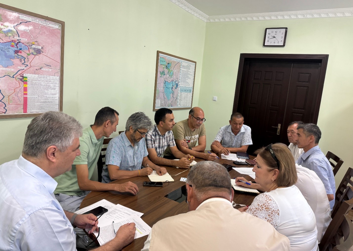
Stakeholders consultation in Nukus, Uzbekistan
Analysis of the historical climate data and future model projections indicates significant shifts in rainfall patterns. These shifts could influence water availability within the upstream river basins, which are vital for irrigation practices and ecological balance. Furthermore, the study explores variations in temperature -including average, minimum, and maximum values- and evaluates their potential consequences on water demand due to increased evaporation rates and altered crop water needs.
Additionally, this scoping research touches upon the effects of these climatic factors on olive crop phenology and productivity. The study also considers the likelihood of extreme weather events, such as heatwaves and droughts, and their potential to disrupt traditional farming cycles and water resource management strategies.
The outcomes of this analysis are aimed at providing an olive producing firm with insights and strategies to mitigate the adverse effects of climate change on olive production in these targeted regions of Andalucia. By foreseeing potential challenges and preparing for them, a decision can be made on whether to invest or not in order to maintain a leading olive producer on the global stage.
To achieve the objectives the project has a technical component and stakeholder engagement component. On the technical side, hydrological models will be updated and validated. Climate change scenarios will be used as inputs for the testing of adaptation strategies within the Limpopo Basin. The adaptation include traditional grey infrastructure and additionally nature based solutions. The benefits analysis of the adaptation measure will cover macro and micro socio-economical benefits.
The results of this study will then be used to inform the development of a first-generation Transboundary Diagnostic Analysis (TDA) for the Limpopo River Basin (LRB). Through this, the individual basin countries will agree on a set of transboundary development priorities for the basin, which will guide both transboundary and national investments in the future, through a Strategic Action Plan (SAP) and National Action Plans (NAPs).
This consultancy project is framed by the AQUIFER project, “Innovative instruments for the integrated management of groundwater in a context of increasing scarcity of water resources” (Interreg-SUDOE V programme) which aims to capitalize, test, disseminate and transfer innovative practices for the preservation, monitoring and integrated management of aquifers.
FutureWater expertise was required for providing a novel and open-source hydrological modelling framework able to quantify spatial patterns of daily root percolation as a direct surrogate of groundwater recharge in the Campo de Cartagena Quaternary Aquifer (CC-QA). This aquifer is located at SE Spain and is one of the most important vectors of water drainage to the Mar Menor lagoon.
This task is addressed through the improvement and local calibration of the SPHY code for the Campo de Cartagena and the simulation of the water balance in the soil root zone from the 1950s until the end 2020. The SPHY-Campo de Cartagena includes a new routine able to compute irrigation inputs at the pixel level based on satellite data. Timeseries of monthly root percolation are taken as good surrogates of potential groundwater recharge and used as the main forcing input to an hydrogeological model of the Quaternary aquifer. The calibration process is performed through a sensititivity-intercomparison analysis in which model-derived outputs (irrigation and streamflow) during the calibration period are cross-checked against actual observations.
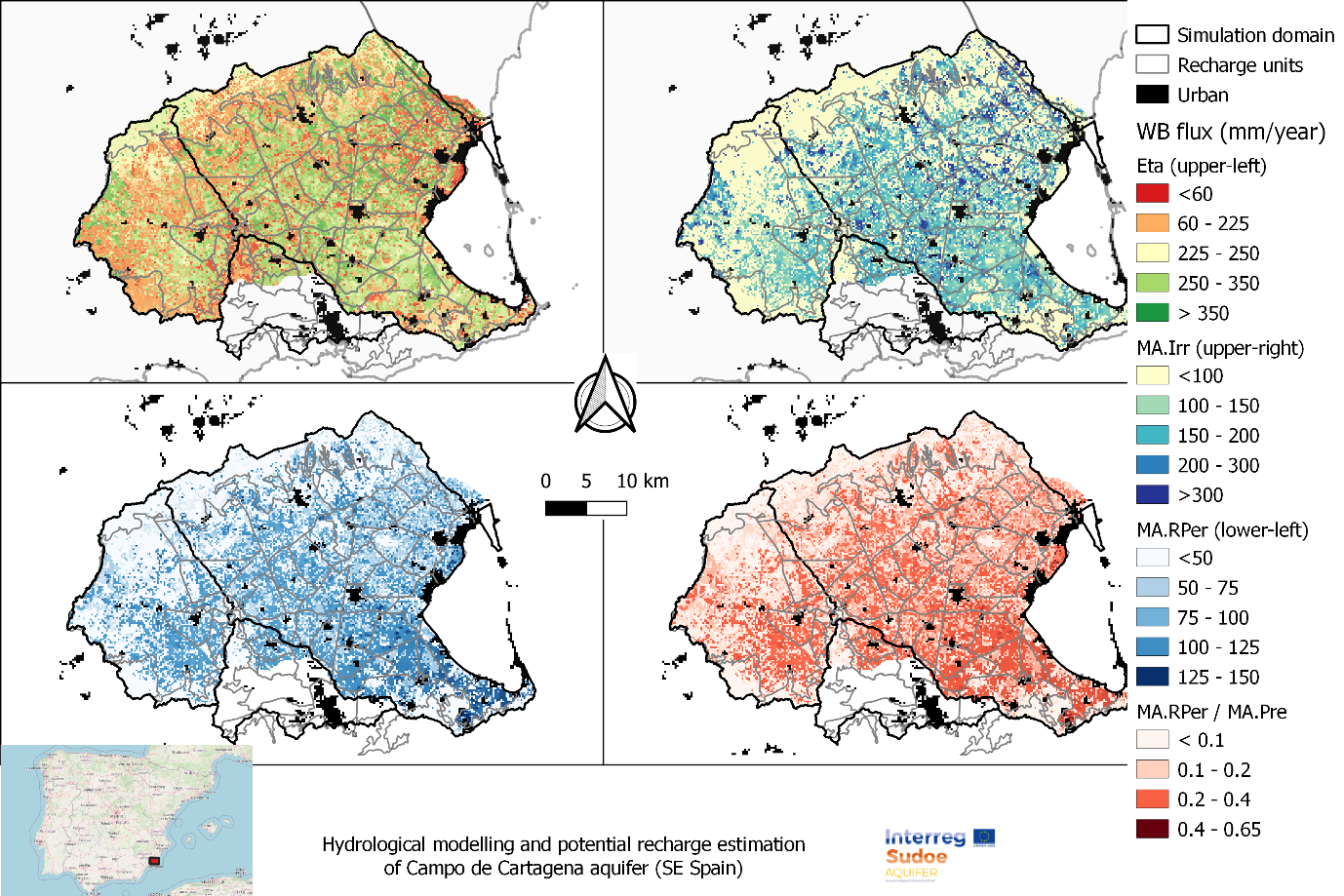
Spatial patterns of root percolation and the relative contribution of irrigation return flows to the total groundwater recharge were quantified (e.g. Figure 1) under historical and current conditions. Simulation results would show the lack of a significant temporal trend in the long-term recharge rates in the aquifer, most likely due to the the strong interannual variability observed in rainfall patterns, but also by the trade-offs resulting from the combination of climate, land use and irrigation-crop management drivers.
Figure 1. Mean Annual values of the main water balance components in Campo de Cartagena (2000-2020). RPer_ratio refers to the fraction between Root Percolation (MA.RPer) and Precipitation (MA.Pre)
FutureWater supports Fiera Comox in its due diligence process for the acquisition of a vertically integrated tree-fruit operation in North Spain. Particularly, FutureWater addresses an overall assessment of the most important water-related factors of risk that may control the current and medium-term feasibility of the fruit orchard farming system of interest. The application of FutureWater’s approach applies a multicriteria analysis and allows to qualify the levels of risk for each key factor analyzed.
FutureWater’s approach rests on: 1) the collection and analysis of data retrieved from documents, large datasets, and in-situ field inspections and stakeholder interviews, and 2) the scoring of the risks previously identified based on a final expert judgment.
Key sources of information for this risk screening included:
Existing documentation, reports, plans, and local legislation that may affect the access to water for irrigation
Existing and publicly accessible spatial and GIS data, including satellite imagery and thematic datasets available through national and regional agencies and platforms (Ebro River Basin Authority, National Infrastructure of Geospatial Data, Spanish Information System of Water)
Meteorological data (rainfall and temperature) from nearby weather stations
Groundwater level from the Spanish National Ministry of Environment.
Private data and documents generated by clients and stakeholders through personal and follow-up communications with farmer
Key variables analyzed and evaluated at the district and regional scales, to the extent relevant to the farm, included:
Water availability of surface and groundwater resources. For groundwater, a trend analysis of water levels, and first-order assessment of quality constraints and risks is included.
Impacts of climate change on water resources availability based on rainfall and temperature trends and projections for the region.
Water quality for irrigation purposes.
Potential conflicts due to competition for water in agriculture and other sectors of activity.
Legislative and policy-related factors that may affect the overall performance were also analyzed risk-by-risk.
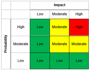
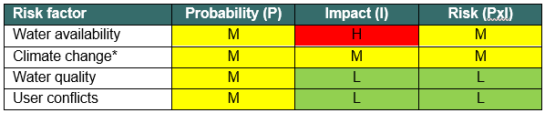
Four factors of risk were analyzed: water availability, climate change, water quality, and water conflict. Each factor of risk was scored according to a risk matrix in which levels of probability of occurrence and impact severity were qualified based on data and expert judgement. For each factor, a risk matrix with three levels of overall risk were adopted: Low Risk (L), Moderate Risk (M), and High Risk (H)
Figure 1. Overall risk levels when probability of occurrence and impact severity are qualified.Figure 2. Overview of risk assessment by factor.
In this particular project, the approach was implemented in four different settings located in the area.
The issue of water scarcity is intensifying across the Asia Pacific region, posing significant challenges for sustainable agricultural production and water resources management. The Water Scarcity Program (WSP), designed by FAO-RAP and partners, aims to bring agricultural water use within sustainable limits and prepare the sector for a productive future with less water. The program aims to assess the ongoing issue of water scarcity in the region, evaluate potential management options, and assist partner countries to implement adaptive management in the agriculture water sector using innovative tools and approaches.
As part of the WSP, FutureWater will design and deliver a two-phase water accounting training program in Indonesia, Vietnam and Thailand, respectively. The first phase of the training will primarily focus on introducing and better understanding the concept of water accounting, its components and approaches. Participants will also work with tools such as REWAS and Follow the Water (developed by FutureWater in collaboration with FAO) to conduct water accounting in agricultural systems at different scales. Through the use of these tools, participants will be able to estimate real water savings at system and basin scale, and also analyze the impact of different irrigation schemes on the overall water availability in the system. The second phase will consist of participants working on the selected basin in each country to develop a detailed water account. Given the data availability and accessibility issues in the region, the participants will learn how to access, process and analyse remotely sensed datasets using Google Earth Engine.
In addition to the trainings, FutureWater will also provide technical inputs for the regional WSP events on water scarcity and highlight the technical challenges of implemeting water accounting and allocation in south-east Asia for the WSP High Level Technical Meeting to be held in June 2024.
Looking at global climate change patterns and its increased pressure on natural resources, West African countries like Ghana will be hit very hard. In particular, agriculture, which is the largest water user in Ghana, will be affected by high temperatures and changes in the variability of rainfall. This variability in climate makes crop production and yield more uncertain, as well as farm income. The periods of droughts in Ghana are getting longer and there is increased pressure on water availability from the river basins due to climate change, putting many people and farmers in risk of having too little water. Therefore in this project, we will develop and pilot in the field an innovative tool that will significantly enhance water security in Ghana by reducing the quantity of water needed for irrigation per hectare (up to about 40% less of current water use).
To support the Ghanaian farmers in making the transition to a water secure future, they expressed a need for locally adapted, climate smart irrigation technologies and innovative advice to improve their irrigation practices. To develop such a smart irrigation service, FutureWater is working together with knowledge institute TU Delft, horticulture company Holland Greentech, and social enterprise TAHMO to develop this innovative tool and implement it in the field. This smart irrigation service should be able to translate various weather parameters and data (historical but also real-time data) into crop specific irrigation advice in volumes, but also in minutes for small-scale farmers. The unique and innovative part of this smart irrigation service, called SOSIA+ (Small-scale Open source, Satellite based Irrigation Advice), will be the algorithm to provide advice on how many minutes a farmer should irrigate a specific crop – based on the combination of the TAHMO local weather data and real-time data (normally not taken into account), that will be tailor-made for small scale farmers (normally these services are only for large scale farmers while the predominant type of farmers in Ghana are small scale) and is linked to the innovative drip irrigation systems that Holland Greentech Ghana already sells to farmers (so closely linked to an existing customer base of farmers and a product).
SOSIA+ will initially focus on the city of Kumasi and the Ashanti region, targeting more than 500 farmers and a growing population of more than 4 million people that needs to be fed and are affected by the changing weather patterns and increased water demand. In the long-term, the goal is to transform the horticulture sector in Ghana towards a smart and sustainable practice. By developing the Irrigation Advisory Tool, we can prevent over-irrigation to reduce water use and hence work towards the desired situation of sustainable food production and water security. This project will focus on gathering better weather information, piloting an innovative irrigation tool that is linked to a drip irrigation system to reduce water losses and implement this in the field with lead farmers. This will change the current traditional practices of the farmers leading to less water and energy losses, hence increasing availability of water and the sustainability of food production in light of climate change.
Earlier this year FutureWater and Holland Greentech developed a very first draft of the irrigation advisory application ‘SOSIA’ for Rwanda, with promising results. As one of the main problems in many African countries is that there is no ground network of weather stations, making it very difficult to efficiently manage water resources or generate weather forecasts that are localised and essential for food production, the initial SOSIA project used satellite remote sensing data to overcome this problem. But given the rapidly changing weather patterns due to climate change, the collection of ground data is also essential. This is why TAHMO has been set-up to develop a dense network of weather stations all over Africa and using their data will be very valuable to use for the irrigation tool.
The video below gives a brief summary of the tool created in the previous SOSIA project.
Currently, farmers rely on weather forecasts and advisories that are either general for a given, often wide, region of interest, or highly customized to the farmers’ needs (e.g. by combining large scale atmospheric variables into synthetic parameters of interest). In both cases, such forecasts and advisories often don’t rely at all on observations collected at or around the target cultivated areas, or they are limited to traditional observations provided only by weather stations, without exploiting the full extent of measurements and observations available through European space-based assets (e.g. Galileo GNSS, Copernicus Sentinels) and ground-based radar data.
MAGDA objectives go beyond the state-of-the-art by aiming at developing a modular system that can be deployed by owners of large farms directly at their premises, continuously feeding observations to dedicated and tailored weather forecast and hydrological models, with results displayed by a dashboard and/or within a Farm Management System.
FutureWater is leading the irrigation advisory service of MAGDA, making use of hydrological modelling using SPHY (Spatial Processes in Hydrology). The output expected consists of an operational irrigation service to provide advice on when and how much to irrigate at certain moments during the cropping season, using as input data improved weather forecasts.
During this task, the SPHY water balance model will be setup for three selected demonstrator farms in Romania, France and Italy. Finally, the irrigation advisory will be validated using performance indicators (e.g., water productivity, crop yield analysis, water use efficiency) using ground truth data (e.g., weather stations, moisture probes, crop biomass measurements)