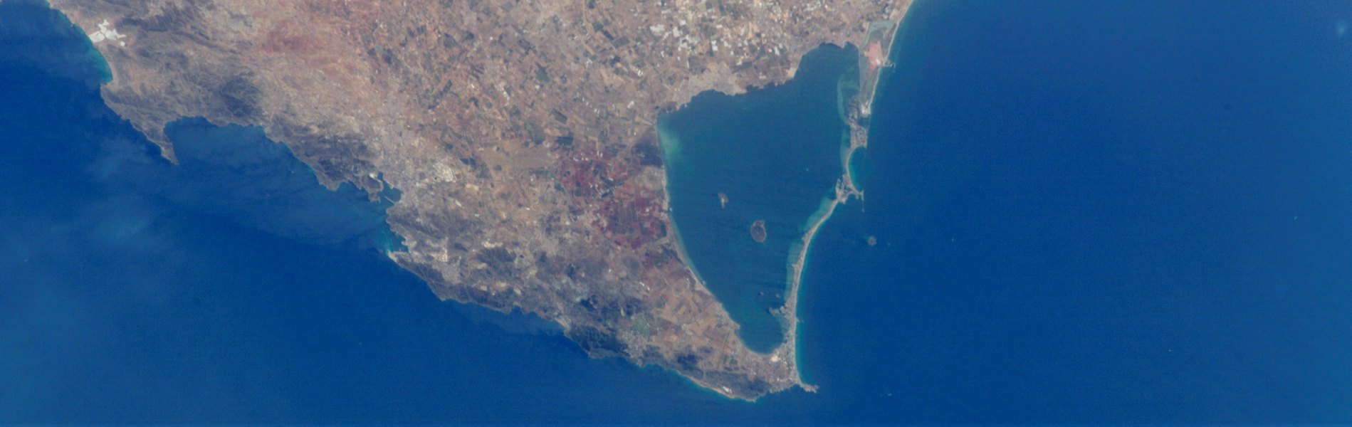
The groundwater discharge of irrigation return flows to the Mar Menor lagoon (Murcia, SE Spain), the largest coastal lagoon in Europe, is among one of the possible causes that would explain the high levels of eutrophication (hypereutrophication) and the several algal blooms accounted in this lagoon ecosystem in the last years. The construction of subsurface drainage system to intersect the groundwater flows in the surroundings of the lagoon is one of the potential solutions proposed to reduce the load of polluted groundwaters that reach the Mar Menor. The objective of this study was to quantify the water balance in the Campo de Cartagena, to simulate the groundwater flow regime in the Quaternary aquifer, and to evaluate the spatial pattern of groundwater discharge to the Mar Menor lagoon for average and extreme hydrological conditions, through the calibration and implementation of a hydrogeological model.
Project description
The groundwater discharge of irrigation return flows to the Mar Menor lagoon (Murcia, SE Spain), the largest coastal lagoon in Europe, is among one of the possible causes that would explain the high levels of eutrophication (hypereutrophication) and the several algal blooms accounted in this lagoon ecosystem in the last years. Previous studies, led and/or participated by FutureWater staff (e.g. Contreras et al., 2014; Jiménez-Martínez et al., 2017) suggest that the contribution of groundwater discharges from the Quaternary aquifer to the Mar Menor would reach values much higher than the ones officially recognized.
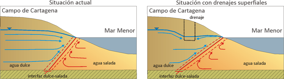
The construction of subsurface drainage system to intersect the groundwater flows in the surroundings of the lagoon is one of the potential solutions proposed to reduce the load of polluted groundwaters that reach the Mar Menor (Figure 1). Once pumped, these waters can be again reused for irrigation after a desalination and denitrification treatment. A large network of subsurface drainage channels are being currently operated by the Arco Sur-Mar Menor Irrigator Association (Arco Sur IA).
The Arco-Sur IA has commissioned FutureWater, in collaboration with Hydrogeomodels, this project in order to evaluate the usefulness of these infrastructures, and to explore the possibilities of extending them to the rest of the Campo de Cartagena region. The use of numerical modelling to simulate the groundwater dynamics in the Quaternary aquifer, and to quantify the spatial patterns of groundwater discharge to the Mar Menor lagoon would help to demonstrate the effectiveness of these type of infrastructures, but also to evaluate the best locations and exploitation regimes possible to reduce the discharges to the Mar Menor without compromising the provision of other ecosystem services (e.g. ecological status of coastal wetlands).
The development and calibration of the hydrogeological model for the Quaternary aquifer of the Campo de Cartagena has been rested on an intense collection of all the data available in the region, and their integration with the most advanced hydrological and hydrogeological simulation techniques. This hydrogeological model is considered a key tool to support decision making, and to evaluate the potential effectiveness of different water management strategies proposed for the region (pumping batteries, drainage networks), but also for assessing the potential impacts that would emerge due to land cover and climate change scenarios.
Objective and Methods
The objective of this study is to quantify the water balance in the Campo de Cartagena, to simulate the groundwater flow regime in the Quaternary aquifer, and to evaluate the spatial pattern of groundwater discharge to the Mar Menor lagoon for average and extreme hydrological conditions, through the calibration and implementation of a hydrogeological model.
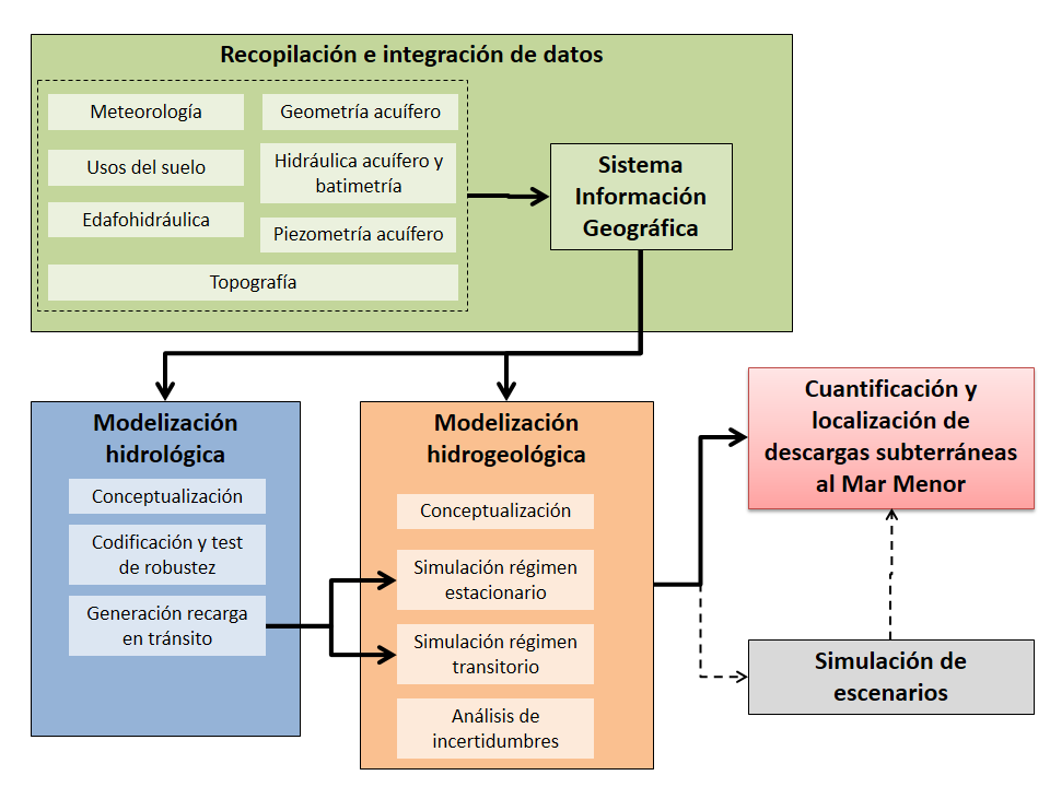
The project has been organized into four tasks (Figure 2): 1) collection and processing of input data, 2) hydrological modeling, 3) hydrogeological modeling, and 4) reporting and and outreach activities.
Related publications
2019 - Science of the Total Environment
 Alcolea, A., S. Contreras, J.E. Hunink, J.L. García-Aróstegui, J. Jiménez-Martínez. 2019. Hydrogeological modelling for the watershed management of the Mar Menor coastal lagoon (Spain). Science of the Total Environment (663) p901-914.X
Hydrogeological modelling for the watershed management of the Mar Menor coastal lagoon (Spain)
Alcolea, A., S. Contreras, J.E. Hunink, J.L. García-Aróstegui, J. Jiménez-Martínez
2017 - FutureWater Report 176
Contreras, S., A. Alcolea, J. Jiménez-Martínez, J.E. Hunink. 2017. Cuantificación de la descarga subterránea al Mar Menor mediante modelización hidrogeológica del acuífero superficial Cuaternario. FutureWater Report 176.XCuantificación de la descarga subterránea al Mar Menor mediante modelización hidrogeológica del acuífero superficial Cuaternario
Contreras, S., A. Alcolea, J. Jiménez-Martínez, J.E. Hunink