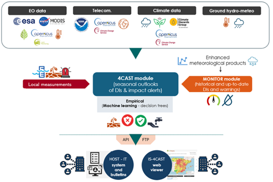
Countries in Asia and the Pacific region are significantly exposed to disaster risks from various hazards and are on the frontline of a climate emergency. Studies suggest that 80% of the globally affected people belong to the Asia-Pacific region, thus emphasizing the critical need for an effective multi-hazard EWS.

EWS, a cost-effective tool for saving lives and reducing economic losses, is particularly crucial for frequent and hazardous weather, water, and climate events. However, despite advancements in the four EWS components, major gaps persist, with implementation lagging and limited coverage in frontline countries, including least developed countries (LDCs) and small island developing states (SIDS). As of 2021, only 50% of countries in Asia and the Pacific reported having multi-hazard early warning systems (MHEWS), emphasizing the need for support.

The culmination of these efforts will be encapsulated in a scoping report, documenting the results of the project, including consultations with key partners and stakeholders during the Regional Workshop on Increasing Investments in Early Warning Systems, to be held in February 2024 in Bangkok, Thailand. The study will offer a comprehensive summary of the EWS scoping, encompassing the policy and institutional landscape, status, initiatives, and investments, as well as residual gaps for regional and national EWS programming in selected DMCs. Additionally, this study will provide guidelines for the implementation and operationalization of the proposed EWS facility, along with initial investment concept notes based on EWS priorities at regional and/or national levels. This holistic approach aims to contribute substantively to the strengthening of EWS capacities, fostering resilience in the face of increasing disaster risks across the region.

Eswatini’s development is at risk by natural drought hazards. Persistent drought is exacerbating the country’s existing challenges of food security and the ability to attain sustainable development. Therefore, FutureWater, Hydrologic, and Emanti Management joined forces to bring together technologies and complementary expertise to implement the GLOW service which includes: short-term and seasonal forecasts of water availability and demand, an alerting service when forecasted water demand is higher than water availability, and water distribution advisories to reduce impact and maximise water security for all water users.

The GLOW service will be piloted in the Maputo River and Mbuluzi River Basins where three-quarters of the population of Eswatini lives, which includes the Hawane dam that supplies water to Mbabane (Capital City of Eswatini) and which is the major water supply source for Maputo, a Delta city (1 million inhabitants) which suffers from water shortages. The main beneficiaries of this project are the Joint River Basin Authority (JBRAS-PB) and the 5 River Basin authorities, AraSul (Mozambique) and the Department of Water and Sanitation (South Africa).

The innovation of GLOW is bringing together proven and award-winning technologies of advanced earth observation, open data, high-performance computing, data-driven modelling, data science, machine learning, operations research, and stakeholder interaction. These technologies require minimum ground truth information, which makes them very scalable and applicable in poorly monitored environments throughout the world. The coherent combination of the technologies into one decision support service ensures the optimum division of water, basically distributing every drop of water to meet the demands of all interests present in large river catchments.

Water and food security are at risk in many places in the world: now and most likely even more in the future, having large economic and humanitarian consequences. Risk managers and decision-makers, such as water management authorities and humanitarian-aid agencies/NGOs, can prevent harmful consequences more efficiently if information is available on-time on (1) the impact on the system, economy or society, and also (2) the probabilities for a failure in the system. EO information has proven to be extremely useful for (1). For looking into the future, considering the uncertainties, novel machine learning techniques are becoming available.

The proposed development is incorporated into an existing solution for providing Drought and Early Warning Systems (DEWS), called InfoSequia. InfoSequia is a modular and flexible toolbox for the operational assessment of drought patterns and drought severity. Currently, the InfoSequia toolbox provides a comprehensive picture of current drought status, based mainly on EO data, through its InfoSequia-MONITOR module. The proposed additional module, called InfoSequia-4CAST, is a major extension of current InfoSequia capabilities, responding to needs that have been assessed in several previous experiences.

InfoSequia-4CAST provides the user with timely, future outlooks of drought impacts on crop yield and water supply. These forecasts are provided on the seasonal scale, i.e. 3-6 months ahead. Seasonal outlooks are computed by a novel state-of-the-art Machine Learning technique. This technique has already been tested for applications related to crop production forecasting and agricultural drought risk financing. The FFTrees algorithm uses predictor datasets (in this case, a range of climate variability indices alongside other climatic and vegetative indices) to generate FFTs predicting a binary outcome – crop yields or water supply-demand balance above or below a given threshold (failure: yes/no).

The activity includes intensive collaboration with stakeholders in Spain, Colombia and Mozambique, in order to establish user requirements, inform system design, and achieve pilot implementation of the system in the second project year. Generic machine learning procedures for training the required FFTs will be developed, and configured for these pilot areas. An intuitive user interface is developed for disseminating the output information to the end users. In addition to development of the forecasting functionality, InfoSequia-MONITOR will be upgraded by integrating state-of-the art ESA satellite data and creating multi-sensor blended drought indices.

The Ministry of Water and Environment in Bolivia has asked the Dutch Government for support in relation to the drought issues they face. Last week, a team consisting of team leader Otto de Keizer (Deltares) and Johannes Hunink (FutureWater) left for Bolivia. As a result of El Niño, the country is struggling with a long and extreme drought period, which in November 2016 led to an acute water shortage in the capital La Paz and other areas of the country.

The Dutch government together with the Dutch water sector founded the Dutch Risk Reduction Team (DRR-Team). With the DRR instrument the Netherlands is able to cover the entire disaster management cycle from mitigation, preparedness and response to recovery.

To address the drought problem in Bolivia, the DRR-Team has been asked to provide recommendations on drought early warning and drought information systems, both on technical aspects as well as on institutional issues. The team has held talks with the Ministry of Environment and Water, the La Paz and Potosí drinking water companies, and the municipality of La Paz. In addition, they also consulted with SENAMHI: the National Hydrometeorological Institute. The DRR-Team drew up with a team of experts of the World Bank that supports Bolivia with several necessary investments to reduce vulnerability to drought.

Groundwater is one of the most important freshwater resources for mankind and for ecosystems. Assessing groundwater resources and developing sustainable water management plans based on this resource is a major field of activity for science, water authorities and consultancies worldwide. Due to its fundamental role in the Earth’s water and energy cycles, groundwater has been declared as an Essential Climate Variable (ECV) by GCOS, the Global Climate Observing System. The Copernicus Services, however, do not yet deliver data on this fundamental resource, nor is there any other data source worldwide that operationally provides information on changing groundwater resources in a consistent way, observation-based, and with global coverage. This gap will be closed by G3P, the Global Gravity-based Groundwater Product.

The G3P consortium combines key expertise from science and industry across Europe that optimally allows to (1) capitalize from the unique capability of GRACE and GRACE-FO satellite gravimetry as the only remote sensing technology to monitor subsurface mass variations and thus groundwater storage change for large areas, (2) incorporate and advance a wealth of products on storage compartments of the water cycle that are part of the Copernicus portfolio, and (3) disseminate unprecedented information on changing groundwater storage to the global and European user community, including European-scale use cases of political relevance as a demonstrator for industry potential in the water sector. In combination, the G3P development is a novel and cross-cutting extension of the Copernicus portfolio towards essential information on the changing state of water resources at the European and global scale. G3P is timely given the recent launch of GRACE-FO that opens up the chance for gravity-based time series with sufficient length to monitor climate-induced and human-induced processes over more than 20 years, and to boost European space technology on board these satellites.

In this project, FutureWater is in charge of a case which aims to prototype and calibrate a Groundwater Drought Index based on the G3P product, and to integrate it into InfoSequia, the FutureWater’s in-house Drought Early Warning System. The new InfoSequia component will be tested for inherent reliability and flexibility at the basin level in a total area of about 145 000 km2 in Southern Spain which largely relies on groundwater resources. This pilot region comprises three large basins (Segura, Guadalquivir and Guadiana) with many aquifers and groundwater bodies where very severe dynamics of overexploitation and mining have been identified and declared. Unsustainable groundwater development threats the water security in the region, but also the ecological status and preservation of unique and highly protected ecosystems in Europe (e.g., Doñana National Park, Daimiel National Park, Mar Menor coastal lagoon).

To visit the official G3P website, please click on this link: https://www.g3p.eu

Twiga’ is the Swahili word for ‘giraffe’, a keen observer of the African landscape. TWIGA aims to provide actionable geo-information on weather, water, and climate in Africa through innovative combinations of new in situ sensors and satellite-based geo-data. With the foreseen new services, TWIGA expects to reach twelve million people within the four years of the project, based on sustainable business models.

Africa needs reliable geo-information to develop its human and natural resources. Sixty percent of all uncultivated arable land lies in Africa. At the same time Africa is extremely vulnerable to climate change. Unfortunately, the in situ observation networks for weather, water, and climate have been declining since the 1970s. As a result, rainfall predictions in Africa for tomorrow have the same accuracy as predictions in Europe, ten days ahead. To realize the tremendous potential of Africa while safeguarding the population against impacts of climate change, Earth observation must be enhanced and actionable geoinformation services must be developed for policy makers, businesses, and citizens. New in situ observations need to be developed that leverage the satellite information provided through GEOSS and Copernicus (Open data/information systems).

TWIGA covers the complete value chain, from sensor observation, to GEOSS data and actionable geoinformation services for the African market. The logic followed throughout is that in situ observation, combined with satellite observations and mathematical models, will result in products consisting of maps and time series of basic variables, such as atmospheric water vapour, soil moisture, or crop stage. These products are either produced within TWIGA, or are already available with the GEOSS and Copernicus information systems. These products of basic variables are then combined and processed to derive actionable geo-information, such as flash flood warnings, sowing dates, or infra-structural maintenance scheduling.

The TWIGA consortium comprises seven research organisations, nine SMEs and two government organisations. In addition it uses a network of 500 ground weather stations in Africa, providing ready-to-use technical infrastructure.

FutureWater’s main role in TWIGA is centered around the use of flying sensors to map crop conditons, flood extent, and energy fluxes, complementing and improving data from in situ sensors and satellites. Furthermore, FutureWater is involved in innovative app development.

To support a sustainable and equitable management of increasingly pressurised water resources, water authorities need to have access to up-to-date information on the availability and use of those resources. However, such information is often scarce, or may at best be only available as static data in reports. This may lead to sub-optimal decisions, particularly during critical situations such as droughts, may diminish water security, slow down economic and social development, and even lead to disputes and conflicts on water allocation.

HERMANA aims to foster the development of an integrated water management decision support system (DSS) that supports daily, tactical and strategic decision-making related to water resources in Colombia, and specifically in the Cauca Valley Basin. The HERMANA tool will be a comprehensive system able to provide valuable, relevant, and reliable groundwater and surface water data, and information to high level decision makers and specific users, to an appropriate level of detail and at the time that it is required. HERMANA, which is based on the example of such integrated real-time decision support systems recently developed at selected Water Boards in the Netherlands, it will be executed by a solid team of experts in water resources, DSS, operational, tactical, and strategic water management and governance, that can work together to support water managers and governments around the world.

Objectives

The main objective of this project is to develop an integrated water management decision support system, HERMANA, which will enable CVC to make more informed decisions related to water management in the Cauca Valley. This project will contribute primarily to better informed and more transparent decision-making in managing water resources, in particular through the incorporation of the dynamic nature of groundwater resources and use, considering these as an integral part of the water resources in a river basin. This will contribute to a more balanced management of surface and groundwater resources and lead to improved water security. The goal is that this system will foster IWRM, as well as improving water use and efficiency.

Concretely, the goals of this project are to:

  • Provide CVC with an instrument to communicate with stakeholders;
  • Advance in the process of involving stakeholders in water-related decision-making;
  • Progress in the co-design of integrated water resources management tools and evaluate the lessons learned that can also be applied in the Netherlands;
  • Strengthen the cooperation between the consortium partners for future collaboration;
  • Develop a product to support IWRM that combines the complementary expertise of the Dutch water sector, including businesses (HydroLogic, FutureWater), a knowledge institute (Deltares), and public authorities (DWA), which can be replicated elsewhere; and
  • Develop a business case to show the viability of this system so that it can be implemented in other river basins in Colombia and elsewhere around the world.

Role of FutureWater

In this project, FutureWater has the mission to bridge the gap between scientific knowledge and practical applications for drought monitoring and sustainable water management. FutureWater will configurate and implement the InfoSequia drought monitoring system (www.infosequia.es) as part of HERMANA, and will contribute to the definition of scenarios and strategies for water management in the Cauca Valley region, and to the overall evaluation of existing tools and models available in HERMANA.

Imprex-tagline-cmyk
IMPREX exploits the idea that understanding present-day risks is an effective starting point for adapting to unprecedented future events. Taking into account potential climate trajectories and a collection of experiences in various vulnerable water-related sectors, IMPREX will put current management decisions and practices in the context of an emergent future. In addition, the way in which current operational forecasts of potentially high-impact events at various time scales are utilized can still be improved, not only by enhancing the forecasting skill, but also by customizing the information to the stakeholders’ needs, practice and decision context.

The core elements of IMPREX consist of three interconnected science- and user-oriented actions: (a) an improvement in the forecasting and foresighting tools and climatologies of hydrological extremes, (b) application of these developments in the daily practice of stakeholders across different sectors and regions, and (c) dissemination of the experience gained from the sectoral impact  analyses to a wider audience by means of user-friendly assessment summaries of impact and adaptation strategies, periodic risk outlooks, and bulletins for public communication.

imprex pict
IMPREX will improve predictability at short-medium and seasonal time scales (upper two block arrows), and will develop new concepts to allow translation of the experience with present day events into the future (bottom arrow).

IMPREX will deliver:

  • A measurable improvement in forecast skill of meteorological and hydrological extremes in Europe and their impacts
  • A demonstration of the value of the information on hydrological impacts to relevant stakeholders through a set of representative case studies.
  • Novel risk assessment concepts that respond to limitations of current methods and practices
  • A pan-European assessment of existing and adapted risk management and adaptation strategies
  • A periodic outlook of expected hydrological and water resources (trans-)sectoral risks in Europe linking outputs to existing systems such as the European Flood Awareness System and the European Drought Observatory.

FutureWater leads the coordination of the “Agriculture and Drought” sectoral Work Package. This WP specifically aims to study and evaluate the use of IMPREX weather forecasts and predictions, climate variability, and drought indicators to assess agricultural drought risk and impacts over four case studies and at the pan-European level. An special emphasis will be placed in:

  • improving our understanding on the relationships between climate variability, hydrological drought indicators, and agricultural production and losses and, finding these relations in four Mediterranean case basins
  • developing downscaling methods in order to provide agricultural drought indicators useful at the basin level and according to the specific needs of the case study basins and their currently operational drought management systems.
  • designing appropriate tools and communication/dissemination channels for generating effective and transparent drought alerts to water managers and stakeholders in the agricultural sector.
  • quantifying the impact of changing rainfall, evapotranspiration and atmospheric recycling dynamics on water fluxes, flows, stocks, consumption and the provision of services to agriculture for the major basins of Europe using a generic analytical framework (WA+).

Links

Videos