On June 25, we celebrated the successful closure of the RoSPro project with a national workshop held in Nepal. The event brought together key stakeholders to reflect on the project’s positive outcomes, including improved spring water access, road resilience, and community engagement in water management.

A key highlight of the project was the Decision Support System (DSS) developed by FutureWater. This system integrated hydrological (as an outcome of the SPHY hydrological model), geospatial, and socioeconomic data into a user-friendly platform, enabling data-driven decisions for sustainable water management. Moreover, the system provides a simple Cost&Benefit Calculator to assist stakeholders in evaluating the potential of proposed management measures for mountain springs.

The workshop underscored the potential for scaling up the approach in other regions, using the DSS to guide future spring protection and water resource management efforts. We look forward to continue this work in the future!

An open access version of the DSS is available here

Cover picture of the DSS

The approach of FutureWater and Galayr is designed to be both scientifically rigorous and contextually grounded, ensuring that the developed drought model is locally relevant, sustainable, and fully integrated into existing national systems such as those of SODMA and NADFOR. The model will merge top-down (data-driven, machine learning-enabled) and bottom-up (stakeholder-informed) approaches, combining satellite data, climate indices, and indigenous knowledge to co-develop impact-based forecasts and consensus-based triggers for anticipatory action.

For the development of the drought forecasting model and the knowledge transfer we will focus on the following pillars:

  • A phased work plan that spans institutional capacity assessments, model development, validation, stakeholder consultations, and hands-on capacity building.
  • Application of state-of-the-art forecasting models ranging from ARIMA and regression to more advanced machine learning techniques, while maintaining focus on usability and institutional adoption.
  • A strong emphasis on knowledge transfer, including training programs and the establishment of a collaborative knowledge-sharing platform using the FutureWater Academy platform
  • A robust risk management plan, including mitigation strategies for data scarcity, stakeholder disengagement, and institutional turnover.


The BUCRA (Building Unity for Climate Resilient Agriculture) project focuses on enhancing agricultural resilience in Qahbunah, a farming community in Egypt’s Nile Delta. Facing challenges like water scarcity, climate change, and land fragmentation, local farmers require innovative approaches to sustain their livelihoods.

At the heart of BUCRA are two cutting-edge tools developed by FutureWater: Croptimal and SOSIA, which combine advanced technology with local insights to transform traditional farming practices.

Croptimal is a climate suitability analysis tool that leverages climate projections, geospatial data, and agricultural insights to assess the suitability of various crops under current and future climate scenarios. By identifying areas and crops that are most resilient to climate stressors like heat, salinity, and water scarcity, Croptimal empowers farmers with data-driven recommendations to optimize their crop choices and planting strategies. This tool provides highly detailed maps and actionable advice, enabling farmers to adapt their practices to the challenges of climate change while enhancing productivity.

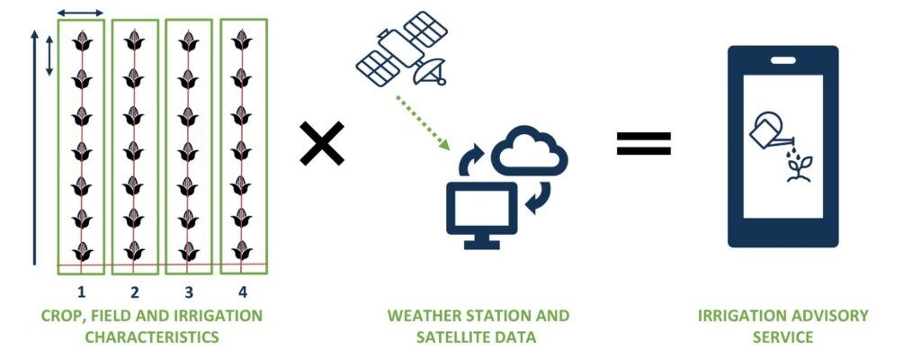
SOSIA (Satellite-based Open-source Irrigation Advisory) is an irrigation management tool designed to improve water use efficiency. It uses open-source satellite data, real-time weather information, and local soil conditions to provide precise daily irrigation advice. Farmers receive recommendations on how long to irrigate their crops each day via WhatsApp, making the service both accessible and cost-effective. This innovative approach not only reduces water usage but also improves crop yields and energy efficiency, addressing the increasing pressures on water resources in the Nile Delta.

In addition to these tools, BUCRA includes demonstration plots showcasing climate-smart techniques such as efficient irrigation, soil management, and crop rotation. Farmers will also participate in a blended learning program that combines field-based training with easy-to-use digital applications to improve their technical skills and knowledge.
BUCRA emphasizes empowering youth and women in agriculture, strengthening market linkages, and promoting sustainable land-use practices. By aligning Dutch expertise with local needs, the project aims to boost productivity, stabilize incomes, and build a sustainable agricultural future in Qahbunah.

The long-term vision is to inspire broader adoption of these tools and practices, ensuring food and water security in the region while addressing the challenges posed by climate change.

Graphical User Interfaces are available for QGIS but only for SPHY v2.0 at the moment. This project will upgrade these plugins in order to make them compatible with the latest versions of SPHY (v3.0 and v3.1), QGIS and Python available. The updated plugins will also incorporate the additional functionalities to process state of the art new data sources as inputs.

As SPHY is used by FutureWater in several capacity building programs, our aim is to make the access to the data and the model as easy and intuitive as possible. With updated QGIS Plugins, no programming skills will be required to run the model, so a broader audience can use SPHY for their own purposes.

More information can be found at the SPHY website.

Most recent research has focused on identifying historical megadroughts based on paleo-records and understanding their climatic causes, or on the study of “modern” events and their impacts, generally in lowland and plain regions. However, high-mountain regions and snow-dependent catchments have been little studied, and little is known about the impact of megadroughts on the state and dynamics of the cryosphere in mountain water towers.

In general, catchments dependent on high mountain systems have an intrinsic capacity to buffer the lack of precipitation and excess evapotranspiration that depends on the water reserves stored in the cryosphere (snow, glaciers and permafrost). It is presumed that the this buffer capacity is limited until a tipping point is reached from which the impacts of water shortages and temperature extremes may be amplified and jeopardize the functioning of ecosystems and water resource systems.

Megawat has a double objective: 1) to address the knowledge gaps around the hydro-climatic causes of extreme droughts and their impact on the water balance of Europe’s mountain water towers, with special emphasis on the concurrence of compound events and cascading and multi-scale effects and 2) to develop and propose new adaptation strategies to cope with the duration, extent and severity of future megadroughts and their potential impacts on environmental and socio-economic assets.

For its implementation, MegaWat focuses on Europe’s high mountain regions and their dependent-catchments. MegaWat aims to develop three products:

  • Product 1. A methodological framework for the identification and characterization of historical megadroughts during the instrumental period, and the assessment of the role of the cryosphere in supporting the landscape development of downstream areas, or in buffering climate change impacts. Product 1 relies on a combination of climate regionalization, surface energy balance modelling, hydrological simulation, and water evaluation and allocation analysis at the catchment level (figure below).
  • Product 2. A high-resolution, open-access regionalized climate database.
  • Product 3. A list of potential adaptation strategies useful for the prevention and mitigation of drought impacts, and the enhancement of the water security and resilience of high mountain regions and dependent catchments. These scenarios will be agreed with regional and local actors and stakeholders, and their effectiveness will be evaluated under extreme drought scenarios in three pilot regions in Europe. These pilot regions will be previously selected following criteria of representativeness, strategic importance and vulnerability to droughts.


Schematic representation of a high mountain basin, including the main components, processes and impacts related to droughts.

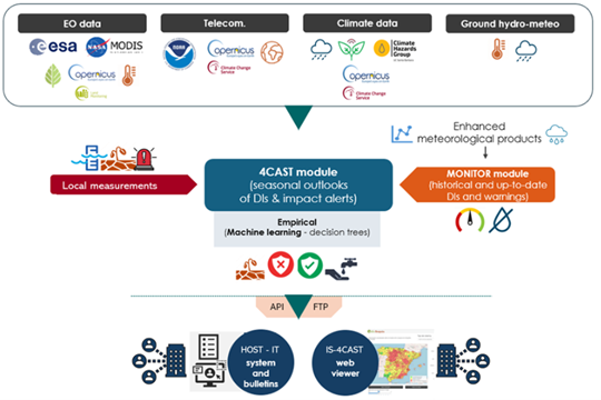
FutureWater plays an important role in MegaWat by coordinating the Work Package which aims to develop and test simulation tools that help to adapt to megadroughts and support the decision making process. Two specific objectives are pursued in this Work Package: a) the development of a methodological prototype for quantifying impacts and identifying tipping points for water security in snow-dependent downstream catchments, and b) the generation and the integration of snow drought indicators in the FutureWater’s Drought Early Warning System called InfoSequia (figure below).

Workflow of the InfoSequia Early Warning System developed by FutureWater and adapted for the detection of tipping-points of water scarcity in snow-dependent catchments. More information about InfoSequia.

A one-pager can be downloaded here.

Acknowledgements

This project has received funding from the Water4All programme with co-funding from CDTI (Spanish Office for Science and Technology) and the EU’s Horizon Europe Framework Programme for Research and Innovation.

This week marked a significant milestone for the MAGDA Project as the Mid-term Review Meeting was held in the city of Beaune, France. Over the course of two days, the consortium gathered to conduct a comprehensive assessment of the progress achieved during the first half of the project. Reflecting on past achievements, the gathering also served as an opportunity to outline the roadmap for the project’s successful completion.

A highlight of the event was a field visit to one of the project’s pilot areas, offering firsthand insights into the practical implementation of MAGDA equipment. The field visit provided a unique opportunity to witness the innovative solutions in action, including the cutting-edge metodrone developed by MeteoMatics and state-of-the-art meteorological stations provided by CAP2020.

As the MAGDA Project enters its second phase, the momentum generated in Beaune sets a promising roadmap for continued success.

The MAGDA project aims at providing an integrated – but modular – system to provide severe weather forecasts and irrigation advisories enhanced by means of various satellite-borne, drone-borne and ground-based weather-observing technologies. The main applications will be in providing both warnings about severe weather that could affect crops and irrigation advisories based on enhanced rain forecasts. These warnings and advisories will be channelled through a Farm Management System to ensure the capability to effectively reach farmers and agricultural operators.

Consortium at the meteodrone location
Meteorological station at the demo site
Meteodrone before performing demo flight


This week, the second part of the Water Accounting Training for the Agriculture, Climate and Water Sector Organizations in Pakistan has been successfully completed at the Food and Agriculture Organization of the United Nations (FAO) office in Islamabad, Pakistan.

As an agrarian economy that heavily depends on water, it is crucial for Pakistan to adopt a more integrated water management approach and formulate data-driven strategies to avert from the deepening water crisis.

This training has been designed by FutureWater and FAO as part of the Green Climate Fund funded project titled: ‘Transforming the Indus Basin with Climate Resilient Agriculture and Water Management’. Component 1 of this project focuses on enhancing information services for climate change adaptation in the water and agriculture sectors.

This second part of the training is comprised in seven modules and the aim is to enable stakeholders to develop water accounts at different scales. Given the growing issues of water scarcity, climate change impacts and unmet irrigation demands, this water accounting system can aid decision-makers to design evidence-based policies and achieve sustainable water resources management.

In this in-person training of one week, participants further extended their knowledge on how to compute inflows and outflows of a system at using remote sensing and assessing global datasets.

More information about the project can be found here.

Group presentation
Group picture
Theoretic lesson

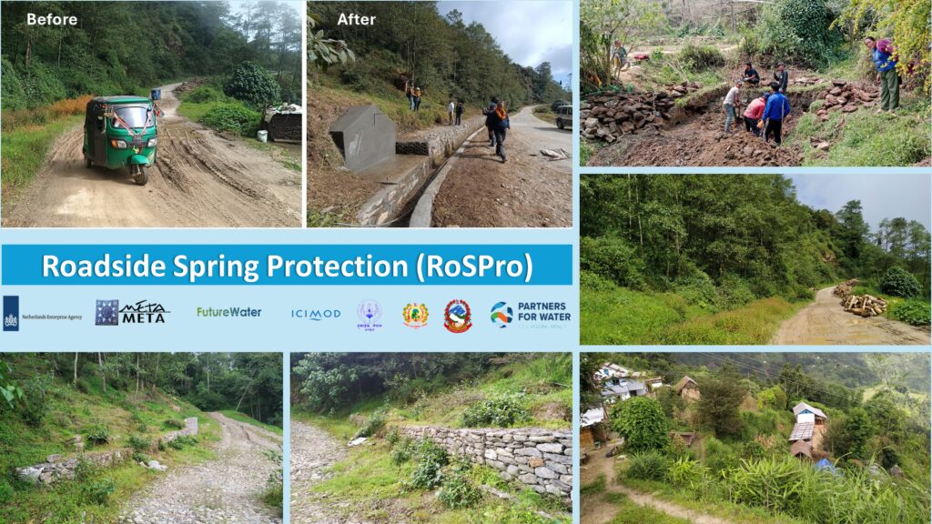
The alarming decline of springs has been attributed to the rapid expansion of road networks, alongside changes in land cover and climate. Road development in these areas exposes springs to disturbances or alters their natural outflow, while rock cutting disrupts the location of spring orifices. This problem has largely gone unnoticed, posing a significant threat to the local communities and their water resources.

The overarching goal of the project is to reimagine roads as instruments for landscape improvement rather than adversaries, harnessing road development to contribute positively to local water resources. By integrating techniques and tools (Digital twins and DSS toolkit), the project aims to ensure safe and reliable water supplies for people in mountain areas while safeguarding the quality of road infrastructure and maintaining connectivity. The Dhankuta municipality and the Department of Local Infrastructure (DoLI), which regulates infrastructure development activities in Nepal, will be the primary beneficiaries of this project.

The expected results of the RoSPro project include:

  1. Successful implementation of roadside spring protection through pilot interventions in Dhankuta municipality and promote “Nature-based solutions” and “Green Roads for Water (GR4W)” approaches.
  2. Evidence generation on the impact of the pilot intervention through cost-benefit analysis.
  3. Assessment of the potential impact of upscaling roadside spring protection through the development of a digital twin and decision support toolkit.
  4. Capacity building for Dhankuta municipality and DoLI regarding roadside spring protection approaches, technologies, impact, and upscaling.

RoSPro will lead to improved water security for consumptive and productive uses, directly benefiting up to 500 households in the region. Following the pilot phase, the project aims to expand its services to established clients and partner networks in Asia and Africa. The demand for similar services is high in many high mountain countries, and RoSPro aims to generate a framework to upscale this at national and regional scales.

Thus, the RoSPro is a vital initiative that seeks to address the critical issue of dwindling springs in the Himalayas. By transforming road development into a contributor to local water resources, RoSPro will improve water safety and security, benefiting both the communities and the environment in these challenging mountainous regions.

On May 22-23, FutureWater attended the Preliminary Design Review Meeting (PDR) for the MAGDA project in Bucharest, Romania.

The meeting was hosted by the National Meteorological Administration, and it was a great opportunity for project partners to meet in person and present the latest achievements. The major outputs from the first six project months were the following:

  • Selection of the three major MAGDA demo sites in France, Italy and Romania.
  • Analysis of MAGDA user requirements (surveys for the agricultural and water sectors are still open for participation!)
  • Detailed MAGDA system design: Summary of the technical data requirements of GNSS stations, IoT sensors, Meteodrones, remote sensing, weather forecast and hydrology modelling with SPHY.

The next months will now be used to install the equipment at the demo sites and start with the first modelling and site measurements, as well as the evaluation of historical data for calibration.

FutureWater is leading the irrigation advisory service of MAGDA, making use of hydrological modelling using SPHY (Spatial Processes in Hydrology). The output expected consists of an operational irrigation service to provide advice on when and how much to irrigate at certain moments during the cropping season, using as input data improved weather forecasts.

More information about the project can be found here and visiting the MAGDA Project website.

FutureWater presentation on MAGDA System Architecture
Preliminary Design Review Meeting
MAGDA Partners at MeteoRomania


Last week, the first part of the Water Accounting Training for the Agriculture, Climate and Water Sector Organizations in Pakistan was successfully completed at the Food and Agriculture Organization of the United Nations (FAO) office in Islamabad, Pakistan.

This training has been designed by FutureWater and FAO as part of the Green Climate Fund funded project titled: ‘Transforming the Indus Basin with Climate Resilient Agriculture and Water Management’. Component 1 of this project focuses on enhancing information services for climate change adaptation in the water and agriculture sectors.

FutureWater conducted a capacity needs assesment in order to design a tailor made training that facilitates the development of water accounts at different scales (from basin to water course level) for key stakeholders in Pakistan. In total, approximately 30 participants from federal and provincial government departments (Punjab and Sindh) as well as academia actively participated in the training program.

The training consisted of the following three modules:

  1. Introduction to the components of Water Accounting
  2. Understanding and quantifying water pathways within a domain (using FutureWater’s in-house tools: REWAS and Follow the Water)
  3. Understanding and quantifying water inflows and outflows (using Google Earth Engine for accessing and processing remotely sensed datasets).
In person sessions at FAO office in Islamabad
Theory presentation
Group work discussion