FutureWater took part in a technical modeling workshop hosted by the Asian Development Bank (ADB) in Manila, bringing its expertise in glacio-hydrological modeling and climate adaptation investment planning to discussions on how to build the analytical backbone for resilient river basins across Asia. The workshop forms part of the inception phase of the 3POLE4FOOD project, FutureWater’s contribution to ADB’s Resilient River Basin Initiative (RRBI) in the Hindu Kush–Himalaya (HKH) region.

The day-long session gathered around ADB staff and external experts to exchange experiences on integrated modeling and to chart the conceptual design of the computational framework that will underpin RRBI’s work. The central question: what kind of analytical tools should the initiative develop so that ADB’s developing member countries (DMCs) can identify, prioritize, and finance climate adaptation investments in their river basins?

FutureWater’s role: from glaciers to investment decisions

Working alongside Wageningen University & Research (WUR), FutureWater is developing and applying the models that describe mountain hydrology and food production across the HKH. The team’s approach couples SPHY, FutureWater’s spatial processes in hydrology model, with the LPJmL crop-hydrology model, driven by climate forcing derived from climate model ensembles. Together these tools capture the chain from snow and glacier melt in the high mountains through to downstream water availability and agricultural production — the foundation any climate adaptation investment plan in the region depends on.

A key outcome of the workshop — shaped in part by a contribution from FutureWater’s Johannes Hunink — was consensus on a three-level modeling architecture that ensures consistency from regional screening down to individual interventions:

  • Regional level — for awareness raising and identifying hotspots, where the SPHY-LPJmL models excel as the dynamic baseline;
  • River basin level — for water allocation and investment portfolio development, using network-based models such as WEAP and RIBASIM that DMCs already know and trust;
  • Intervention level — for feasibility studies and detailed engineering design which rely on detailed physically-based methods and models like AquaCrop, SWAT, HEC-RAS, etc.

Each level builds on the one above, with outputs from the regional models forcing or informing in some way the inputs of more detailed tools. Participants stressed prioritizing credibility and local buy-in over model detail, favoring a “planning toolkit” approach that integrates trusted local tools rather than building monolithic, hard-to-maintain decision-support systems. There was broad recognition that river basin simulation models, combined with benefit-cost analysis, offer a more practical route to bankable projects than fully integrated hydro-economic models.

Next steps

The workshop conclusions will guide the development of terms of reference for the next phase of RRBI’s technical work, including a review of modeling capacities and tools already available in the DMCs, and the launch of a Community of Practice. For FutureWater, the workshop marks an important early milestone in the 3POLE4FOOD inception phase, anchoring its glacio-hydrological modeling and adaptation-investment expertise within ADB’s wider effort to make Asia’s river basins more resilient to climate change.
 

Home to the world’s largest semi-natural walnut-fruit forest, the Arslanbob region in Jalal-Abad province has lost roughly half of its forest cover between 1990 and 2018, with forest extent declining from over 100,000 hectares to around 45,000 hectares. Unsustainable pasture use, overgrazing, forest encroachment, and weak enforcement of land-use regulations have constrained natural regeneration. At the same time, climate change is intensifying ecological stress: temperatures in the Kyrgyz Republic have risen by 1.3°C over the past four decades and are projected to climb further, bringing late frosts that affect walnut yields, drying springs, declining snowpack and groundwater recharge, more frequent pest outbreaks and wildfires, and heightened landslide and erosion hazards. Beyond their economic value, these forests regulate water flows to the downstream Ferghana valley, stabilize slopes, and reduce the risk of floods, landslides, and mudflows.

With support from ADB, the CARE project promotes Nature-based Solutions including reforestation, sustainable pasture management, adaptive agroforestry, and integrated forest-pasture governance, supported by digital monitoring and community engagement. To ensure these interventions are designed to withstand future climate conditions, FutureWater conducted a detailed climate risk and adaptation assessment which included:

  1. An analysis of historic climate and CMIP6-based future climate projections for Jalal-Abad province, including trends in temperature, precipitation, seasonality, and climate extremes under SSP2-4.5 and SSP5-8.5
  2. A climate risk assessment combining hazard, exposure, and vulnerability information to evaluate the project’s risk from floods, droughts, heatwaves, wildfires, landslides, and mudflows
  3. A set of targeted adaptation options, such as diversification of species composition, climate-informed regeneration zoning, soil organic carbon enhancement, water harvesting, and dynamic grazing plans
  4. An estimate of the greenhouse gas mitigation potential of forest regeneration and improved pastureland management.

The objective is to strengthen IoE’s in-house modeling capability for climate risks and geohazards in Abkhazia — particularly mudflow and landslide susceptibility — by designing and delivering targeted online training and providing follow-on coaching, so the institute can independently apply these modeling approaches in its flood risk assessments and mitigation planning.

Armenia is a landlocked country in the Southern Caucasus with a dry climate, where the highest precipitation falls in the mountains. Its surface and groundwater resources — around 9 bcm of usable water annually — support hydropower (over 30% of the national energy mix), irrigation (80% of crops), and drinking water supply, with reservoir storage playing a central role in balancing demand across seasons. Yet warming is shifting snowmelt earlier in the year, and river flows are projected to decline by roughly 14% by 2040 and up to 39% by the end of the century. This places Armenia’s 87 existing dams, and a pipeline of planned reservoirs, under increasing pressure.

For the Asian Development Bank (ADB), FutureWater conducts a climate risk assessment of water resources availability in Armenia’s six primary river basins, with a focus on existing and planned reservoirs. The assessment combines the SPHY hydrological model with downscaled climate projections from ERA5 and NASA-NEX. The specific activities include:

  • Collecting DEM, soil, land use, and historical and future climate data for the six primary river basins.
  • Assessing water resources availability and inter-annual and seasonal variability using a hydrological model, including inflows to a selected set of key reservoirs.
  • Assessing climate change impacts on water resources, including changes in snowmelt contributions.
  • Calculating impact indicators for the basins and reservoirs — potential refill frequency, and high- and low-flow indicators.
  • Prioritising existing and planned reservoirs by climate risk and adaptation potential, to support ADB investment decisions and Armenia’s national water resources planning.
  • Identifying preliminary adaptation solutions in consultation with government counterparts and development partners.

A central focus is seasonality. Reservoir operation depends not only on annual water volumes but on when water arrives, and the shift to earlier snowmelt and reduced summer baseflow has direct consequences for reservoir filling schedules, irrigation timing, and the design of new storage infrastructure. The findings — including a prioritised shortlist of reservoirs for adaptation investment — will inform ADB’s investment pipeline under the Glacier to Farms programme and Armenia’s long-term water resources planning. The work is delivered in close consultation with Armenia’s Ministry of Environment, Ministry of Territorial Administration and Infrastructure, and Ministry of Economy.

The project delivers a complete, decision-ready climate-hazard reference for each of Georgia’s ten provinces (the nine mkhare plus the Adjara Autonomous Republic). Specifically, it (i) compiles a consistent climate-trend signal across eight indicators per province under the CMIP6 high-emissions scenario, (ii) translates gridded hazard datasets and global hazard rating databases into a comparable Low–Severe severity scale for six hazards per province across three time horizons (current, 2050, 2090), and (iii) packages these into A4 poster-style profiles ready for inclusion in ADB programme reporting and provincial design workshops.

FutureWater built a reproducible pipeline that brings together three layers of evidence: long-term climate projections, gridded hazard data, and current-day hazard ratings supplemented by Georgia-tuned sea-level rise for the coastal provinces. A hybrid severity strategy selects the most defensible source per hazard, using gridded data where available and expert-calibrated uplift rules on future climate indicators where not. The output for each province is a single one-page profile combining maps, indicator trend charts, and hazard matrices across three time horizons.

With these profiles, ADB and the Government of Georgia’s water-sector counterparts will be able to prioritize settlement-level climate adaptation measures across all ten provinces against a shared, citable evidence base, defend infrastructure-design choices against a transparent severity rating, and re-run the pipeline as updated climate projections and improved gridded hazard layers become available. The same approach can be reused as a template for settlement-level climate screening elsewhere in ADB’s regional water portfolio.

MountAInWater will deliver the first-ever comprehensive global reanalysis of mountain water resources, combining high-resolution physically-based modelling with artificial intelligence. The project starts with detailed fieldwork and modelling at four “supersites” in the Canadian Rockies, the Andes, the Pamir and the Himalaya. These simulations will train AI models that allow the approach to scale globally, covering all major mountain ranges at resolutions as fine as one kilometer. The project addresses non-linearities and tipping points in glaciers, snow and permafrost that have rarely been considered to date. Once the global reanalysis is complete, the team will zoom in on regional hotspots, areas facing significant changes in water availability, to assess societal and ecological impacts and collaborate with local stakeholders on adaptation strategies.

Together with Wageningen University and Hydrominds, FutureWater will focus on identifying water scarcity hotspots and simulating water resources allocation in downstream regions. This involves assessing where and when mountain water is used for irrigation, drinking water and hydropower, and how climate-driven changes in mountain hydrology will affect water security for downstream communities.

The project brings together partners from six countries: ISTA (Austria, lead), ETH Zurich (Switzerland), Technical University of Munich (Germany), University of Lausanne (Switzerland), Utrecht University (Netherlands), University of Saskatchewan (Canada), Wageningen University (Netherlands), FutureWater (Netherlands) and Climate Adaptation Services (Netherlands).

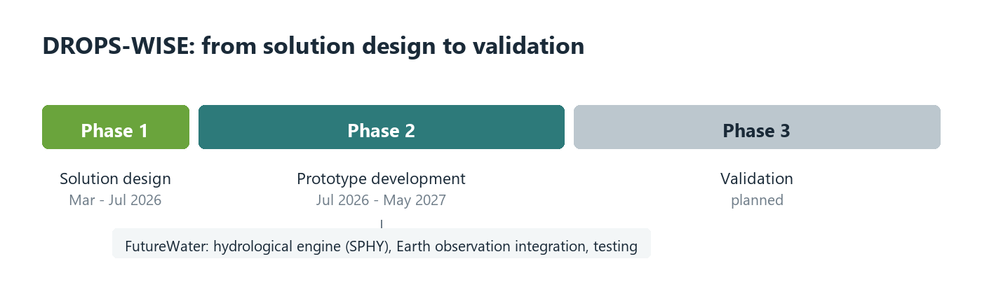
Through a user-friendly web interface and interoperable data services, DROPS-WISE will support operational decision-making, crisis management and longer-term planning for water authorities and other stakeholders. Designed with interoperability, data governance and scalability at its core, the solution aligns with European data standards and Copernicus services, contributing to more resilient, data-driven water management under increasing climate uncertainty.

DROPS-WISE is one of the five consortium selected under the PCP WISE innovation project. PCP WISE is a European innovation project in which public organizations and market parties from across Europe collaborate. The project focuses on developing a usable and applicable tool for water information, enabling water managers to respond better and faster to climate-related challenges. By intelligently combining satellite data with, for example, field measurements, meteorological and hydrological models, greater insight is gained into the dynamics of the aquatic vegetation system.

DROPS-WISE is formed by a consortium between FutureWater, Acacia Water, Nelen & Schuurmans, VITO, Technolution and ARUP. Futurewater is bringing its expertise in Hydrological Modelling and Analysis, Risk Assessment and Water Scarcity and Drought Management.

FutureWater is pleased to announce the successful completion of the BONEX project (2022–2025), which focused on advancing the Water, Energy, Food, ecosystem (WEFe) nexus. The project aimed to bridge the gap between governance and practice by developing practical solutions to overcome barriers in WEFe-related policies and decision-making.

Over its three-year duration, BONEX delivered several key outputs:

  1. Development of a WEFe bridging framework
  2. Creation of diagnostic tools to support WEFe assessments
  3. Demonstration and testing of solutions in selected pilot projects
  4. Exploitation and upscaling of BONEX results

Together, these activities have significantly strengthened nexus-based thinking, practice, and decision-making across diverse contexts.

As part of the EU-PRIMA funded BONEX project, FutureWater successfully developed and piloted the REWEFe (Rapid Evaluation of the Water, Energy, Food, ecosystem nexus) tool. REWEFe enables users to quantitatively assess inter- and intra-sectoral linkages and evaluate the impacts of different scenarios (including interventions and projections) across the four WEFE sectors.

Developed within an MS Excel environment, REWEFe is designed for rapid and accessible assessments, providing clear visual outputs and robust scenario analysis to support integrated planning at multiple scales. The tool is:

  • Quick and user-friendly
  • Fully open access
  • Flexible and easy to customise
  • Designed to support scenario analysis and nexus-based decision-making

In collaboration with partners from seven Mediterranean countries (Italy, Portugal, Spain, Jordan, Lebanon, Tunisia, and Morocco) REWEFe was co-developed and applied across the seven demonstration projects. These projects implemented a wide range of nexus solutions, including nature-based solutions (such as cover crops, riverbank restoration, and wetlands), solar-powered hydroponic systems, and improved nutrient management practices. The tool was used to conduct advanced WEFe analyses and to demonstrate the effectiveness of both individual and combined interventions, as well as their potential upscaling impacts. Multiple scenarios were developed for each demonstration project to support evidence-based decision-making.

In addition to the technical development and application of REWEFe, FutureWater produced a policy brief summarising key insights from the demonstration projects. The brief highlights how BONEX tools and methods can support multidisciplinary WEFE nexus assessments and inform integrated, cross-sectoral policy and planning.

ADB is committed to supporting its developing member countries in scaling up climate action. As part of this commitment, ADB is implementing TA 10098-REG: Bridging the Gap between Climate Adaptation Planning and Financing, also known as the Climate Adaptation Investment Planning (CAIP) TA. The CAIP TA aims to enhance the capacity of developing member countries (DMCs), to identify climate adaptation investment priorities to catalyze financing for adaptation and resilience. The TA delivers three outputs: (i) climate adaptation investment plans developed; (ii) appraisal of climate adaptation projects improved; and (iii) regional knowledge on climate adaptation investment planning strengthened.

The CAIP TA applies a five-step process for climate adaptation investment planning: (i) reviewing country and sector context, including national development plans and strategies, climate policies including the National Adaptation Plan (NAP), Nationally Determined Contribution (NDC), or equivalent adaptation plans; (ii) undertaking more granular climate diagnostic for selected national adaptation priorities; (iii) prioritizing adaptation investments; (iv) linking with public financial management systems; and (v) identifying appropriate financing opportunities.  The CAIP TA brings together different relevant ministries, especially the finance and planning ministry, the respective sector ministry, and the environment ministry. In addition, the implementation process closely collaborates with relevant development partners active in the adaptation space in the country, the private sector, and civil society organizations.

FutureWater was engaged by ADB to develop the climate adaptation investment plans and underlying Climate Risk and Adaptation assessments (CRAs) for selected river basins in Lao PDR and Timor-Leste. Both the CRAs and the investment plans are approached from a multi-sector perspective and strongly adhere to IWRM principles. Water resources modelling (WEAP) is employed to relate water supply and demands in an integrated framework under different scenarios, in addition to extensive mapping of climate hazards, exposure and vulnerability across the study areas, making use of a combination of state-of-the-art global data and tools and locally-sourced information. The investment plans involve mapping and assessment of current and planned investments within the river basins, including nature-based solutions and green-gray infrastructure, followed by an identification of adaptation opportunities and subsequent prioritization. The results of the CAIP process for Lao PDR and Timor-Leste are expected to support the country’s national adaptation priorities into concrete, investment-ready plans and securing the necessary funding for their implementation.

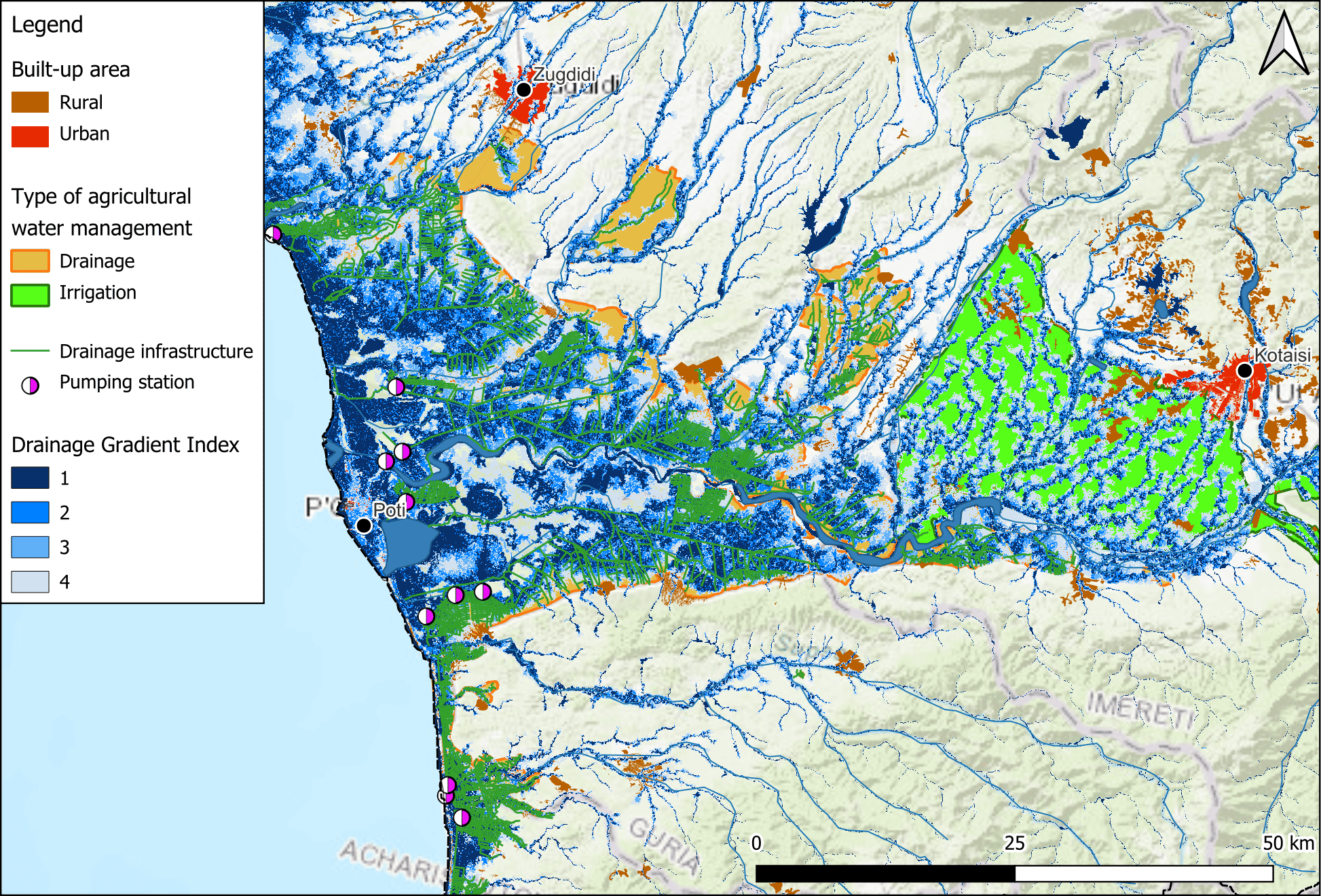
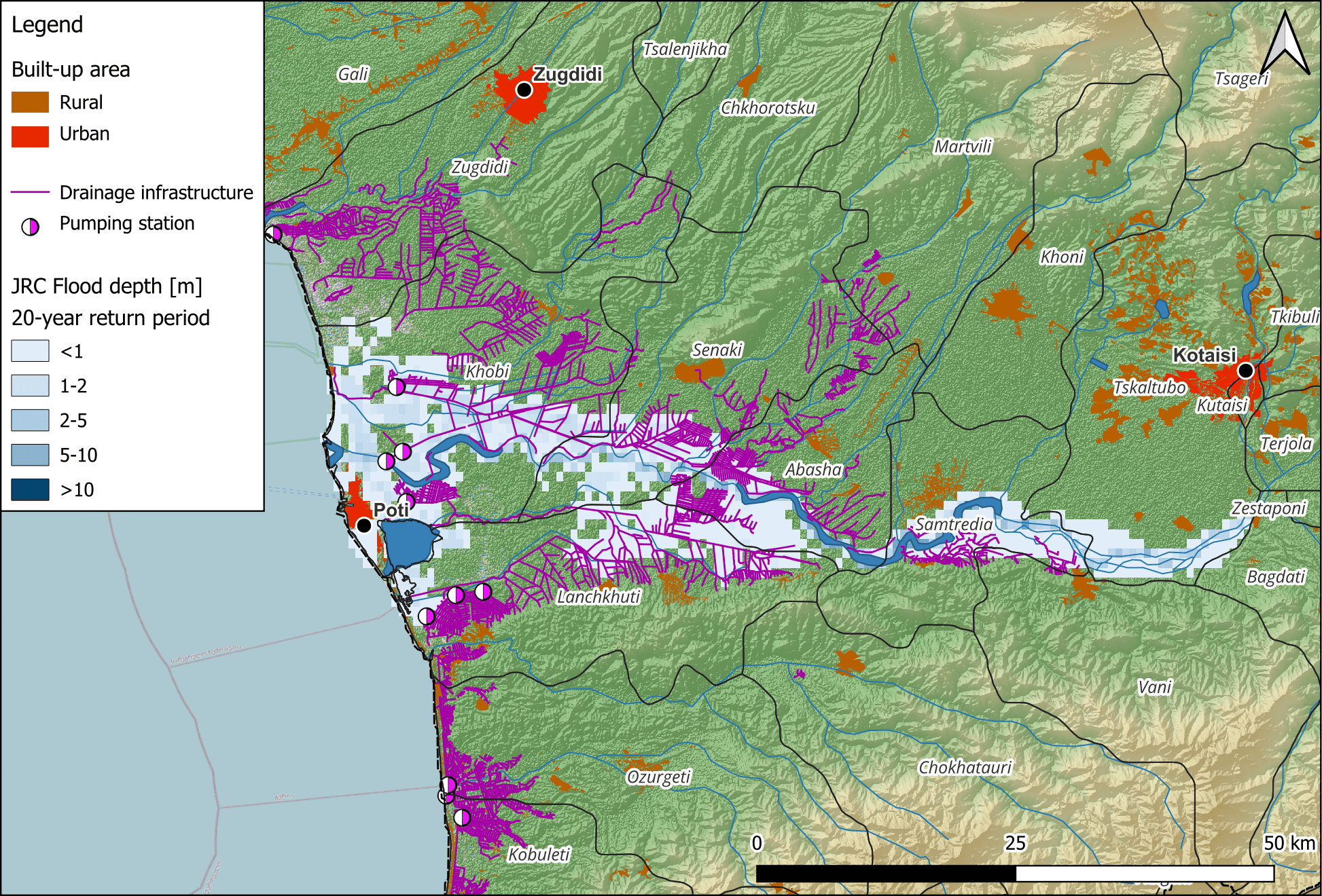
Climate change is expected to intensify extreme rainfall events, further stressing the outdated drainage systems and increasing flood risks. Additionally, institutional and legal challenges complicate effective drainage management, including fragmented responsibilities and funding constraints. Environmental considerations are also critical, as many of the drainage areas are adjacent to sensitive ecosystems, including the Kolkheti National Park and the Colchic Rainforests and Wetlands, a UNESCO World Heritage site.

This assessment will focus on evaluating the condition and performance of the current drainage systems in West Georgia, the potential and feasibility of their rehabilitation, analyzing the agricultural potential of rehabilitated land, assessing climate and environmental impacts, and identifying legal and institutional gaps. The findings will inform a feasibility study, providing strategic recommendations for rehabilitating and modernizing the drainage systems to enhance agricultural productivity, climate resilience, and environmental sustainability in West Georgia.