Held in Milano from 20 to 22 May 2026, FutureWater took part in the SOS-Water project consortium meeting.
Forty-four months into the project, and close to its end in September 2026, the Milano General Assembly meeting reviewed the progress and results derived from the application of the Safe Operating Space for Water in the project pilot basins of Rhine, Danube, Jucar and Mekong Delta. During the consortium meeting, and as part of the SOS-Water seminar series, research-professors Hector Macián-Sorribes and Manuel Pulido-Velázquez, both at IIAMA-UPV , delivered a webinar on the use of water-related indicators as key components for the quantification of water security and sustainability at the basin level.
During the meeting, several aspects were addressed relating to a) the integration and communication of uncertainty, b) the visualization of results through a dynamic, interactive and user-friendly web-dashboard, c) the presentation and communication of results to stakeholders through policy briefs, and d) the exploitation and sustainability of the methodology after the end of the project.
Within its scope of action, which focuses on the use of satellite data and the development of applications and EO-based services for SOS-Water, FutureWater, together with Eawag, presented the foundations upon which the next deliverable, “Recommendations for the promotion of Copernicus and GEOSS services”, will be based. The main barriers and recommendations developed by the European Water-ForCE project were discussed, and attendees’ views were gathered regarding the usefulness and potential of satellite services for improving the accuracy of key indicators used in the Operational Water Security Space at the catchment level.
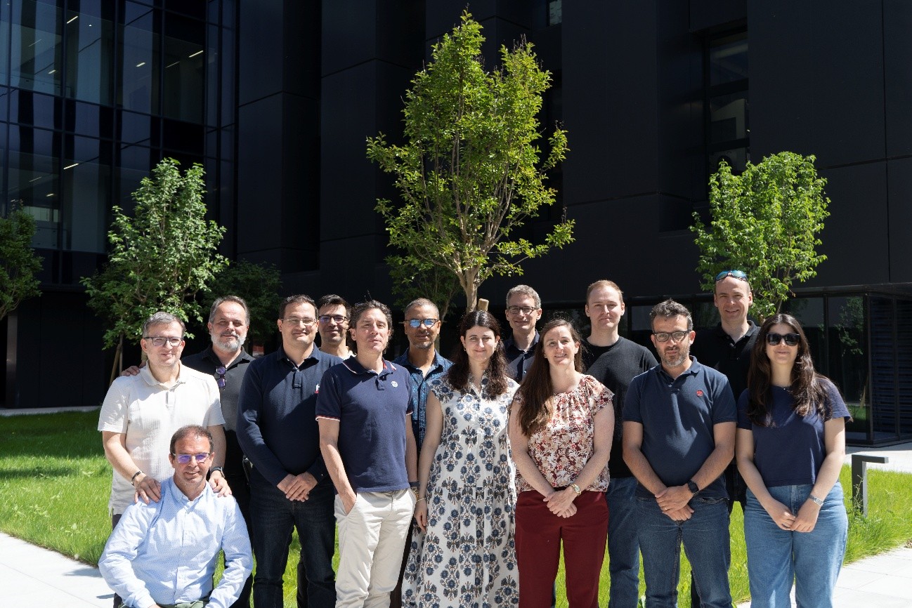
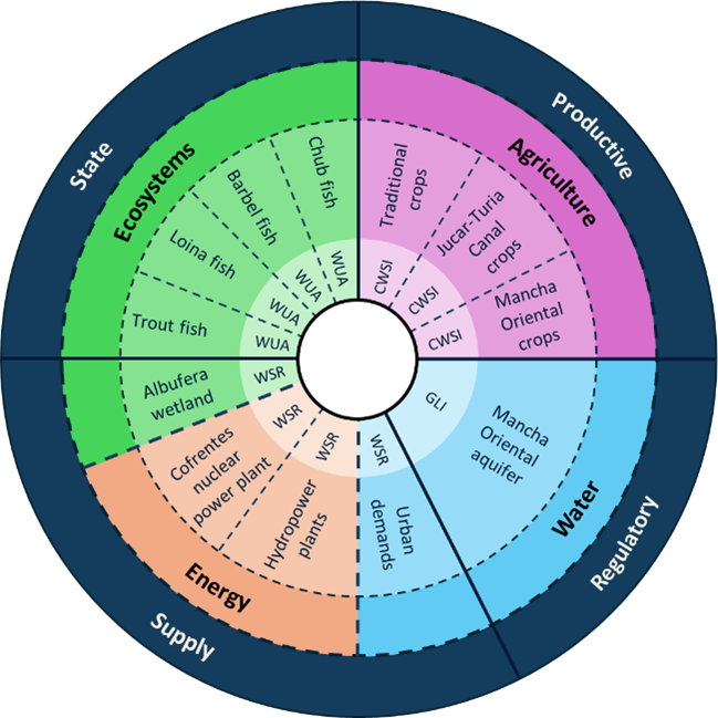
SOS-Water members who attended the consortium meeting held in Milan from 20–22 May 2026Set of domains of interest and indicators used in the Water Security Operational Space in the Júcar basin.Flowchart of the SOS-Water project used to define and quantify the Water Security Operational Space at the catchment level.
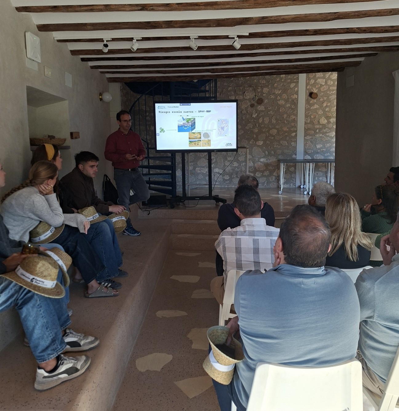
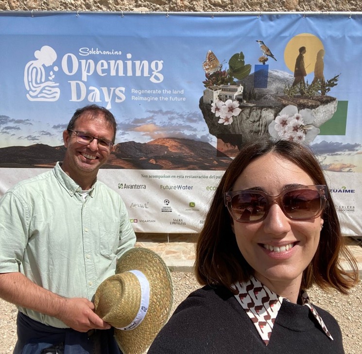
On 6 May, FutureWater played a prominent role at the “Solebromino Opening Days: Regenerate the land, Reimagine the future” event (4–10 May 2026, Huéscar – Spain), which brought together a wide range of activities centred on regenerative agriculture and the 4-returns approach as a driver of change and rural development in the Granada highlands region.
As part of its collaboration with Solebromino, FutureWater led a practical field workshop and took part in a panel discussion with other experts and stakeholders.
During the field workshop held at Solebromino’s Cubero farm, the FutureWater team highlighted the importance of developing a “Water Adaptation and Resilience Plan” to address this challenge. This plan must be built on four strong pillars:
a unified data management model,
a strong toolbox of modeling capabilities,
a robust training and capacity building program, and
a field monitoring and sensor system to measure the “health” and progress of the farm. These four pillars form the basis for a system capable of integrating the traditional knowledge of our environment with the most advanced science and technology.
During the practical session, our colleagues Sergio Contreras and Amelia Fernández demonstrated how, through the use of public data, we can improve the productivity of our farms by: a) identifying potential and actual risks of fertile soil loss, b) the precise identification of opportunities for water capture and harvesting, and c) the assessment of how and when to implement regenerative practices to improve our farm’s resilience to extreme droughts and heavy rainfall.
The practical workshop concluded with a field visit to the Cubero farm, where all attendees were able to check the benefits of several regenerative water-related practices already implemented by Solebromino, including infiltration ditches and ponds, stone walls, biodiversity ponds, revegetation strips in sensitive and degraded areas, and the maintenance of island-forests.
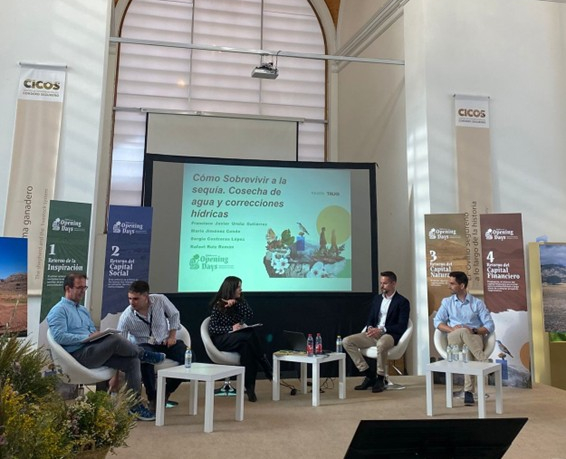
During the RegenTalks entitled “How to survive a drought. Water harvesting and water management practices”, held in the iconic CICOS building in Huéscar, Sergio shared with everyone the FutureWater’s international vision and experience with water and land conservation practices, nature-based solutions, and Payment for Ecosystem Systems as useful tools to value the conservation and restoration practices. Sergio highlighted the main challenges and opportunities facing farmers who wish to commit to more resilient and productive agro-ecosystems, such as those arising from climate change, the degradation of productive land, the loss of development opportunities and human capital in rural areas, the retention of qualified technicians, and administrative and institutional barriers, many of which stem from a lack of alignment between development and environmental policies.
We thank Solebromino for their trust in the FutureWater team. We hope this partnership continues to gain the momentum needed to demonstrate that rain-fed agriculture in this region can be viable, competitive and scalable.
Interested in making a difference, in the transformation? We can support you; write to us at s.contreras@futurewater.es
FutureWater at the talk and discussion session “How to survive a drought: water harvesting and water management measures” (Huéscar, 6 May 2026).
Sergio demonstrating the hydrological simulation tools used to detect hotspots of soil and water loss (Huéscar, 6 May 2026).Sergio Contreras and Amelia Fernández (FutureWater) at the Solebromino Opening Days (Húescar, 4–9 May 2026)
A scientific paper was recently published in Remote Sensing (doi: 10.3390/rs17111855) presenting the advanced technology developed by the MAGDA project, which integrates multiple sensor platforms and modeling tools to enhance agricultural weather forecasts and irrigation advisories.
This new research offers a breakthrough in precision farming by combining data from European satellites, drones, ground sensors, and GNSS signals for highly localized and accurate weather and soil moisture monitoring.
The MAGDA system provides significant advantages by improving short-term weather predictions and irrigation scheduling at the field scale, addressing challenges posed by climate change and extreme weather. Farmers gain access to precise information that helps optimize water use, reduce waste, and better protect crops from droughts, floods, and hailstorms.
One key component of the MAGDA system is IrriSPHY-1D, an advanced agro-hydrological model empowered by FutureWater embedded in MAGDA’s irrigation advisory service. IrriSPHY-1D accurately simulates soil moisture dynamics within the crop root zone, and compute Irrigation Water Requirement (IWR) more accurately than ever before. This enhanced capability enables farmers to optimize water application rates, and to reduce waste and minimize the environmental impact of irrigation practices.
The integration of MAGDA datasets —including high-resolution atmospheric data from Meteodrones, satellite soil moisture, and soil moisture retrievals via GNSS reflectometry— within IrriSPHY-1D significantly enhances irrigation advisories. This data fusion enables the system to provide more reliable and actionable irrigation forecasts, improving water management and resilience in agriculture.
With this innovative approach and scientific validation mark, FutureWater and MAGDA’s partners have made a significant contribution to advancing sustainable and climate-resilient farming practices across Europe.
On October 8 and 9, 2025, the 2nd Annual Meeting of the MegaWat project was held at the Institute of Science and Technology Austria (Klosterneuburg). MegaWat is an international initiative dedicated to assessing the impact of megadroughts on European high mountain regions. FutureWater, which is leading the Work Package on Resilience and Adaptation, presented progress on evaluating the impact of megadroughts on the water security of snow-dependent water-supply systems.
During the meeting, partners shared the latest developments in generating extreme climate scenarios using the CHELSEA algorithm for scaling climate forcings, hydrological modeling in high mountain zones with the T&C (Tethys-Chloris) model, and characterizing the behavior of snowmelt-dependent catchments. MegaWat is applied in three pilot regions: the Pyrenees (Aragón-Arga, Gállego, and Cinca-Segre), the Apennines (Tiber basin), and the Swiss Alps, allowing assessment of megadrought impacts on water security.
FutureWater updated the status of activities in Work Package on Resilience and Adaptation (WP4), highlighting advances in resilience characterization for the Spanish Pyrenees pilot. Here, the WEAP tool is used to quantify risks under extreme drought scenarios such as those experienced in Australia (1996–2010) and Chile (2010 and ongoing). Additionally, FutureWater has developed the “Resilience Calculator” tool and continues enhancing InfoSequia to provide early forecasts—key for efficient management of water for domestic, agricultural, and industrial supply.
MegaWat is currently at an intermediate stage. The meeting defined upcoming milestones focused on strengthening result transfer among teams, increasing stakeholder engagement, and publishing findings in high-impact scientific journals.
The project MegaWat has received funding from the Austrian Science Fund (FWF), Swiss National Science Foundation (SNSF), the Centre for the Development of Industrial Technology (CDTI), Dutch Research Council (NWO), National Research Council (CNR) and the European Union’s Horizon Europe Programme under the 2022 Joint Transnational Call of the European Partnership Water4all (Grant Agreement n°101060874)
I-DIP builds on InfoSequia, an advanced toolbox that integrates satellite data, local observations, and machine learning to monitor and forecast droughts. A new flash drought indicator, tailored to Pakistan’s climate, will be developed and embedded within NDMC’s existing system. The project will enhance early warning capacities, safeguard food and water security, and contribute to national climate adaptation efforts, paving the way for I-DIP’s upscaling across Pakistan.
Beyond monitoring, I-DIP will connect its forecasts to decision-making tools. Impact information will be disseminated through advisory bulletins and the inFarmer app (developed by WaterSprint), already widely used among farming communities. Field facilitators deployed by the Better Cotton Initiative will translate these insights into actionable guidance for farmers, enabling them to adapt irrigation practices, adjust cropping calendars, and mitigate potential losses. This integration of cutting-edge drought science with established communication networks ensures that early warnings are transformed into practical actions at the field level.
By embedding I-DIP within NDMC’s operational system, the project directly strengthens Pakistan’s early warning capacity for droughts, aligns with national climate policies, and supports the country’s commitments under the Sustainable Development Goals. In the longer term, the pilot is expected to catalyse scaling of I-DIP across Pakistan, offering authorities a state-of-the-art tool to anticipate and manage such extreme events.
FutureWater has concluded the first phase of a pioneering applied research project to support a safe and resilient transition in regenerative agriculture in remote rural areas of South Spain.
A resilient transition in regenerative agriculture involves a gradual shift from conventional practices toward systems that foster the conservation and restoration of soils, water, and biodiversity in agricultural landscapes, while stabilizing production and profitability as the system learns and adapts to climate and market shocks. Regenerative agriculture is not just about changing practices: it is a paradigm shift that recovers traditional practices and is able of absorbing, adapting, and transforming without failing.
The ultimate goal of the project, launched in early 2025 and funded by a leading company in the sector, is to adapt the brand’s farmland to improve agro-environmental assets through the effective implementation of interventions able to conserve water and avoid soil losses caused typically during intense rainfall events. The project evaluated the effectiveness of several adaptation portfolios resting on the combination of low-impact hybrid and green solutions (e.g., infiltration trenches, stone bunds, biodiversity ponds, or island forests).
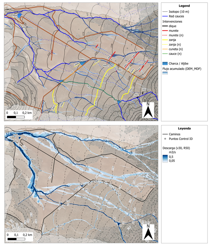
The demonstration study was carried out in a headwater catchment of the Guadalquivir River Basin located in the Alvelal region (SE Spain). The FutureWater’s recipe empowers the adoption of the best water management practices in the field based on pre-feasibility assessments which combine GIS and simulation tools able to identify and quantify hydrological risks across the landscape, and find the optimal location for the most cost-effective field interventions. The general framework offered to farmers provides analyses, guidelines and training for: (1) collecting and harmonizing spatial data and building their own QGIS projects, (2) identifying areas with high risk of water and soil loss, and (3) analyzing the hydraulic behavior of farmlands and their surroundings under intense rainfall, and the effectiveness of singular intervention or portfolios to reduce risks and improve environmental assets (Figure). To develop this pilot project and its components, free and open-source software tools were used, including QGIS, and hydrological-soil simulation models like SPHY and SIMWE.
The results of this pilot/demo exercise have proven promising and inspiring for strengthening rainfed regenerative agriculture initiatives in semi-arid environments, and highly useful for diagnosing vulnerabilities and risks, as well as planning resilient adaptation schemes that are both economically and environmentally sustainable.
Over the course of the project, which was successfully implemented in a 6-months period in a pilot area of 350 ha, several key outcomes were delivered including four technical reports, a QGIS project, and a comprehensive dataset with the outputs derived from the hydrological and hydraulic simulation exercises.
A second phase of the project is planned for next year, focusing on scaling-up of the approach across the whole farmland, transforming the simulation workflow into a user-friendly QGIS plugin, and training technical staff through courses and hands-on exercises with the project’s tools.
Map of evaluated interventions (top panel) and SIMWE model predictions of steady flow (m³/s) reached due to a maximum rainfall event of 50 mm/h (bottom panel).
The technical support draws on water resources modeling, drought early warning, and remote sensing, and is grounded in collaboration with knowledge institutions and policy stakeholders. The work also includes reviewing current practices among Member States, assessing environmental and socio-economic impacts, and identifying areas for improvement. Through this input, FutureWater supports the Commission in addressing complex questions around water resilience, while ensuring that scientific findings are translated into actionable insights for policy and planning.
The approach of FutureWater and Galayr is designed to be both scientifically rigorous and contextually grounded, ensuring that the developed drought model is locally relevant, sustainable, and fully integrated into existing national systems such as those of SODMA and NADFOR. The model will merge top-down (data-driven, machine learning-enabled) and bottom-up (stakeholder-informed) approaches, combining satellite data, climate indices, and indigenous knowledge to co-develop impact-based forecasts and consensus-based triggers for anticipatory action.
For the development of the drought forecasting model and the knowledge transfer we will focus on the following pillars:
A phased work plan that spans institutional capacity assessments, model development, validation, stakeholder consultations, and hands-on capacity building.
Application of state-of-the-art forecasting models ranging from ARIMA and regression to more advanced machine learning techniques, while maintaining focus on usability and institutional adoption.
A strong emphasis on knowledge transfer, including training programs and the establishment of a collaborative knowledge-sharing platform using the FutureWater Academy platform
A robust risk management plan, including mitigation strategies for data scarcity, stakeholder disengagement, and institutional turnover.
The international research project on Megadroughts in Europe’s Watertowers (project acronym MegaWat) officially launched with a kickoff meeting at the Institute of Science and Technology Austria (ISTA) the 4th and 5th September 2024.
The meeting brought together all project partners to discuss the research framework, methodologies, and collaborative goals. This project has received funding from the Water4All programme with co-funding from CDTI (Spanish Office for Science and Technology) and the EU’s Horizon Europe Framework Programme for Research and Innovation.
This ambitious project aims to advance the understanding of past and future megadroughts by integrating high-resolution climate reconstructions, tree-ring data, and hydroclimatic modeling. Researchers from Spain (FutureWater), Austria, Switzerland, Netherlands, and other countries, will work together to assess the frequency, drivers, and impacts of extreme drought events.
The kickoff meeting fostered interdisciplinary exchange, setting the foundation for effective collaboration over the coming years. With a strong focus on historical data and future projections, the project seeks to provide valuable insights for water resource management and climate resilience in a changing world.
Acknowledgements
This project has received funding from the Water4All programme with co-funding from CDTI (Spanish Office for Science and Technology) and the EU’s Horizon Europe Framework Programme for Research and Innovation.
Most recent research has focused on identifying historical megadroughts based on paleo-records and understanding their climatic causes, or on the study of “modern” events and their impacts, generally in lowland and plain regions. However, high-mountain regions and snow-dependent catchments have been little studied, and little is known about the impact of megadroughts on the state and dynamics of the cryosphere in mountain water towers.
In general, catchments dependent on high mountain systems have an intrinsic capacity to buffer the lack of precipitation and excess evapotranspiration that depends on the water reserves stored in the cryosphere (snow, glaciers and permafrost). It is presumed that the this buffer capacity is limited until a tipping point is reached from which the impacts of water shortages and temperature extremes may be amplified and jeopardize the functioning of ecosystems and water resource systems.
Megawat has a double objective: 1) to address the knowledge gaps around the hydro-climatic causes of extreme droughts and their impact on the water balance of Europe’s mountain water towers, with special emphasis on the concurrence of compound events and cascading and multi-scale effects and 2) to develop and propose new adaptation strategies to cope with the duration, extent and severity of future megadroughts and their potential impacts on environmental and socio-economic assets.
For its implementation, MegaWat focuses on Europe’s high mountain regions and their dependent-catchments. MegaWat aims to develop three products:
Product 1. A methodological framework for the identification and characterization of historical megadroughts during the instrumental period, and the assessment of the role of the cryosphere in supporting the landscape development of downstream areas, or in buffering climate change impacts. Product 1 relies on a combination of climate regionalization, surface energy balance modelling, hydrological simulation, and water evaluation and allocation analysis at the catchment level (figure below).
Product 2. A high-resolution, open-access regionalized climate database.
Product 3. A list of potential adaptation strategies useful for the prevention and mitigation of drought impacts, and the enhancement of the water security and resilience of high mountain regions and dependent catchments. These scenarios will be agreed with regional and local actors and stakeholders, and their effectiveness will be evaluated under extreme drought scenarios in three pilot regions in Europe. These pilot regions will be previously selected following criteria of representativeness, strategic importance and vulnerability to droughts.
Schematic representation of a high mountain basin, including the main components, processes and impacts related to droughts.
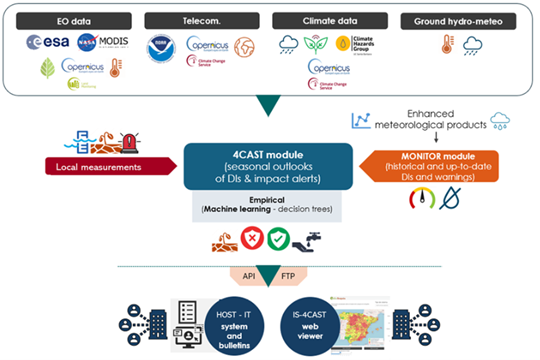
FutureWater plays an important role in MegaWat by coordinating the Work Package which aims to develop and test simulation tools that help to adapt to megadroughts and support the decision making process. Two specific objectives are pursued in this Work Package: a) the development of a methodological prototype for quantifying impacts and identifying tipping points for water security in snow-dependent downstream catchments, and b) the generation and the integration of snow drought indicators in the FutureWater’s Drought Early Warning System called InfoSequia (figure below).
Workflow of the InfoSequia Early Warning System developed by FutureWater and adapted for the detection of tipping-points of water scarcity in snow-dependent catchments. More information about InfoSequia.
This project has received funding from the Water4All programme with co-funding from CDTI (Spanish Office for Science and Technology) and the EU’s Horizon Europe Framework Programme for Research and Innovation.