
Within 3POLE4FOOD, FutureWater contributes to the assessment of long-term climate change impacts on water availability and crop production in major Asian river basins. The project combines  mountain hydrology modelling with downstream hydrology and crop production modelling to better understand how changes in snow, glacier melt, rainfall and temperature affect irrigation water supply and agricultural production.

FutureWater leads key technical activities related to climate forcing, bias-correction of meteorological dataset and the generation of climate change scenarios. Together with Hydrominds and Wageningen University we perform glacio-hydrological modelling and the analysis of upstream–downstream water linkages. Using the SPHY model, historical and future streamflow from mountain areas, including the contributions from rainfall, snowmelt and glacier melt are simulated. These outputs are coupled with the LPJmL model to assess downstream water availability, irrigation demand, crop yields and crop water productivity under future climate and socio-economic scenarios.

The project provides a scientific basis for identifying at-risk areas and understanding where agricultural systems may become more vulnerable to changes in mountain water supply. By linking climate, hydrology and food production, 3POLE4FOOD supports evidence-based planning for resilient river basins and sustainable food systems in Asia.
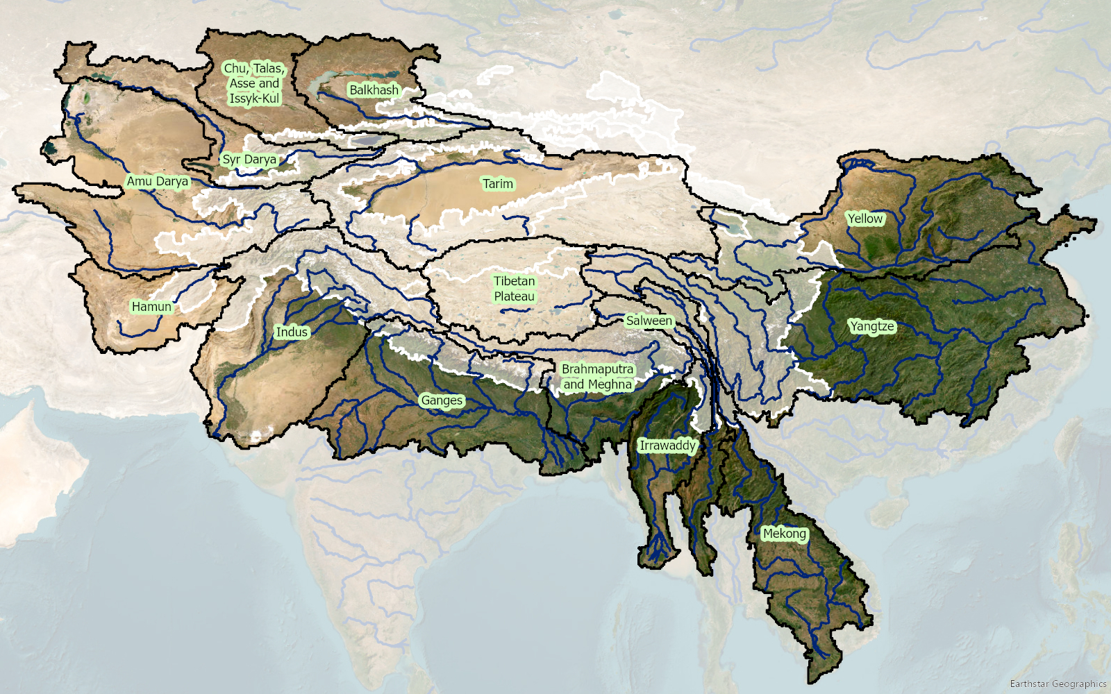

River basins originating in High Mountain Asia included in the 3POLE4FOOD project. The white polygon indicates the high mountain parts.

As one of the most climate-vulnerable countries and heavily dependent on the Indus River system for agriculture, Pakistan faces growing risks from rising temperatures, shifting precipitation, and increasing seasonal variability in snow and glacier melt. Modelling of climate change scenarios indicates that, under a business-as-usual pathway, these pressures will pose serious threats to farmer livelihoods and the wider agricultural sector. Reliable, transparent, and sector-disaggregated information on where water comes from, how it is stored, and how it is consumed is essential for shifting the basin toward a more resilient and sustainable water management pathway.

With support from FAO, the project will develop a water accounting system that maximizes the use of satellite remote sensing, complemented by in-situ data for inputs and validation. The work covers four key outputs:

  1. Critically reviewing existing draft water accounting reports and training materials produced by stakeholders, identifying gaps in methodology and datasets
  2. Developing a holistic WA methodology that accounts for available water resources, changes in storage, outflows, water use, and demand across agricultural, industrial, domestic, and environmental sectors
  3. Building a calibrated and validated water accounting system of models and codes, based on free and open-source software, capable of generating water accounting results for the Indus Basin and two provinces
  4. Producing water accounting reports for the Indus Basin, Punjab, and Sindh, including historical supply-demand gaps, water balances, and spatial distribution maps.

To ensure the system is sustainable and locally owned, FutureWater will deliver comprehensive hands-on training to government officials, enabling them not only to run the models but also to understand the underlying theory and modify the system in the future. By integrating advanced hydrological modelling, energy-based evapotranspiration estimation, and the latest land use classification, the resulting water accounting system will provide the Government of Pakistan with a powerful, replicable tool to support climate-resilient agriculture and water management across the Indus Basin.

I-DIP builds on InfoSequia, an advanced toolbox that integrates satellite data, local observations, and machine learning to monitor and forecast droughts. A new flash drought indicator, tailored to Pakistan’s climate, will be developed and embedded within NDMC’s existing system. The project will enhance early warning capacities, safeguard food and water security, and contribute to national climate adaptation efforts, paving the way for I-DIP’s upscaling across Pakistan.

Beyond monitoring, I-DIP will connect its forecasts to decision-making tools. Impact information will be disseminated through advisory bulletins and the inFarmer app (developed by WaterSprint), already widely used among farming communities. Field facilitators deployed by the Better Cotton Initiative will translate these insights into actionable guidance for farmers, enabling them to adapt irrigation practices, adjust cropping calendars, and mitigate potential losses. This integration of cutting-edge drought science with established communication networks ensures that early warnings are transformed into practical actions at the field level.

By embedding I-DIP within NDMC’s operational system, the project directly strengthens Pakistan’s early warning capacity for droughts, aligns with national climate policies, and supports the country’s commitments under the Sustainable Development Goals. In the longer term, the pilot is expected to catalyse scaling of I-DIP across Pakistan, offering authorities a state-of-the-art tool to anticipate and manage such extreme events.

With the highest rate of urbanization in South Asia and as one of the most vulnerable countries to climate change, Pakistan faces a range of complex challenges, including more frequent and intense flooding, declining economic productivity, and deteriorating public services. Growing dependence on groundwater, coupled with insufficient surface water recharge, is leading to severe localized groundwater depletion.

With support from the Asian Development Bank, the Government of Pakistan aims to upgrade and expand water and sanitation infrastructure in the cities of Sargodha and DG Khan, both of which face significant climate change-related challenges that impact combined drainage and sewer networks. The project has three major outputs:

  1. improving climate-resilient urban infrastructure and services,
  2. enhancing institutional capacity, operational efficiency, and gender inclusiveness of service providers, and
  3. creating greater economic empowerment opportunities for women in the WASH sector.

To assess the exposure and vulnerabilities of project components to potential climate risks, FutureWater will utilize advanced downscaled Coupled Model Intercomparison Project Phase 6 (CMIP6) ensembles, along with relevant hazard data and local information, to conduct a detailed Climate Risk Assessment (CRA). The insights gained will enable the Asian Development Bank (ADB) to implement effective adaptation measures and ensure climate-resilient development.

Currently, Pakistan’s energy mix consists of 58.8% thermal, 25.8% hydel, 8.6% nuclear, and 6.8% alternative sources, reflecting efforts to diversify from fossil fuels. Pakistan’s installed electricity generation capacity reached 41,557 MW by 2022, with significant growth in transmission line length over the past 5 years. However, the T&D system has not kept pace with the nearly 15,000 MW capacity added during 2017-2021 (ADB, 2024). Despite investments, transmission and distribution losses averaged about 18% over the last 5 years, exceeding the National Electric Power Regulatory Authority’s (NEPRA) 15.3% target. In 2020, 23.7% of generated energy was lost during transmission, distribution, and delivery (ADB, 2024). Notably, transmission and distribution losses exceed 25%, far higher than in comparable countries (GoP, 2017). Therefore, there is an urgent need to upgrade the existing distribution infrastructure to fulfill the energy demands and ensure steady socioeconomic development in the country. ADB will provide financing for four underperforming DISCOs, selected in consultation with the Ministry of Energy: Sukkur Electric Power Company (SEPCO), Hyderabad Electric Supply Company (HESCO), the Multan Electric Power Company (MEPCO), and the Lahore Electric Supply Company (LESCO) to:

  1. to upgrade the critical infrastructure of these DISCOs to reduce technical losses.
  2. to implement revenue protection measures to improve collections. Additionally, the project design includes embedded climate resilience and reform measures to enhance institutional capacity and financial sustainability.

These rehabilitation efforts will also take into account and address the growing impacts of climate change in four DISCOs. FutureWater will make use of state-of-the-art downscaled Coupled Model Intercomparison Project Phase 6 (CMIP6) ensembles, and other relevant hazards and local information to develop this CRA. Insights from the CRA will be used to devise adaptation strategies. Additionally, FutureWater will be reviewing the existing meteorological monitoring network and recommending additional potential monitoring sites for improved surveillance in the country. To further assist the Government of Pakistan, in actualizing its second Nationally Determined Contribution (NDC) agenda which seeks to reduce greenhouse gas (GHG) emissions per unit of GDP by 50% (compared to the level in 2016), by the year 2030, FutureWater will also develop a GHG account and prepare a Paris Agreement alignment assessment.

The project prepares robust climate mitigation and adaptation pipelines aligned with the Paris Agreement and responsive to DMCs climate change priorities. The TA will support interventions on departmental, sectoral and country levels with key activities including development of a regional strategy, upstream climate assessments, climate pipeline development, government dialogues and capacity building. As part of this project, FutureWater conducts a regional climate risk assessment for ten countries. This includes an assessment of baseline and future climate hazards, exposure and vulnerability and addressing sectoral impacts and adaptation options for a wide range of sectors. In addition country profiles summarizing climate risks for the ten countries are generated. The reginal climate risk assessment feeds into the climate strategy.

Countries in Asia and the Pacific region are significantly exposed to disaster risks from various hazards and are on the frontline of a climate emergency. Studies suggest that 80% of the globally affected people belong to the Asia-Pacific region, thus emphasizing the critical need for an effective multi-hazard EWS.

EWS, a cost-effective tool for saving lives and reducing economic losses, is particularly crucial for frequent and hazardous weather, water, and climate events. However, despite advancements in the four EWS components, major gaps persist, with implementation lagging and limited coverage in frontline countries, including least developed countries (LDCs) and small island developing states (SIDS). As of 2021, only 50% of countries in Asia and the Pacific reported having multi-hazard early warning systems (MHEWS), emphasizing the need for support.

The culmination of these efforts will be encapsulated in a scoping report, documenting the results of the project, including consultations with key partners and stakeholders during the Regional Workshop on Increasing Investments in Early Warning Systems, to be held in February 2024 in Bangkok, Thailand. The study will offer a comprehensive summary of the EWS scoping, encompassing the policy and institutional landscape, status, initiatives, and investments, as well as residual gaps for regional and national EWS programming in selected DMCs. Additionally, this study will provide guidelines for the implementation and operationalization of the proposed EWS facility, along with initial investment concept notes based on EWS priorities at regional and/or national levels. This holistic approach aims to contribute substantively to the strengthening of EWS capacities, fostering resilience in the face of increasing disaster risks across the region.

Pakistan is ranked as the 8th most climate vulnerable country in the world as per the Global Climate Risk Index (2019) and in recent years has been facing the worst brunt of climate change. Irregular and intense precipitation, heatwaves, droughts, and floods have severely impacted the agriculture and water sector. Approximately, 90% of the country’s freshwater resources are utilized by the agricultural sector. However, lack of information services makes it a challenge to implement a water accounting system for improved water resources management.

The GCF funded project titled “Transforming the Indus Basin with Climate Resilient Agriculture and Water Management” aims to shift agriculture and water management to a new paradigm in which processes are effectively adapting to climate change and are able to sustain livelihoods. FAO Pakistan, as per the request of the Ministry of Climate Change, has designed the project to develop the country’s capacity to enhance the resilience of the agricultural and water sector. There are three major components:

1. Enhancing information services for climate change adaptation in the water and agriculture sectors
2. Building on-farm resilience to climate change
3. Creating an enabling environment for continued transformation

FutureWater will be actively involved in Component 1 which focuses on facilitating the development of a water accounting system and improving the availability and use of information services. Given the limited data availability in the region, FutureWater will integrate the use of remote sensing technologies within the existing Water Accounting methodology to address this gap. A capacity and needs assessment will be conducted and a series of tailor-made trainings will be designed subsequently to enable key government stakeholders to use open-source geospatial analysis tools as well as models to estimate real water savings, particularly in the context of agriculture. The trainings will help build the country’s capacity to implement water accounting at different spatiotemporal scales and cope with the worsening impacts of climate change.

The SREB is part of the Belt and Road Initiative, being a development strategy that focuses on connectivity and cooperation between Eurasian countries. Essentially, the SREB includes countries situated on the original Silk Road through Central Asia, West Asia, the Middle East, and Europe. The initiative calls for the integration of the region into a cohesive economic area through building infrastructure, increasing cultural exchanges, and broadening trade. A major part of the SREB traverses Asia’s high-altitude areas, also referred to as the Third Pole or the Asian Water Tower. In the light of the planned development for the SREB traversing the Third Pole and its immediate surroundings, the “Pan-Third Pole Environment study for a Green Silk Road (Pan-TPE)” program will be implemented.

The project will assess the state and fate of water resources in the region under following research themes:

1. Observed and projected Pan-TPE climate change
2. Impacts on the present and future Water Tower of Asia
3. The Green Silk Road and changes in water demand
4. Adaptation for green development