![]()
Introduction
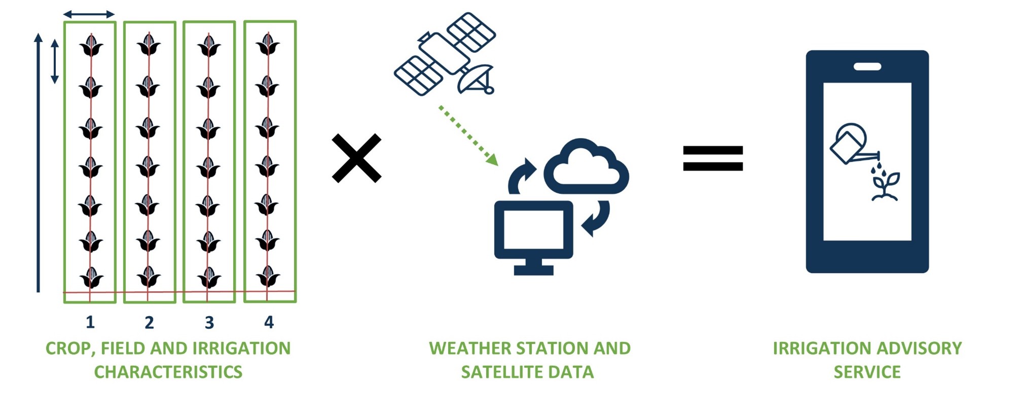
Croptimal brings together FutureWater’s proven digital farming tools into one powerful platform with two integrated modules: Irrigation (formerly SOSIA) and Crop Suitability. Together, they deliver precise, location-specific insights to guide farmers and decision makers on what to plant, where to plant, when to plant, and how much to irrigate—maximizing yields while ensuring sustainable water use.
By combining advanced weather, soil, crop, and satellite data, Croptimal transforms complex scientific information into clear, practical advice. Users receive up-to-date, field-level recommendations on crop selection, planting schedules, and irrigation management—all tailored to local conditions and continuously refined as new data becomes available. This seamless integration bridges the gap between data-driven modeling and on-the-ground agricultural decision-making.
Croptimal is more than a digital tool—it’s an operational service empowering farmers, agronomists, and intermediaries with actionable insights. By uniting long-term suitability planning with in-season irrigation guidance, it helps increase productivity, improve water efficiency, and build climate-resilient farming systems across diverse landscapes.
The Croptimal app is available at Croptimal.app. Get in touch with us if you would like more information or to request your own account.
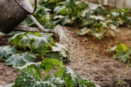
Irrigation (formerly SOSIA)
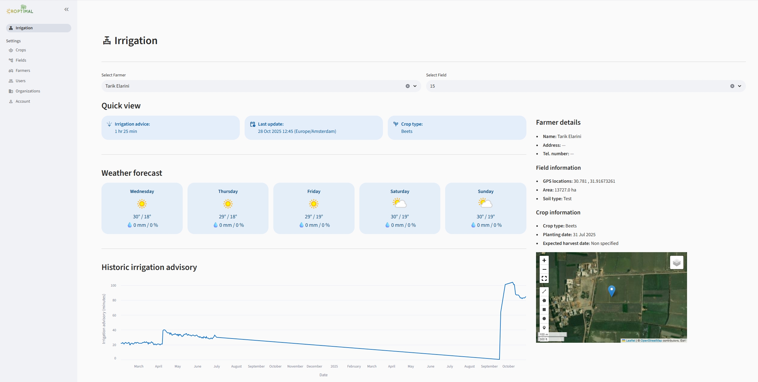
The Irrigation module is a cutting-edge advisory service for smallholder farmers, piloted in Rwanda, Zambia and Ghana. It provides precise, field-specific guidance on when and how long to irrigate, improving water efficiency and crop productivity while remaining simple and affordable to use.
Video: Croptimal – Smart Irrigation Advice Powered by Data
Video: Croptimal in Ghana
Key Features
- Virtual Weather Stations (VWS) via Google Earth Engine: real-time and historical weather insights in data-scarce regions without local hardware or storage.
- Tailored crop-specific schedules: integrates FAO-WaPOR ETref and GPM rainfall; dynamically refines Kc using Sentinel-2 to match actual crop development.
- Dynamic hindcast updates + rainfall forecast integration: weekly schedule updates reflect recent weather and forecasted rain for robust, climate-smart irrigation.
- Precise run-times: considers pump capacity and dripline flow to calculate exact irrigation duration.
- Convenient WhatsApp updates: daily advisories and short-term forecasts delivered at the user’s preferred time.
Empowering Farmers and Extension Officers
The module was co-developed with Holland Greentech, ensuring a strong focus on practical usability and farmer impact. It is securely hosted for intermediaries—such as extension officers—who can deliver up-to-date irrigation schedules directly to farmers through print or WhatsApp. The platform offers affordable, user-friendly access without the need for advanced hardware or technical expertise, making it ideal for smallholder farmers operating in data-scarce regions.
Feedback from users has led to significant improvements, including expanded crop coverage (e.g., leafy vegetables and pulses), a farmer database that simplifies data entry, and performance optimizations for low-bandwidth environments. The system provides localized, field-specific advice that adapts to each crop and weather condition, with continuous updates throughout the growing season to ensure farmers always receive the most relevant recommendations.
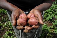
Crop Suitability
How It Works
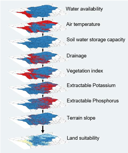
The module integrates satellite-based data products, weather information, machine learning and crop growth modeling. High-resolution spatial data—rainfall, air temperature, crop evapotranspiration, soil properties, vegetation indices and terrain—are analyzed to evaluate land suitability from regional to field scale. Historical climate informs long-term patterns; optional extensions include coupling seasonal forecasts for dynamic services.
It supports strategic planning at regional scale as well as practical, field-level planting decisions.
Key Features
- Crop-specific thresholds to identify conditions needed for optimal yields.
- High-resolution mapping at 100-meter resolution for actionable local insights.
- Seasonal windows with recommendations for multiple planting seasons (e.g., Oct–Dec, Mar–Jun, Nov–Apr).
Results
Outputs include clear, location-specific planting recommendations classified as:
- Very suitable: minimal limitations; minor interventions needed.
- Suitable: moderate limitations; standard interventions required.
- Not ideal: significant limitations; major interventions recommended.
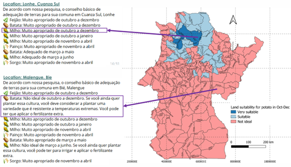
For “Not ideal” land–season combinations, Croptimal suggests actionable field management options, such as resilient varieties, irrigation or drainage strategies, and targeted fertilization—always tailored to local agronomy. Initially introduced in Angola and Egypt, the module is expanding rapidly to new geographies, crops and data layers.
Related projects
-
Smart Sprayer: Efficient Terrace Irrigation in Nepal
The project introduces the Smart Sprayer package, an integrated solution that combines: 1) A low-cost, gravity-fed micro-pivot irrigation system (the Sprayer), designed to function under very low water pressure and flow—ideal for hilly terrain and remote farms. 2) A mobile-based Smart Irrigation Tool that sends farmers daily, crop-specific irrigation recommendations...
-
Safe Sowing Windows for Horticulture in Ghana
How do farmers know when to plant their seeds? In Europe, farmers rely on high-quality weather data to determine optimal planting dates. In Africa, however, weather stations are scarce, resulting in poor rainfall predictions. This is particularly problematic for farmers in tropical regions, where start of the rainy season determines...
-
BUCRA: Building Unity for Climate Resilient Agriculture
The BUCRA project empowers smallholder farmers in Egypt’s Nile Delta with climate-smart agricultural practices and advanced digital tools. Using FutureWater’s Croptimal and SOSIA, the project optimizes crop selection and irrigation efficiency, addressing water scarcity and climate change. Demonstration plots and tailored training drive sustainable, resilient farming.
-
SOSIA+: Climate Smart Irrigation Services in Ghana
Earlier this year FutureWater finished a very first draft of the irrigation advisory application SOSIA, with promising results in Rwanda and Zambia. The SOSIA Irrigation Advisory Tool was based on satellite data only. For this project, the SOSIA+ tool will be developed. SOSIA+ will also include real-time local ground data...
-
SOSIA: Small-Scale Open Source Satellite-based Irrigation Advice
FutureWater currently furthers the development of the SOSIA tool: an irrigation advice for small-scale food producers. Due to the lack of local weather station data, virtual weather stations derived from open-source satellite data are established, and combined with crop stage, and projected and historical precipitation data. The SOSIA tool allows...
-
Mavo Diami: Services on Land-crop Suitability Mapping and Operational Irrigation Advice in Angola
The overall project goal is to improve sustainable food and income security for >100,000 smallholder farmers in Angola, by accelerating their agri-business performance through informed decisions supported by the Mavo Diami services built on weather, soil and crop signals and other relevant data and indicators. Ensuring the services are offered...
-
Remote Sensing for Land Suitability Assessment in Angola
The government of Angola considers the agricultural sector as an economic sector that offers great prospects and therefore aims to further develop the agricultural sector in order to diversify its economy. The potential for expanding the area under production is great. To support the effective planning of interventions that increase...