
Concept
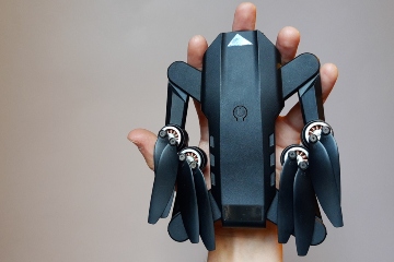
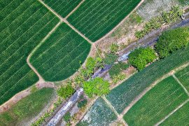
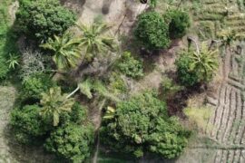
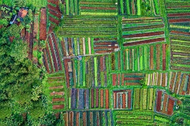
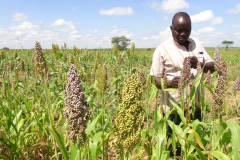
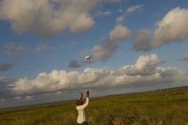
Most Sub Saharan farmers have limited resources and no access to farm data. Appropriate information at the right location and timing is essential for these farmers to make decisions regarding application of their limited resources such as water, seeds, fertilizer and labour. FutureWater has therefore developed a service using low-cost flying sensors in a development context to ensure that farmers will get information at their specific level of understanding and simultaneously develop a network of service providers. The flying sensors provide valuable high-resolution information, using near-infrared, thermal and visual imagery to detect crop stress in farm fields. Near-infrared light is not visible to the human eye, but provides information on the status of the crop about 10 days earlier than that yielded by the red-green-blue spectrum that is visible to the human eye. Based on the images, which have a resolution of about 2 cm/pixel, farmers can take decisions on where to do what in terms of irrigation, fertilizer application and pesticides.
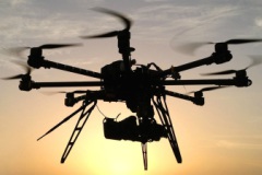
With flying sensors (drones) we can provide this essential information:
- At an ultra-high spatial resolution
- At an unprecedentedly flexibility in location and timing
- At a spectrum outside the human eye
- At an in-country business oriented approach
We are convinced that this innovation is a game changer comparable with the introduction of mobile phones that empowered farmers with instantaneous information regarding markets and market prices. With information from flying sensors they can also manage their inputs to maximize yields and simultaneously reduce unnecessary waste of resources. Instead of relying on common-sense management, farmers are now able to take decisions based on facts, resulting in an increase in water productivity. In summary, the flying sensors close the missing link to agronomic information on where to do what and when, leading to more crop per drop!
FutureWater applications
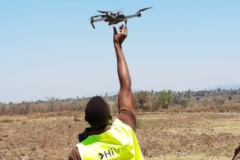
Over the past years we have successfully set-up operational flying sensor services for smallholder farmers in Kenya and Mozambique. At present we serve thousands of farmers at multiple locations through a network of local operators. Our business model pinpoints the need to set up independent, self-standing companies in African countries, as already accomplished in Kenya and Mozambique. These companies employ local agronomists who are trained in using flying sensors to go to farmers’ fields, conduct flights, analyze the images and use these to provide advice to farmers, for which they get paid directly.
Right now we are working on integrating thermal cameras with the flying sensors to specifically detect water related crop stress and are developing online portals through which all the flying sensor maps are made available. One of these portals can be found here.
Our In-House Tools & Services
Rapid Eye XS: Real Time In-field Advisory Drone Camera
The Rapid Eye XS is our self-made affordable, lightweight camera module that provides real-time NDVI maps for precision agriculture. By enabling instant crop health insights and on-the-spot advisory services, it helps farmers optimize water use, detect pests early, and improve yields sustainably.
Related projects
-

Integrated Water Resources Management in Tajikistan
Given the abundant freshwater resources in Tajikistan, water plays a crucial role in the country's socioeconomic development. However, the rising population, economic growth, and the growing impacts of climate change pose significant challenges to ensure water availability and accessibility. This project aims to address the aforementioned information gap by improving...
-
HiFarm: Data Driven Agricultural Intensification Pilot Program for Maize, Coffee and Tea Farmers in Kenya
The eco.business Fund, in partnership with FutureWater and Export Trading Group (ETG), one of the largest integrated agricultural supply chain managers and processors in sub-Saharan Africa, has launched a pilot project in Kenya for data-driven agricultural intensification. This project aims to improve farmer productivity and profitability whilst enhancing the environmental...
-
A Practical Farmers’ Toolkit – Geodata for Climate Smart Agriculture in Egypt
The 'Farmers Toolkit' as presented in this project contains various geodata tools applicable for farmers to assist their decision-making and adopt climate smart agricultural practices. This project launches a training program on these tools, which are: Flying Sensors, irrigation advisory services (IrriWatch portal), WaPOR and Google Earthengine Apps, and Climate...
-
Tailor-made Advice and Training on Flying Sensors for Agriculture in Jordan
This online training was provided over a period of 8 weeks for 25 participants selected by NARC (National Agricultural Research Centre) Jordan. The online training consisted of self-paced exercises and regular live (video) sessions provided through the OpenCourseWare website of IHE Delft. The four modules provided in this training will...
-
Cadastre Mapping with Flying Sensor Imagery in Mozambique
In this project TerraFirma hired FutureWater, HiView and ThirdEye Limitada (Chimoio, Mozambique) to acquire flying sensor imagery over a pilot area near Quelimane, Mozambique. The objective of this pilot project is to determine the suitability of using flying sensor imagery for cadastre mapping in an area of small-scale agriculture in...
-
Tailor-Made Training on Crop Models and Remote Sensing for Water Management in Agricultural Systems
FutureWater, HiView and ThirdEye Kenya have partnered with Egerton University (Crops, Horticulture & Soils Department) to conduct a tailor-made training on 'Crop models and remote sensing for water management in agricultural systems'. This training project is funded by the NUFFIC - TMT program.
-

Determining biomass potential with Lidar point cloud of the Netherlands
This MIT feasibility project investigates the opportunities of an innovation project for determining the biomass potential from local nature management and green maintenance using the publicly available Lidar point cloud of the Netherlands. If the results are positive, this may lead to an innovative logistics support service where producers and...
-
Preventing frost damage in fruit cultivation by thermal imaging with flying sensors
This feasibility project investigates the opportunities of an innovation project for monitoring the effectiveness of wind machines as a frost protection measure in fruit cultivation using flying sensors (drones) equipped with a thermal imager. The results of this feasibility project may lead to an innovative information service to fruit growers...
-
Incorporating Flying Sensors to Increase Agricultural Productivity in Central Mozambique
The PROMAC II project is an ongoing project of NCBA Clusa introducing conservation farming practices to various locations in the Manica, Tete and Zambezia provinces, with the objective to increase agricultural productivity. This project incorporates flying sensor activities in the PROMAC II project as a M&E indicator of the practices...
-
APSAN-Vale: Piloting Innovations to Increase Water Productivity and Food Security in Mozambique
The project has as its overall aim to increase climate resilient agricultural productivity and food security, with a specific objective to increase the water productivity and profitability of smallholder farmers in Mozambique, prioritizing small (family sector) farmers to increase food and nutritional security. This project will demonstrate what the best...
-
TWIGA: Transforming Weather Water data into value-added Information services for sustainable Growth in Africa
TWIGA aims to provide actionable geo-information on weather, water, and climate in Africa through innovative combinations of new in situ sensors and satellite-based geo-data. With the foreseen new services, TWIGA expects to reach twelve million people within the four years of the project, based on sustainable business models. The TWIGA...
-

Water Productivity mapping using Flying Sensors and Crop Modeling
The objective of this pilot study was to achieve plot-level maps of water productivity and yield to test a methodology to assess the performance of different farmers in order to provide them with recommendations to improve water productivity. More specifically, this pilot study combined high-resolution imagery from Flying Sensors with...
-
Flying Sensors for Ultra-High Resolution Flood Risk Identification at Local Scales
The outputs of this project can be summarized as providing real time dike and levee information at local scales (up to 10,000 ha) that is collected, analysed and used at the same local scale. The output is divided into two components. First, the Flying Sensor information will be used for...
-
ThirdEye: Flying Sensors to Support Farmers’ Decision Making
The ThirdEye project supports farmers in Mozambique and Kenya with their decision making in farm and crop management by setting up a network of flying sensors operators. Our innovation is a major transformation in farmers’ decision making regarding the application of limited resources such as water, seeds, fertilizer and labor....
-

OWASIS-UK: Observatory of Water Availability – System of Integrated Services
The main objective of this study is to explore the potential to combine optical and gravity data from Earth Observation with meteorological data, together with innovative in situ sensors, hydrological modelling and crowd sourcing technologies, and the advanced visualization of the information through situation awareness platforms and decision support tools,...