The aim is to develop a business case for a Watershed Investment Program for Addis Ababa. It includes stakeholder and governance analysis, scientific modeling, return on investment (ROI) analysis, and an implementation plan. Hydrological models are employed to assess the potential of Nature-based Solutions to mitigate the negative trends in the watershed, and improve water supply reliability, water quality, sedimentation and agricultural productivity. The study should raise awareness for all key stakeholders and potential investors. The study is performed under the Nature for Water Facility launched by The Nature Conservancy.
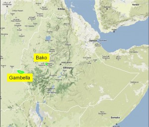
The Gambella farm covers a truly vast area of 130,000 ha. Savannah land is currently under phased reclamation. In 2010, approximately 5,000 ha of dryland paddy are expected to be sown in. A palm oil nursery has been set up to support a 20,000 ha irrigated plantation in the near future. The planning on crop types, cropping calendar and crop locations is under progress. Aspects such as drainage, irrigation, flooding, crop water requirements, and water availability should be explored first and will form the basis of the crop selection processes.

Considering the size of the farm, and its option to expand with another 170,000 ha a robust regional scale hydrological model should be developed that could be used for multiple planning purposes. A hydrological model can be used to show the Ethiopian Government that good water management practices are in use on the farm with little impact to the vegetation. With these types of advanced information systems in place, Karuturi will be able to show that a highly efficient agricultural water use system is being implemented in the Gambella region without adverse impacts on regional scale hydrological processes. Proper attention to precious water resources and environment will create credits from various national and international stakeholders.

The Nile Basin Decision Support System (NBI-DSS) will provide the necessary knowledge base and analytical tools to support the planning of cooperative joint projects and the management of the shared Nile Basin water resources on an equitable, efficient and sustainable manner. FutureWater was asked to support this NBI-DSS and to undertake preliminary data collection and compilation.
Details
The developed data base has two main components: spatial data and point data. Regarding the spatial data the following data have been made available
- Land cover
- Soils
- Vegetation Indices
- Precipitation FEWS
These data are available over the entire Nile Basin and include a extensive set of attributes. Data have been quality controlled and is ready to apply in the DSS and can be used for various types of hydrological models.
The point data includes over 20 million records from various sources included global and local data sets. Data are stored in PostGreSQL. The data can be considered as the most complete hydro-meteorological dataset available for the Nile so far.
