Background
Due to a fast track development of irrigation schemes, Mexico has now critical and urgent water related problems including the overexploitation of surface water and groundwater resources in regions, where most of the population and most of the GDP is generated. The present situation is clearly not sustainable in the medium and long term. If not addressed soon, this situation will become an obstacle to continued economic development and will have serious social impacts including the possible abandonment of important parts of the country by significant parts of the population.
The National Water Law, amended in April 2004 mandates the development and implementation of Integrated Water Resources Management Programs (IWRMPs) in overexploited basins and aquifers, with the objective of achieving sustainable water resources management and use in these areas. The World Bank assists the Water Sector in Mexico with their formidable challenges to create sustainable conditions and keeping pace with rural economic development through various projects:
- Water Resources Management Project (PROMMA) 1996-2004
- Irrigated Agriculture Modernization Project (PMIR) 2004-2008
- Integrated Management of Basins and Aquifers Project (GICA) 2007-2010
- Water Rights Adjustment Project (PADUA) 2008-2011
Modern analytical tools such Remote Sensing, GIS and simulation models can help to swiftly obtain data to support the water management decision making process. A diagnosis of the Rio Bravo and Northern Central Aquifers has been made to demonstrate management options as well as how to obtain the minimally required data sets to base sound policy decision making upon.
Objectives
The objectives of this study funded by the Bank Netherlands Water Partnership are:
- Quantify differences between diversion, depletion and return flow in the irrigation sector, and show that these flows have different management options, and that ‘water use’ is a misleading terminology
- Show that improvement of local irrigation efficiencies only shifts the problem to downstream areas and does not form a solution for local scale sustainable water resources management
- Introduce concepts of evapotranspiration ET management and real water savings, i.e. restoring the water balance by reduction of comprehensive ET
- Quantify agricultural and environmental water consumption
- Create awareness of technical possibilities to derive strategic datasets from remote sensing measurements coupled with hydrological simulation models
Advanced computational tools
This study is a unique combination of the SEBALTM remote sensing model for energy and photosynthetic fluxes combined with the spatially distributed SWAT model developed by Texas A&M and ARS-USDA (Texas). SEBAL-based evapotranspiration fluxes are used to calibrate the plant and soil parameters for all hydrological response units though inverse model calibration and parameter optimization technology. This is a powerful calibration philosophy that goes far beyond the classical approach of calibrating a catchment scale model with flows measured at one gauging station. The traditional approach does not ensure that the water flows throughout the basin are well simulated. The figures below demonstrates that we have overcome this problem.
Study areas
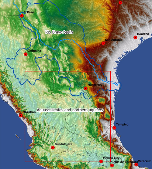
The Rio Bravo is selected as an example to develop fresh ideas on achieving sustainable water resources conditions. The Rio Bravo lies within North America’s largest desert, the Chihuahuan Desert. The Rio Bravo transverses across 5 states in Mexico (Chihuahua, Durango, Coahuila, Nuevo Leon and Tamaulipas) and 3 states in the US (Colorado, New Mexico, Texas). In addition to Rio Grande, similar remote sensing analysis have also been made for Aguascalientes and the Central Northern Aquifers.
Results
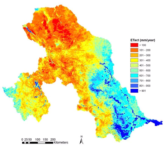
Result 1: Remote Sensing Rio Bravo
MODIS images have been used for the generation of the land use map. The same images are used as input into the SEBAL energy balance model to compute evapotranspiration (actual, potential, reference), biomass production and soil moisture. SEBAL is propriety software of WaterWatch. The rainfall map is derived from the TRMM passive microwave satellite.
View results
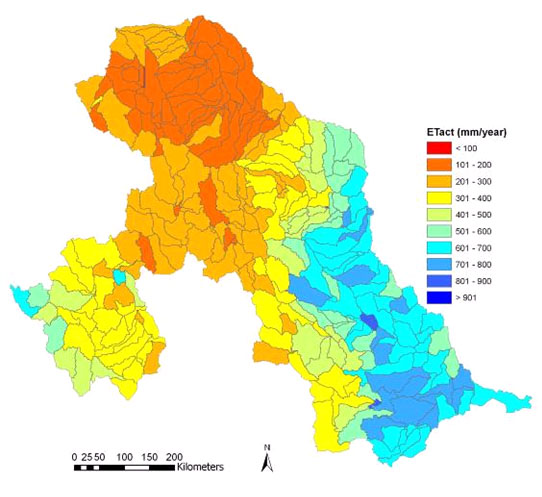
Result 2: SWAT results Rio Bravo
Click on the map to activate one of the 23 sub-basins and view the water balance. The water balance describes the water flows in the unsaturated zone computed with the SWAT model. The term ‘revap’ expresses inflow due to capillary rise and seepage water received from neighboring sub-basins; Etact is actual evapotranspiration. SWAT is developed jointly by Texas A&M University and ARS-USDA (Texas).
View results
Result 3: Delicias Landsat
Detailed ET and related parameters have been derived from SEBAL in conjunction with Landsat imagery. This allows to evaluate crop water demand, crop water use and crop production on a crop-to-crop basis. An unsupervised crop classification map has been made for the sake of demonstrating the additional opporutinities of high resolution satellite images. The results exhibit fields that are extra-ordinary wet and could thus be asked to conserve precious irrigation water from the Rio Conchos. The Landsat data is also suitable to compare with traditional field scale water balance and lysimeter studies.
View results
Result 4: Delicias MODIS
Monthly products have been created to show the impact of the seasons on the land and water resources. The impact of irrigation on the annual production and consumption cycle is clearly visible.
View results
Result 5: Remote Sensing Aguascalientes and northern aquifers
To demonstrate the power of MODIS remote sensing data to monitor all irrigated areas – and their underlying aquifers – in Central and Northern Mexico, the same SEBAL analysis has also been repeated for Aguascalientes and the Northern Central Valleys. The vast irrigated areas in the Lerma-Chapala Basin (e.g. Guanajuato) are included. Comision Nacional del Agua has now a tool that shows them (i) groundwater abstraction, (ii) irrigation performance and (iii) water productivity.
View results
