To this end, FutureWater, in collaboration with unique land use GmbH and the Central Himalayan Rural Action Group, is conducting a training program on Springshed Management in four states, Uttarakhand, Himachal Pradesh, Madhya Pradesh, and Uttar Pradesh India. The program aims to equip the local stakeholders with practical tools and best practices for managing springshed and springs in the region. The key beneficiaries of these trainings are the forest departments of these four states under the Ministry of Environment, Forestry and Climate Change (MoEF&CC). Funded by GIZ India, these trainings will covers key topics, including:
Concepts of springs and springshed management protocols and best practices
Hydro-geological data collection during a field expedition
Springshed mapping
Connecting forest ecosystem services to water resources
For the first round of training the consortium will start training with the Uttarakhand Forest Department (UKFD) in Dehradun, India. This initiative aims to strengthen sustainable water management practices and safeguard these critical water sources for future generations.
Most recent research has focused on identifying historical megadroughts based on paleo-records and understanding their climatic causes, or on the study of “modern” events and their impacts, generally in lowland and plain regions. However, high-mountain regions and snow-dependent catchments have been little studied, and little is known about the impact of megadroughts on the state and dynamics of the cryosphere in mountain water towers.
In general, catchments dependent on high mountain systems have an intrinsic capacity to buffer the lack of precipitation and excess evapotranspiration that depends on the water reserves stored in the cryosphere (snow, glaciers and permafrost). It is presumed that the this buffer capacity is limited until a tipping point is reached from which the impacts of water shortages and temperature extremes may be amplified and jeopardize the functioning of ecosystems and water resource systems.
MegaWat has a two-fold objective: 1) to address the knowledge gaps around the hydro-climatic causes of extreme droughts and their impact on the water balance of Europe’s mountain water towers, with special emphasis on the concurrence of compound events and cascading and multi-scale effects, and 2) to develop and propose new adaptation strategies to cope with the duration, extent and severity of future megadroughts and their potential impacts on environmental and socio-economic assets.
For its implementation, MegaWat focuses on Europe’s high mountain regions and their dependent-catchments. MegaWat aims to develop three products:
Product 1. A methodological framework for the identification and characterization of historical megadroughts during the instrumental period, and the assessment of the role of the cryosphere in supporting the landscape development of downstream areas, or in buffering climate change impacts. Product 1 relies on a combination of climate regionalization, surface energy balance modelling, hydrological simulation, and water evaluation and allocation analysis at the catchment level (Figure 1).
Product 2. A high-resolution, open-access regionalized climate database.
Product 3. A list of potential adaptation strategies useful for the prevention and mitigation of drought impacts, and the enhancement of the water security and resilience of high mountain regions and dependentcatchments. These scenarios will be agreed with regional and local actors and stakeholders, and their effectiveness will be evaluated under extreme drought scenariosin three pilot regions in Europe. These pilot regions will be previouslyselected following criteria of representativeness, strategic importance and vulnerability to droughts.
FutureWater playsan important role in MegaWat by coordinating the Work Package which aims to develop and test simulation tools that help to adapt to megadroughts and support the decision making process. Two specific objectives are pursued in this Work Package: a) the development of a methodological prototype for quantifying impacts and identifying tipping points for water security in snow-dependent downstream catchments, and b) the generation and the integration of snow drought indicators in the FW’s Drought Early Warning System called InfoSequia (Figure 2).
Schematic representation of a high mountain basin, including the main components, processes and impacts related to droughts.Workflowof the InfoSequia Early Warning System developed by FutureWater and adapted for the detection of tipping-points of water scarcity in snow-dependent catchments. More information about InfoSequia.
This project has received funding from the Water4All programme with co-funding from CDTI (Spanish Office for Science and Technology) and the EU’s Horizon Europe Framework Programme for Research and Innovation”.
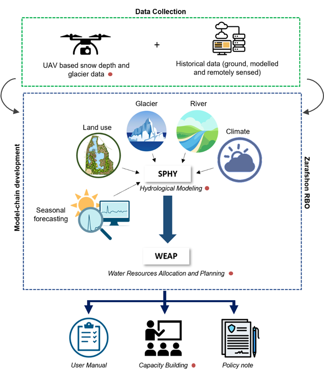
Tajikistan has initiated the Water Sector Reform Program, aiming to enhance water resource planning and allocation across different river basin zones. However, the development of a comprehensive integrated water resources management plan is hindered by a lack of data on snow and glacier melt. The impact of climate change on the cryosphere, including changes in glacier ice storage, snow dynamics, and evaporation rates, further compounds the issue by affecting high mountain water supply and altering runoff composition and overall water availability.
To address this challenge, the “Integrated Rural Development Project” (IRDP), implemented by GIZ as part of the bilateral development project “Towards Rural Inclusive Growth and Economic Resilience (TRIGGER),” focuses on enhancing the value of agricultural production in Tajikistan. As part of the project, the Water Output (Output 1.5) provides technical support to the Ministry of Energy and Water Resources (MEWR) in the Zarafshon River Basin and at the national level. This support includes technical advisory services, capacity building, training measures, and improving access to irrigation water for small-scale farmers. Local relevant stakeholders foreseen as project beneficiaries are MEWR, Zarafshon River Basin (Zarafshon RBO), Center of Glacier Research (CGR), the Institute of Water Problems (IWP) and the Agency for Hydrometeorology, Tajikistan.
The project has three core components: data collection, modeling, and capacity building, as outlined below. Data collection will include both field monitoring campaigns using UAVs and retrieving historical records which could either be past in-situ observations, remotely sensed or modelled data. This comprehensive dataset will be used to set up, calibrate and validate Spatial Processes in Hydrology (SPHY) and WEAP models. The project will use the model-chain to provide the probabilistic flow forecast (likelihood to be in dry, medium, or wet conditions) using the seasonal meteorological forecast data. The SPHY-WEAP model-chain will then be deployed in the Zarafshon RBO-based servers. The results of the model-chain will be used to develop a comprehensive policy guidance note, proposing strategies and a way forward for developing a robust climate-resilient integrated water resources management plan that will ensure both water availability and accessibility across the river basin. Capacity building is a critical component of the project to ensure its sustainability and upscaling. Therefore, six capacity-building trainings (online and in-country) targeting different technical areas of the project will be organized throughout the project.
By undertaking these efforts, we aim to contribute to the successful implementation of Integrated Water Resources Management in Zarafshon and Tajikistan.
The inital Climate Risk Assessment (CRA) by FutureWater in 2021 for the Asian Development Bank (ADB) identified the need for a detailed CRA for the DKSHEP to understand the risk posed by the changing climate on hydropower and the environment. Therefore, the objective of this Climate Risk and Adaptation Assessment (CRA) is to assess the vulnerability of the project components to future climate change and recommend adaptation options for climate-proofing the design. This CRA covers both type 2 adaptation, related to system change and resilience building, as well as type 1 adaptation related to climate-proofing. FutureWater will support ADB to ensure that the project will adequately address climate change mitigation and adaptation in accordance with ADB’s requirements.
FutureWater will make use of state-of-the-art downscaled Coupled Model Intercomparison Project Phase 6 (CMIP6) ensembles, and other relevant hazards and local information to develop this CRA. Insights from the CRA will be used to devise adaptation strategies. FutureWater will also ensure climate resilience measures are incorporated into the detailed design and environmental management planning before finalizing the climate change risk assessment. Together with the client’s engineering and safeguards team (Nepal Electricity Authority), FutureWater will ensure that the detailed design and environmental management plans incorporate all other recommended climate resilience measures and that their implementation is sufficiently detailed including bioengineering techniques, nature-based solutions, and an early warning system. FutureWater will collate the information and work closely with the national geological and GLOF consultants to review all available options for (i) sediment management plan, (ii) upstream catchment management plan, and (iii) emergency preparedness and response plan. FutureWater will provide several capacity-building sessions to the project team on the findings of the initial CRA, and the potential options for climate resilience measures to incorporate in the project design and operation to address the risks identified. Moreover, this project will develop a GHG account and prepare SARD climate change screening and Paris Agreement alignment assessment.
Over the last decades, efficient water resources management has been an important element of EU’s water policies, a topic that is addressed with renewed attention in the revised 2021 EU Adaptation Strategy, which lists the need for a knowledge-based approach towards water-saving technologies and instruments such as efficient water resources allocation. The IPCC special report on oceans and the cryosphere in a changing climate (2019) highlights the combination of water governance and climate risks as potential reasons for tension over scarce water resources within and across borders, notably competing demands between hydropower and irrigation, in transboundary glacier- and snow-fed river basins in Central Asia.
WE-ACT’s innovative approach consists of two complementary innovation actions: the first is the development of a data chain for a reliable water information system, which in turn enables the second, namely design and roll-out of a decision support system for water allocation. The data chain for the reliable water information system consists of real-time in-situ hydrometeorological and glaciological monitoring technology, modelling of the water system (including water supply and demand modelling and water footprint assessments) and glacier mass balance, data warehouse technology and machine learning. The roll-out of the DSS for climate-risk informed water allocation consists of stakeholder and institutional analyses, water valuation methods, the setup of the water information system to allow for a user-friendly interface, development of water allocation use cases, and feedback on water use through national policy dialogues.
The work of FutureWater within the WE-ACT study will focus on estimating the water demand and water footprints of the different users and activities within the Syr Darya river basin. Therefore, the effects of water allocation on water footprints, unmet water demand and environmental flow violations will be evaluated using a set of hydrological models such as SPHY and Water Allocation models (WEAP). This will be done for both the status quo and future scenarios.
Eswatini’s development is at risk by natural drought hazards. Persistent drought is exacerbating the country’s existing challenges of food security and the ability to attain sustainable development. Therefore, FutureWater, Hydrologic, and Emanti Management joined forces to bring together technologies and complementary expertise to implement the GLOW service which includes: short-term and seasonal forecasts of water availability and demand, an alerting service when forecasted water demand is higher than water availability, and water distribution advisories to reduce impact and maximise water security for all water users.
The GLOW service will be piloted in the Maputo River and Mbuluzi River Basins where three-quarters of the population of Eswatini lives, which includes the Hawane dam that supplies water to Mbabane (Capital City of Eswatini) and which is the major water supply source for Maputo, a Delta city (1 million inhabitants) which suffers from water shortages. The main beneficiaries of this project are the Joint River Basin Authority (JBRAS-PB) and the 5 River Basin authorities, AraSul (Mozambique) and the Department of Water and Sanitation (South Africa).
The innovation of GLOW is bringing together proven and award-winning technologies of advanced earth observation, open data, high-performance computing, data-driven modelling, data science, machine learning, operations research, and stakeholder interaction. These technologies require minimum ground truth information, which makes them very scalable and applicable in poorly monitored environments throughout the world. The coherent combination of the technologies into one decision support service ensures the optimum division of water, basically distributing every drop of water to meet the demands of all interests present in large river catchments.
The Asian Development Bank (ADB) identified the need for a detailed Climate Risk and Adaptation (CRA) assessment for the DKSHEP to understand the risk posed by the changing climate on hydropower and the environment. Therefore, the objective of this Climate Risk and Adaptation Assessment (CRA) is to assess the vulnerability of the project components to future climate change and recommend adaptation options for climate-proofing of the design. Therefore, this CRA covers both type 2 adaptation, related to system change and resilience building, as well as type 1 adaptation related to climate-proofing This CRA assesses historic trends in relevant climate-related variables and analyses climate projections for the DKSHEP. Based on these projections, an assessment of the current and future climate risks and vulnerabilities relating to the proposed project activities will be outlined. Finally, recommendations will be presented for climate adaptation measures.
The Swiss Agency for Development and Cooperation’s (SDCs) Global Programme Climate Change and Environment (GP CCE) India is supporting the operationalization of climate change adaptation actions in the mountain states of Uttarakhand, Sikkim and Himachal Pradesh through the phase two of the “Strengthening State Strategies for Climate Action” (3SCA) project that was launched in 2020. The second phase of 3SCA (2020-23), known as the Strengthening Climate Change Adaptation in Himalayas (SCA-Himalayas), while building on the experience and achievements of Phase 1, aims to showcase mountain ecosystem appropriate scalable approaches for climate resilience in water and disaster risk management sectors; using these efforts to enhance the capacities of the institutions across the Indian Himalayan Region (IHR) to plan, implement and mainstream adaptation actions into their programmes and policy frameworks; and disseminating the experiences and lessons at the regional and global level.
Within this programme, SDC has granted a project to FutureWater, together with Utrecht University, The Energy and Resources Institute (TERI), the University of Geneva and a few individual experts. The activities in this project focus on the development and application of climate responsive models and approaches for integrated water resources management (IWRM) for a selected glacier-fed sub-basin system in Uttarakhand and that at the same will find place in relevant policy frameworks paving way for their replication across IHR and other mountainous regions. This will allow the policy makers from the mountain states in India to manage the available water resources in an efficient and effective manner, benefiting the populations depending on these resources.
The combination of future climate change and socio-economic development poses great challenges for water security in areas depending on mountain water (Immerzeel et al., 2019). Climate change affects Asia’s high mountain water supply by its impact on the cryosphere. Changes in glacier ice storage, snow dynamics, evaporation rates lead to changes in runoff composition, overall water availability, seasonal shifts in hydrographs, and increases in extremely high and low flows (Huss and Hock, 2018; Lutz et al., 2014a). On the other and, downstream water demand in South Asia increases rapidly under population growth and increasing welfare boosting the demand for and electricity generation through hydropower. To address and adapt to these challenges integrated water resource management (IWRM) approaches and decision support systems (DSS) tailored to glacier- and snow-fed subbasins are required.
To fulfil the mandate outlined by SDC a framework is presented for IWRM and DSS for Himalayan subbasins consisting of three integrated platforms. (i) A modelling and decision support platform built around a multi-scale modelling framework for glacier and snow fed subbasins, based on state-of-the art and “easy to use” modelling technology. (ii) A stakeholder engagement platform to consult key stakeholders, identify key IWRM issues and co-design a new IWRM plan for Bhagirathi subbasin. (iii) A capacity building platform with on-site training and e-learning modules for the key project components: glacio-hydrological modelling, IWRM and DSS, to ensure the sustainability of the approach and pave the way for upscaling to other subbasins in the Indian Himalayan Region.
The three platforms are designed designed to be flexible, integrated and interactive. Moreover they align with the three outcomes of the project, thus contributing to: develop and validate an integrated climate resilient water resource management approach (Outcome 1); increase technical and institutional capacity in the fields of hydrological modelling, IWRM and DSS (Outcome 2); support the embedding of the IWRM approach tailored to glacier-fed Indian Himalayan subbasins in policies, and provide generic outputs and guidelines to facilitate upscaling to other subbasins in the Indian Himalayan Region (Outcome 3).
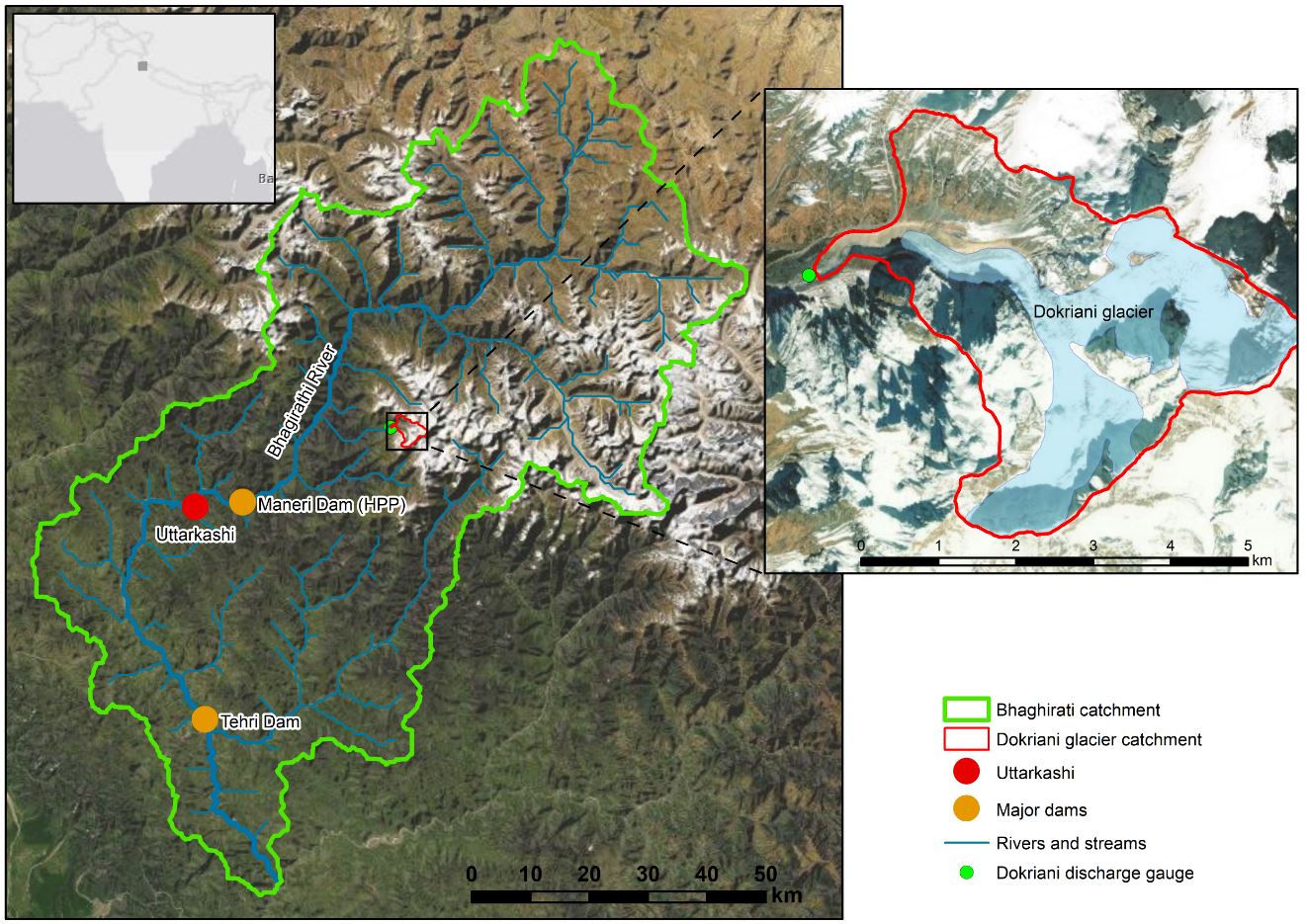
The modelling and decision support platform is designed for operation under the data scarce conditions faced in Himalayan catchments, and yields reliable outputs and projections. The modelling toolset covers the Bhagirathi watershed (Figure below) and consists of 3 hydrological models: (i) a high resolution glacio-hydrological model for the Dokriani glacier catchment (SPHY-Dokriani). Key parameters derived with this model are upscaled to (ii) a distributed glacio-hydrological model that covers the Bhagirathi subbasin (SPHYBhagirathi). Outputs of this model feed into (iii) a water allocation model that overlays the SPHY-Bhagirathi model in the downstream parts of the basin, where water demands are located (WEAP–PODIUMSIM Bhagirathi). This modelling toolset is forced with downscaled climate change projections and socio-economic projections to simulate future changes in water supply and demand in the subbasin. On the basis of stakeholder inputs, adaptation options are identified and implemented in the water allocation model for scenario analysis. Thus, socio-economic projections and adaptation options are co-designed with the stakeholders to ensure maximum applicability, and are tailored to the requirements for formulation of the new IWRM plan. The outputs of the modelling toolset feed into the Decision Support System, where they are presented in such a way that they can truly support decision making in this subbasin. Results of the modelling, decision support and stakeholder engagement platforms jointly support the co-design of an IWRM plan for the subbasin. Capacity in glacio-hydrological modelling, IWRM and the use of DSS is built through a combination of on-site training and e-learning; replicable training modules are developed for glacio-hydrological modelling, IWRM and DSS in general and for this particular approach to support implementation and sustainability.
Overview of the Bhagirathi sub-basin. The inset on the right shows the Dokriani glacier watershed
This glacio-hydrological assessment delivered river flow estimates for three intake locations of hydropower plants in Nakra, Georgia. The assessment included the calibration of a hydrological model, daily river discharge simulation for an extended period of record (1980-2015), and the derived flow duration curves and statistics to evaluate the flow operation of hydropower turbines. The daily flow calculations for the three sites (HPP1, HPP2 and HPP3) can be used in the hydropower calculations, and to assess the overall profitability of the planned investment, considering energy prices, demand, etc.
In the Nakra basin, glacier and snow model parameters were tuned to obtain accurate river flow predictions. Also, the latest technology of remote sensing data on precipitation and temperature (product ERA5) was used to reduce potential errors in flow estimates. Even though these flow estimates are useful for short-medium term evaluations on profitability of the planned investment, climate change pose a challenge for long-term evaluations. Glacier-fed and snow-fed systems, such as the Nakra basin, are driven by a complex combination of temperature and precipitation. Due to future increasing temperature, and changing rainfall patterns, glacier and snow cover dynamics change under climate warming. This can lead to shifts in the flows, like a reduction in lowest flows, and higher discharge peaks when the hydrological system shifts towards a more rainfall-runoff influenced system (Lutz et al. 2016). This can jeopardize the sustainability of the project on the long-term. To provide a better understanding of future river flows, it is recommended to develop a climate change impact assessment.
This hydrological assessment delivered river flow estimates for an intake location of a potential hydropower plant in the Lukhra river, Georgia. The assessment included a tuning of a hydrological model based on knowledge of neighboring basins, daily river discharge simulation for an extended period of record (1989-2019), and the derived flow duration curves and statistics to evaluate the flow operation of hydropower turbines. The daily flow calculations for the site can be used in the hydropower calculations, and to assess the overall profitability of the planned investment, considering energy prices, demand, etc.
In the Lukhra basin, snow model parameters were tuned to obtain accurate river flow predictions. Also, the latest technology of remote sensing data on precipitation and temperature (product ERA5-Land) was used to reduce potential errors in flow estimates. Even though these flow estimates are useful for short-medium term evaluations on profitability of the planned investment, climate change pose a challenge for long-term evaluations. Snow-fed systems, such as the Lukhra basin, are driven by a complex combination of temperature and precipitation. Due to future increasing temperature, and changing rainfall patterns, snow cover dynamics change under climate warming. This can lead to shifts in the flows, like a reduction in lowest flows, and higher discharge peaks when the hydrological system shifts towards a more rainfall-runoff influenced system (Lutz et al. 2016). This can jeopardize the sustainability of the project on the long-term. To provide a better understanding of future river flows, it is recommended to develop a climate change impact assessment.