Looking at global climate change patterns and its increased pressure on natural resources, West African countries like Ghana will be hit very hard. In particular, agriculture, which is the largest water user in Ghana, will be affected by high temperatures and changes in the variability of rainfall. This variability in climate makes crop production and yield more uncertain, as well as farm income. The periods of droughts in Ghana are getting longer and there is increased pressure on water availability from the river basins due to climate change, putting many people and farmers in risk of having too little water. Therefore in this project, we will develop and pilot in the field an innovative tool that will significantly enhance water security in Ghana by reducing the quantity of water needed for irrigation per hectare (up to about 40% less of current water use).

To support the Ghanaian farmers in making the transition to a water secure future, they expressed a need for locally adapted, climate smart irrigation technologies and innovative advice to improve their irrigation practices. To develop such a smart irrigation service, FutureWater is working together with knowledge institute TU Delft, horticulture company Holland Greentech, and social enterprise TAHMO to develop this innovative tool and implement it in the field. This smart irrigation service should be able to translate various weather parameters and data (historical but also real-time data) into crop specific irrigation advice in volumes, but also in minutes for small-scale farmers. The unique and innovative part of this smart irrigation service, called SOSIA+ (Small-scale Open source, Satellite based Irrigation Advice), will be the algorithm to provide advice on how many minutes a farmer should irrigate a specific crop – based on the combination of the TAHMO local weather data and real-time data (normally not taken into account), that will be tailor-made for small scale farmers (normally these services are only for large scale farmers while the predominant type of farmers in Ghana are small scale) and is linked to the innovative drip irrigation systems that Holland Greentech Ghana already sells to farmers (so closely linked to an existing customer base of farmers and a product).

SOSIA+ will initially focus on the city of Kumasi and the Ashanti region, targeting more than 500 farmers and a growing population of more than 4 million people that needs to be fed and are affected by the changing weather patterns and increased water demand. In the long-term, the goal is to transform the horticulture sector in Ghana towards a smart and sustainable practice. By developing the Irrigation Advisory Tool, we can prevent over-irrigation to reduce water use and hence work towards the desired situation of sustainable food production and water security. This project will focus on gathering better weather information, piloting an innovative irrigation tool that is linked to a drip irrigation system to reduce water losses and implement this in the field with lead farmers. This will change the current traditional practices of the farmers leading to less water and energy losses, hence increasing availability of water and the sustainability of food production in light of climate change.

Earlier this year FutureWater and Holland Greentech developed a very first draft of the irrigation advisory application ‘SOSIA’ for Rwanda, with promising results. As one of the main problems in many African countries is that there is no ground network of weather stations, making it very difficult to efficiently manage water resources or generate weather forecasts that are localised and essential for food production, the initial SOSIA project used satellite remote sensing data to overcome this problem. But given the rapidly changing weather patterns due to climate change, the collection of ground data is also essential. This is why TAHMO has been set-up to develop a dense network of weather stations all over Africa and using their data will be very valuable to use for the irrigation tool.

The video below gives a brief summary of the tool created in the previous SOSIA project.

The inital Climate Risk Assessment (CRA) by FutureWater in 2021 for the Asian Development Bank (ADB) identified the need for a detailed CRA for the DKSHEP to understand the risk posed by the changing climate on hydropower and the environment. Therefore, the objective of this Climate Risk and Adaptation Assessment (CRA) is to assess the vulnerability of the project components to future climate change and recommend adaptation options for climate-proofing the design. This CRA covers both type 2 adaptation, related to system change and resilience building, as well as type 1 adaptation related to climate-proofing. FutureWater will support ADB to ensure that the project will adequately address climate change mitigation and adaptation in accordance with ADB’s requirements.

FutureWater will make use of state-of-the-art downscaled Coupled Model Intercomparison Project Phase 6 (CMIP6) ensembles, and other relevant hazards and local information to develop this CRA. Insights from the CRA will be used to devise adaptation strategies. FutureWater will also ensure climate resilience measures are incorporated into the detailed design and environmental management planning before finalizing the climate change risk assessment. Together with the client’s engineering and safeguards team (Nepal Electricity Authority), FutureWater will ensure that the detailed design and environmental management plans incorporate all other recommended climate resilience measures and that their implementation is sufficiently detailed including bioengineering techniques, nature-based solutions, and an early warning system. FutureWater will collate the information and work closely with the national geological and GLOF consultants to review all available options for (i) sediment management plan, (ii) upstream catchment management plan, and (iii) emergency preparedness and response plan. FutureWater will provide several capacity-building sessions to the project team on the findings of the initial CRA, and the potential options for climate resilience measures to incorporate in the project design and operation to address the risks identified. Moreover, this project will develop a GHG account and prepare SARD climate change screening and Paris Agreement alignment assessment.
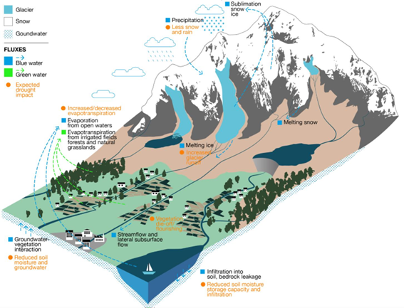
Over the last decades, efficient water resources management has been an important element of EU’s water policies, a topic that is addressed with renewed attention in the revised 2021 EU Adaptation Strategy, which lists the need for a knowledge-based approach towards water-saving technologies and instruments such as efficient water resources allocation. The IPCC special report on oceans and the cryosphere in a changing climate (2019) highlights the combination of water governance and climate risks as potential reasons for tension over scarce water resources within and across borders, notably competing demands between hydropower and irrigation, in transboundary glacier- and snow-fed river basins in Central Asia.

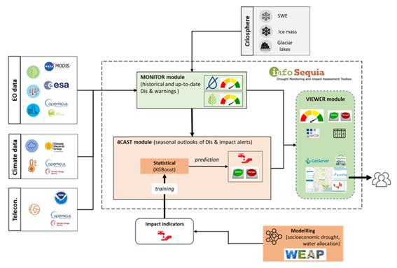
WE-ACT’s innovative approach consists of two complementary innovation actions: the first is the development of a data chain for a reliable water information system, which in turn enables the second, namely design and roll-out of a decision support system for water allocation. The data chain for the reliable water information system consists of real-time in-situ hydrometeorological and glaciological monitoring technology, modelling of the water system (including water supply and demand modelling and water footprint assessments) and glacier mass balance, data warehouse technology and machine learning. The roll-out of the DSS for climate-risk informed water allocation consists of stakeholder and institutional analyses, water valuation methods, the setup of the water information system to allow for a user-friendly interface, development of water allocation use cases, and feedback on water use through national policy dialogues.

The work of FutureWater within the WE-ACT study will focus on estimating the water demand and water footprints of the different users and activities within the Syr Darya river basin. Therefore, the effects of water allocation on water footprints, unmet water demand and environmental flow violations will be evaluated using a set of hydrological models such as SPHY and Water Allocation models (WEAP). This will be done for both the status quo and future scenarios.

Eswatini’s development is at risk by natural drought hazards. Persistent drought is exacerbating the country’s existing challenges of food security and the ability to attain sustainable development. Therefore, FutureWater, Hydrologic, and Emanti Management joined forces to bring together technologies and complementary expertise to implement the GLOW service which includes: short-term and seasonal forecasts of water availability and demand, an alerting service when forecasted water demand is higher than water availability, and water distribution advisories to reduce impact and maximise water security for all water users.

The GLOW service will be piloted in the Maputo River and Mbuluzi River Basins where three-quarters of the population of Eswatini lives, which includes the Hawane dam that supplies water to Mbabane (Capital City of Eswatini) and which is the major water supply source for Maputo, a Delta city (1 million inhabitants) which suffers from water shortages. The main beneficiaries of this project are the Joint River Basin Authority (JBRAS-PB) and the 5 River Basin authorities, AraSul (Mozambique) and the Department of Water and Sanitation (South Africa).

The innovation of GLOW is bringing together proven and award-winning technologies of advanced earth observation, open data, high-performance computing, data-driven modelling, data science, machine learning, operations research, and stakeholder interaction. These technologies require minimum ground truth information, which makes them very scalable and applicable in poorly monitored environments throughout the world. The coherent combination of the technologies into one decision support service ensures the optimum division of water, basically distributing every drop of water to meet the demands of all interests present in large river catchments.

Currently, farmers rely on weather forecasts and advisories that are either general for a given, often wide, region of interest, or highly customized to the farmers’ needs (e.g. by combining large scale atmospheric variables into synthetic parameters of interest). In both cases, such forecasts and advisories often don’t rely at all on observations collected at or around the target cultivated areas, or they are limited to traditional observations provided only by weather stations, without exploiting the full extent of measurements and observations available through European space-based assets (e.g. Galileo GNSS, Copernicus Sentinels) and ground-based radar data.

MAGDA objectives go beyond the state-of-the-art by aiming at developing a modular system that can be deployed by owners of large farms directly at their premises, continuously feeding observations to dedicated and tailored weather forecast and hydrological models, with results displayed by a dashboard and/or within a Farm Management System.

FutureWater is leading the irrigation advisory service of MAGDA, making use of hydrological modelling using SPHY (Spatial Processes in Hydrology). The output expected consists of an operational irrigation service to provide advice on when and how much to irrigate at certain moments during the cropping season, using as input data improved weather forecasts.

During this task, the SPHY water balance model will be setup for three selected demonstrator farms in Romania, France and Italy. Finally, the irrigation advisory will be validated using performance indicators (e.g., water productivity, crop yield analysis, water use efficiency) using ground truth data (e.g., weather stations, moisture probes, crop biomass measurements)

Water resources around the globe are under increasing stress. Among other factors, climate change, rising food and energy demand, and improving living standards have led to a six-fold increase in global water withdrawals over the last century, with significant consequences for water quality and availability, ecosystem health, biodiversity, as well as social stability.

By advancing and linking water system models with models from sectors such as agriculture and energy, biodiversity, or sediment transport, the SOS-Water Project aims to lay the foundations for a holistic assessment framework of water resources across spatial scales. Based on five case studies of river basins in Europe and Vietnam – the Jucar River Basin in Spain, the Upper Danube region, the Danube and Rhine River deltas, and the Mekong River Basin – an interdisciplinary team of researchers from ten institutions across eight countries will develop a multidimensional SOS for water. The framework will enable the assessment of feedback loops and trade-offs between different dimensions of the water system and help address pressing global, regional, and local challenges.

In addition to going beyond state-of-the-art water systems modeling, the project will develop a comprehensive set of indicators to assess and monitor the environmental, social, and economic performance of water systems. The participating researchers will collaborate with regional and local authorities, water user representatives, non-governmental organizations, and citizens to co-create future scenarios and water management pathways. By streamlining water planning at different levels, it can be ensured that water allocation among societies, economies, and ecosystems will be economically efficient, socially fair, and resilient to shocks.

In partnership with project lead IIASA and partners such as Utrecht University and EAWAG, FutureWater is responsible for several tasks under the work package that looks to improve upon existing Earth Observation technologies for monitoring the performance of water systems. New applications will be developed and tested in the context of the SOS-Water case study basins of the Mekong and Jucar rivers.

With over 1,850 km of 500kV lines, 6,200 km of 220kV lines and 15,300 km of 110kV lines, the power transmission system in Uzbekistan is facing challenges with respect to deteriorating infrastructure and unreliable power supply. To address these issues, the Asian Development Bank (ADB) is assisting the Government of Uzbekistan through the “Uzbekistan Power Transmission Improvement Project” which aims to: i) improve the power transmission network capacity and reliability in the northwest region of the country, ii) reduce transmission losses, and iii) improve the operational efficiency of the power sector. This will be done through the i) construction of a new 220kV single-circuit overhead transmission line spanning over 364 km, ii) expansion, rehabilitation, and construction of 3 substations and iii) capacity building and institutional development.

Additionally, given the growing impacts of climate change in the region, FutureWater has been assigned to carry out a climate risk and adaptation assessment for 12 transmission lines and 2 substations in the country. FutureWater will make use of state-of-the-art downscaled Coupled Model Intercomparison Project Phase 6 (CMIP6) ensembles, and other relevant hazards and local information to develop this CRA. The insights from this assessment will enable ADB to justify climate financing for further enhancing the climate resilience of the grid system. Moreover, through the adoption of climate-resilient technologies and adaptation measures based on the climate risk assessment, the country will be able to cut down on their GHG emissions and ensure uninterrupted power supply in light of a changing climate. This will be complimented by deriving adaptation costs to justify the need for climate financing. In addition, FutureWater will also be reviewing the existing meteorological monitoring network and recommending additional potential monitoring sites for improved surveillance in the country.

Uzbekistan is highly sensitive to climate change which will cause changes in the water flows and distribution: water availability, use, reuse and return flows will be altered in many ways due to upstream changes in the high mountain regions, but also changes in water demand and use across the river basin. The resulting changes in intra-annual and seasonal variability will affect water security of Uzbekistan. Besides, climate change will increase extreme events which pose a risk to existing water resources infrastructure. An integrated climate adaptation approach is required to make the water resources system and the water users, including the environment, climate resilient.

This project will support the Ministry of Water Resources (MWR) of Uzbekistan in identifying key priorities for climate adaptation in the Amu Darya river basin and support the identification of investment areas within Amu Darya river basin. The work will be based on a basin-wide climate change risk assessment as well as on the government priorities with an explicit focus on reducing systemic vulnerability to climate change.

The project will undertake:

  • Climate change risk analysis and mapping on key water-related sectors, impacts on rural livelihoods, and critical water infrastructures.
  • Climate change adaptation strategic planning and identify barriers in scaling up adaptation measures at multiple scales with stakeholder consultation and capacity building approach.
  • Identification of priority measures and portfolios for integration into subproject development as well as for future adaptation investment in the Amu Darya river basin. The identification will cover shortlisting of potential investments, screening of economic feasibility, and potential funding opportunities.

FutureWater leads this assignment and develops the climate risk hotspot analysis, and coordinates the contribution of international and national experts, as well as the stakeholder consultation process.

To facilitate the needs of ZIPAK, this training aims to build data-driven capacities relevant to sustainable nature conservation practices and ecosystem-based natural resources management in Iran:

  • Leveraging the Climate Change Knowledge Portal (CCKP) for performing climate risk and vulnerability assessments
  • Leveraging the online dashboard Earth Map for environmental hazard mapping and socio-economic risk assessments
  • Applying the InVest model (Integrated Valuation of Ecosystem Services and Tradeoffs) for assessing ecosystem service provision

The training focuses on knowledge and skills development and how how to meaningfully integrate these capabilities into ZIPAK’s objectives on sustainable management of the environment and natural resources.

Pakistan is ranked as the 8th most climate vulnerable country in the world as per the Global Climate Risk Index (2019) and in recent years has been facing the worst brunt of climate change. Irregular and intense precipitation, heatwaves, droughts, and floods have severely impacted the agriculture and water sector. Approximately, 90% of the country’s freshwater resources are utilized by the agricultural sector. However, lack of information services makes it a challenge to implement a water accounting system for improved water resources management.

The GCF funded project titled “Transforming the Indus Basin with Climate Resilient Agriculture and Water Management” aims to shift agriculture and water management to a new paradigm in which processes are effectively adapting to climate change and are able to sustain livelihoods. FAO Pakistan, as per the request of the Ministry of Climate Change, has designed the project to develop the country’s capacity to enhance the resilience of the agricultural and water sector. There are three major components:

1. Enhancing information services for climate change adaptation in the water and agriculture sectors
2. Building on-farm resilience to climate change
3. Creating an enabling environment for continued transformation

FutureWater will be actively involved in Component 1 which focuses on facilitating the development of a water accounting system and improving the availability and use of information services. Given the limited data availability in the region, FutureWater will integrate the use of remote sensing technologies within the existing Water Accounting methodology to address this gap. A capacity and needs assessment will be conducted and a series of tailor-made trainings will be designed subsequently to enable key government stakeholders to use open-source geospatial analysis tools as well as models to estimate real water savings, particularly in the context of agriculture. The trainings will help build the country’s capacity to implement water accounting at different spatiotemporal scales and cope with the worsening impacts of climate change.